

introduction - Pennsylvania Natural Heritage Program
introduction - Pennsylvania Natural Heritage Program
introduction - Pennsylvania Natural Heritage Program

You also want an ePaper? Increase the reach of your titles
YUMPU automatically turns print PDFs into web optimized ePapers that Google loves.
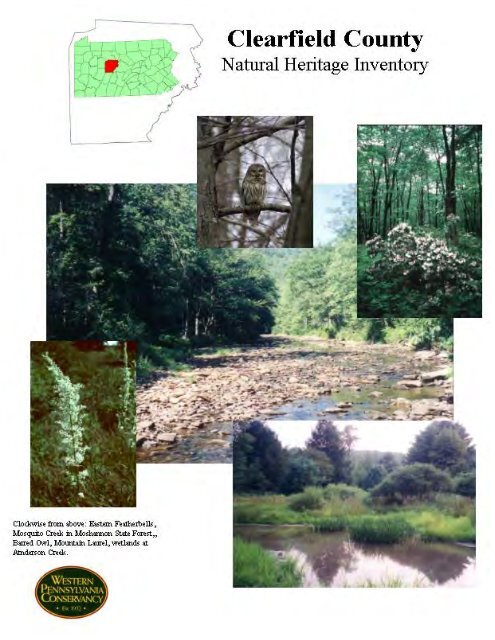
CLEARFIELD COUNTYNATURAL HERITAGE INVENTORYPrepared for:The Clearfield County Planning Office209 Locust St.Clearfield, PA 16830Prepared by:Western <strong>Pennsylvania</strong> Conservancy209 Fourth AvenuePittsburgh, PA 1522217 September 2004This project was funded through grants supplied by the Department of Conservation and <strong>Natural</strong> Resources – Officeof Wild Resource Conservation, the Department of Community and Economic Development, and Clearfield County.Copies of this report are available in electronic format through Western <strong>Pennsylvania</strong> Conservancy’s web site –www.paconserve.org – and through the Clearfield County Planning Office.
PREFACEThe Clearfield County <strong>Natural</strong> <strong>Heritage</strong> Inventory identifies and maps Clearfield County’s mostsignificant natural places. High quality landscapes, exemplary natural communities, rare and uniquespecies and general habitat diversity were all considered as part of the study; these characteristics, andmethods for evaluating areas within the county, are detailed in the report.Although the inventory was conducted using a tested and proven methodology, it is best viewed as apreliminary report rather than the final word on the subject of Clearfield County’s natural heritage.Further investigations could, and likely will, uncover previously unidentified areas of significance.Likewise, in-depth investigations of sites listed in this report could reveal features of further or greatersignificance than have been documented. We encourage additional inventory work across the county tofurther the efforts begun with this study.These studies were conceived as ways to provide information about critical living resources for planningpurposes at numerous levels within both the public and private sectors. Organizations may use theinventory to guide land acquisition and conservation decisions. Local municipalities and the countiesmay use it to help with comprehensive planning, zoning, and the review of development proposals.Developers, utility companies, and government agencies alike may benefit from access to thisenvironmental information prior to the creation of detailed management or development plans. As of thiswriting, approximately two thirds of the counties in the commonwealth have completed inventories; eachinventory bringing the state closer to fulfilling the goal of having studies completed for all counties by theend of 2006.The ability of a community to establish a vision of the future and to bring it to fruition hinges upon itscapacity to assemble information that will enable it to act effectively and wisely. There are manyimportant resources present in Clearfield County that are not addressed in this inventory. Historic,cultural, educational, water supply, agricultural and scenic resources are among the many that the countymust address through other projects and programs. This <strong>Natural</strong> <strong>Heritage</strong> Inventory focuses on the bestexamples of living ecological resources in Clearfield County. Although agricultural lands and open spacemay be included as part of inventory areas, the emphasis of the designation and delineation of the areasare the ecological values present.The inventory does not confer protection to any of the areas listed in the report. It is, however, a tool forinformed and responsible decision-making. Areas described in this report include both public and privatelands. Permission obtained to visit sites for the purposes of this study does not confer any agreement ofvisitation for other purposes. Please respect the rules and regulations governing public lands and the rightsand desires of private landowners when considering visits to any areas detailed in this report.The Western <strong>Pennsylvania</strong> Conservancy (WPC) served as the principal investigator for the study andprepared the report and maps that are the products of the study. Established in 1932, Western<strong>Pennsylvania</strong> Conservancy is a private non-profit conservation organization headquartered in Pittsburgh.WPC’s mission is to save the places we care about by connecting people to the natural world. As part ofits mission, WPC works to sustain the natural heritage of the Commonwealth: its native plant, animal, andhabitat resources. To reach its goals, WPC initiates conservation projects independently and establishespartnerships with agencies and organizations having similar interests.Along with The Nature Conservancy and The Department of Conservation and <strong>Natural</strong> Resources, WPCis a partner in the <strong>Pennsylvania</strong> <strong>Natural</strong> <strong>Heritage</strong> <strong>Program</strong> (PNHP) which is responsible for collecting,tracking and interpreting information regarding the Commonwealth’s biological diversity. Countyinventory projects are an important part of the work of PNHP.i
Over the history of these studies, the format and presentation of information in the reports has changed aswe strive to provide a more complete and usable document for the numerous users mentioned. Wewelcome comments and suggestions related to these changes. Any questions concerning sites, updates tothe inventory, or the reports themselves may be addressed to the Western <strong>Pennsylvania</strong> Conservancy, 209Fourth Avenue, Pittsburgh, PA 15222; phone: (412) 288-2777.The Clearfield County Planning Commission administered this study. Requests for copies of theinventory can be addressed to the Clearfield County Planning Commission, 209 East LocustStreet, Clearfield, PA 16830, phone: (814) 765-2641.ii
ACKNOWLEDGEMENTSWe would like to acknowledge the many citizens and landowners of the county and surrounding areaswho volunteered information, time, and effort to the inventory and granted permission to access land.We especially thank:Dr. Carol Loeffler, pilot for the aerial reconnaissance of the countyJodi McCluskey, Clearfield County Planning DirectorClearfield County Planning CommissionRobert G. Merrill, <strong>Pennsylvania</strong> Bureau of ForestryDr. Hank Webster, <strong>Pennsylvania</strong> State University-DuboisDr. Joseph Hummer, <strong>Pennsylvania</strong> State University-DuboisClearfield County NHI Advisory CommitteeMany others contributed to the inventory effort. Without their help, the inventory would not have seencompletion.This report has incorporated ideas and approaches developed for conservation science initiatives recentlyundertaken in other states, most notably the Massachussetts BioMap project and the Maryland GreenInfrastructure project; we gratefully acknowledge the vision of these projects as providing the basis forimproved ways to represent conservation information in the <strong>Natural</strong> <strong>Heritage</strong> Inventory reports.Jessica McPhersonEcologistWestern <strong>Pennsylvania</strong> Conservancyiii
TABLE OF CONTENTSPreface…………………………………………………………………………………………….. iAcknowledgements……………………………………………………………………………….. iExecutive Summary………………………………………………………………………………. viIntroduction……………………………………………………………………………………….. iBackgroundEcological Science Background…………………………………………………………………………. 2NHI Mapping……………………………………………………………………………………………. 5<strong>Natural</strong> History Overview of Clearfield County…………………………………………….………….. 6Physiology & Geology……………………………………………………………………………… 6Soils…………………………………………………………………………….…………………… 6Vegetation……………………………………………………………………………….………….. 11Methods…………………………………………………………………………………………… 15Site Selection……………………………………………………………………………………………. 15Ground Survey…………………………………………………………………………………………… 15Data Analysis……………………………………………………………………………………. 16ResultsContiguous Forest Blocks……………………………………………………………………………….. 20Landscape Conservation Areas…………………………………………………………………………. 26Important Bird Areas…………………………………………………………….……………………… 36Biological Diversity Areas—listed by townshipBeccaria Township, Coalport Borough, Glen Hope Borough, IrvonaBorough……………………………………………………………..……………………... 39Bell Township, Mahaffey Borough, Newburg Borough………………………………………. 41Bigler Township……………………………………………………………………………….. 47Bloom Township………………………………………………………………………………. 49Boggs Township, Wallaceton Borough……………………………………………………….. 53Bradford Township……………………………………………………………………………. 55Brady Township, Troutville Borough……………………………….………………………… 57Burnside Township, Burnside Borough, New Washington Borough…………………………. 59Chest Township, Westover Borough………………………………………………………….. 63Cooper Township……………………………………………………………………………… 67Covington Township…………………………………………………….……………………. 69Decatur Township, Osceola Borough, Chester Hill Borough………………………………… 75Ferguson Township…………………………………………………………………………… 77Girard Township………………………………………………………….…………………… 79Goshen Township………………………………………………………………….………….. 85Graham Township…………………………………………………………………………….. 89Greenwood Township…………………………………………………….…………………… 95Gulich Township, Ramey Borough…………………………………………………………… 95Huston Township……………………………………………………………………………… 99Jordan………………………………………………………………………………………….. 107Karthaus……………………………………………………………………………………….. 109Knox…………………………………………………………………………………………… 111Lawrence Township, Clearfield Borough…………………………….………………………. 113Morris Township………………………………………………………….…………………... 119Penn Township, Grampian Borough, Lumber City Borough…………………………………. 121iv
Pike Township, Curwensville Borough……………………………………………………….. 123Pine Township………………………………………………………………………………… 125Sandy Township, Dubois City, Falls Creek Borough………………………………………… 133Union Township………………………………………………………………………………. 137Woodward Township, Brisbin Borough, Houtzdale Borough………………………………… 139Recommendations…………………………………………………………………….…………. 141Glossary………………………………………………………………………………………….. 145Literature Cited……………………………………………………………………….…………. 147AppendicesAppendix I: Significance Ranks……………………………………………………………………. 152Appendix II: <strong>Pennsylvania</strong> <strong>Natural</strong> <strong>Heritage</strong> <strong>Program</strong>…………………………………………….. 152Appendix III: CNHI Site Survey Form……………………………………………………………. 154Appendix IV: <strong>Natural</strong> Community Classification…………………………………………………. 156Appendix V: Status of SpeciesA. Federal Status……………………………………………………….……………………. 162B. <strong>Pennsylvania</strong> Status………………………………………………………………………. 163C. Global & State Element Ranks…………………………………………………………… 166Appendix VI: Plants and Animals of Special Concern in Clearfield County………….………….. 168Appendix VII: Sustainable Forestry Information Sources…………………………………………. 170LIST OF TABLESTable 1. <strong>Natural</strong> <strong>Heritage</strong> Areas categorized by significance………………………………………………. viiiTable 2. Examples of <strong>Natural</strong> & Anthropogenic Disturbance……………….……………………………… 3Table 3 Soil Associations of Clearfield County…………………………………………….………… 10Table 4 Synthesis of factors used for setting size thresholds formatrix-forming communities in the Northern Appalachians……….………………………… 17Table 5 Summary Statistics of Contiguous Forest Blocks………………………………….………… 24Table 6. Ownership of lands within forested Landscape Conservation Areas……………………………… 30LIST OF FIGURESFigure 1. Physiographic Provinces & Ecoregions of Clearfield County………………………………… 7Figure 2. Soil Associations of Clearfield County…………………………………………….…………. 9Figure 3 Contiguous Forest Blocks in <strong>Pennsylvania</strong>………………………………………………………… 20Figure 4 Contiguous Forest Blocks in Clearfield County…………………….………………. ……………. 21Figure 5. Biological Diversity Areas, Landscape Conservation Areas, andImportant Bird Areas in Clearfield County……..…………………………………………….. 26Figure 6. Watersheds of Clearfield County……………………………………………………………... 30v
EXECUTIVE SUMMARYIntroductionA healthy natural landscape is vital to the qualityof life in human communities and to the survivalof the native biodiversity that is our naturalheritage, connecting us to the past and the futureof our communities and our cultural identity.For all of us, the natural landscape and theecosystem processes it supports provide manyservices, such as clean water and clean air, andrenew the resources from which we draw food,raw materials, and economic vitality. Industriesthat include forest products, fishing, outdoorrecreation, and nature tourism depend upon anatural landscape that is well-stewarded andpositioned for long-term sustainability.The first steps in working towards stewardshipof ecological health in our landscape are tocharacterize the ecosystems it hosts, understandhow they function, and assess how they may besensitive to human impacts. This reportcontributes to this endeavor by mapping thelocation and describing the character of many ofthe county’s most significant ecological areas.Additionally, it provides information regardingtheir sensitivity to various land use activities.The report focuses on identifying anddocumenting areas that support exemplarynatural communities, broad expanses of intactnatural ecosystems, and species of specialconcern. Its aim is to provide information tohelp county, state, and municipal governments,private individuals, and business interests plandevelopment with the preservation of anecologically healthy landscape for futuregenerations in mind.Maps are a key feature of the inventory,outlining the areas identified as supportingimportant ecological elements. The maps do notpinpoint the exact location of species of concernor natural communities but rather representcritical habitat and the surrounding area orlandscape necessary to support critical habitatsand the elements (plants, animals, naturalcommunities) of concern. A summary table anda written description of the sites accompanyeach map. Potential threats andrecommendations for protection of the sites areincluded for each of the individual sitedescriptions.<strong>Natural</strong> <strong>Heritage</strong> Inventory MappingTo provide the information necessary to plan forconservation of biodiversity—at the species,community, and ecosystem levels—andcontinued function of ecosystem services, weprovide a several-tiered system of maps.Biological Diversity Areas (BDAs)Ecological significance: BDAs are a groupof sites intended to provide representativeexamples of all naturalcommunity/ecosystem types native to thestudy region. Biological Diversity Areas areranked and described to highlight thoseareas in the best condition and those areaswhich make important contributions tobiodiversity by harboring species orcommunities which have declined or arenaturally uncommon in the state, region, orworld.Conservation Planning Application: BDAsare mapped according to their sensitivity tohuman activities. “Core” areas delineateessential habitat that can absorb very littleactivity without substantial impact to thenatural features of concern. “SupportingLandscape” areas delineate lands that are notessential habitat, but support natural featuresof concern by maintaining vital ecologicalprocesses or secondary habitat. SupportingLandscape Areas may be able toaccommodate some types of activity withoutdetriment to natural resources of concern.Contiguous Forest Blocks MapEcological Significance: To aidinterpretation of the relative ecological valueof forested lands in the county, we provide amap of all blocks of forest that contain morethan 250 acres of core area. Table 5 (pg. 24)lists several statistics to further describe theecological character of the blocks.vi
Conservation Planning Application: Theinformation on forest block ecologicalcharacteristics listed in the table can beapplied to a variety of different purposes.They can be used to compare the relativeecological significance of areas for forestconservation planning. The wetland andforest metrics may be relevant to speciesfocusedplans or studies, and the stream andwetland metrics can help inform planningefforts for water quality and aquatic habitatconservation.Landscape Conservation Areas (LCAs)Ecological Significance: LCAs aredesignated around landscape features thatfunction as a linking element within anaggregation of BDAs, and around largeblocks of contiguous forest. Large areas ofcontiguous forest have unique and importantecological value because they are capable ofsupporting species that require interior forestconditions and have large territory sizes, andhave the potential to support a forestecosystem with long-term viability.Conservation Planning Application: Theselarge regions in relatively natural conditioncan be viewed as regional assets; theyimprove quality of life by providing alandscape imbued with a sense of beautyand wilderness, they provide a sustainableeconomic base, and their high ecologicalintegrity offers unique capacity to supportbiodiversity and human health. Planningand stewardship efforts can preserve thesefunctions of the landscape by limiting theoverall amount of land converted to otheruses, and by considering the large-scalepattern of the landscape while endeavoringto minimize fragmentation of natural cover.These goals can be facilitated by limitingnew infrastructure development, includingroads and sewer lines, within LCAs, and byutilizing existing cleared areas for newprojects.Important Bird AreasEcological Significance: IBAs aredesignated by the PA Audubon Society tohighlight those portions of the landscapeespecially important in supporting birddiversity.Conservation Planning Application:Planning for these areas should considerhow best to maintain their value as birdhabitat. The value of large-scale IBAs arisesfrom the interior forest habitat containedwithin them, and thus the recommendationsfor LCA stewardship to minimize forestfragmentation are applicable. Smaller-scaleIBAs are typically based around naturalcommunities that have particular habitatvalue, and thus a high degree of protectionshould be accorded to the sites.MethodsPresently, thirty-eight County Inventories havebeen completed throughout <strong>Pennsylvania</strong>. TheClearfield County <strong>Natural</strong> <strong>Heritage</strong> Inventoryfollowed the same methodologies as previousinventories, which proceeded in the followingstages:• site selection• ground survey• data analysisSite SelectionA review of the <strong>Pennsylvania</strong> <strong>Natural</strong> DiversityInventory (PNDI) database (see Appendix II)determined where sites for special concernspecies and important natural communities wereknown to exist in Clearfield County.Knowledgeable individuals were consultedconcerning the occurrence of rare plants andunique natural communities in the county.Geological maps, USGS topographical maps,National Wetlands Inventory maps, USDA soilsurveys, recent aerial photos, and publishedmaterials were also used to identify areas ofpotential ecological significance (Reschke1990). Once preliminary site selection wascompleted, reconnaissance flights over chosenareas of the county were conducted. Wetlandswere of primary interest during fly-overs inClearfield County.vii
Ground SurveyAreas identified as potential sites werescheduled for ground surveys. After obtainingpermission from landowners, sites wereexamined to evaluate the condition and qualityof the habitat and to classify the communitiespresent. Field survey forms (Appendix III, pg.154) were completed for each site. The flora,fauna, level of disturbance, approximate age ofcommunity and local threats were among themost important data recorded for each site. Incases where permission to visit a site was notgranted, when enough information was availablefrom other sources, or when time did not permit,sites were not ground surveyed.Data AnalysisData obtained during the 2001 and 2002 fieldseasons was combined with prior existing dataand summarized. All sites with species orcommunities of statewide concern, as well asexceptional examples of more common naturalcommunities were selected as BiologicalDiversity Areas (BDAs). Spatial data on theelements of concern were then compiled in ageographic information system (GIS) formatusing ESRI ArcView 3.2a software. Theboundaries defining each BDA were based onphysical and ecological factors, andspecifications for species protection provided byjurisdictional government agencies. The BDAswere then assigned a significance rank based onsize, condition, rarity of the unique feature, andthe quality of the surrounding landscape (seeAppendix I, pg. 152 for further description ofranks). Landscape Conservation Areas weredesignated around landscape features thatprovide a uniting element within a collection ofBDAs, or large blocks of contiguous forestidentified using GIS-based spatial analysis.ResultsThe Clearfield County <strong>Natural</strong> <strong>Heritage</strong>Inventory recognizes areas of ecologicalsignificance— 29 Biological Diversity Areasand 11 Landscape Conservation Areas.The results of the <strong>Natural</strong> <strong>Heritage</strong> Inventory forClearfield County are summarized below intabular form. Table 1 lists the <strong>Natural</strong> <strong>Heritage</strong>Areas categorized according to their significanceto the protection of the biological diversity andecological integrity of the region. Significanceranks are Exceptional, High, Notable, andCounty (for a full explanation of these ranks,see Appendix I, pg. 152).Table 1. <strong>Natural</strong> <strong>Heritage</strong> Areas categorized by significanceSite Municipality Description Page No.Exceptional SignificanceCamp Wopsononock Forest BDAChest Creek Wetlands BDAGulich Twp.Reade Twp.Bell Twp.Newburg Boro.Ferguson Twp.A large natural area with several forest communitytypes, natural wetland areas, and calcareoussandstone outcrop habitats.A floodplain forest community and a seepagewetland community with a plant species of specialconcern.Crystal Springs Bog BDA Pine Twp. A natural wetland and surrounding upland area thathost three species of special concernDimeling Road BDA Lawrence Twp. A population of the Allegheny plum, a plant speciesof global and state concern.9642126114viii
Table 1. <strong>Natural</strong> <strong>Heritage</strong> Areas categorized by significanceSite Municipality Description Page No.Moshannon State Forest LCA Gibson Twp. The second-largest contiguous forest block34Huston Twp.Lawrence Twp.Goshen Twp.Girard Twp.Covington Twp.Karthaus Twp.Pine Twp.identified in PA; supports a range of forestcommunity types and many natural wetlandsas well.High SignificanceBilger Rocks BDA Bloom Twp. A sandstone rock outcropping that hosts a plant 50species of special concernBurnside Oxbow BDA Burnside Twp. Several wetland communities and a population of 60featherbells (Stenanthium gramineum), a plantspecies of special concern in <strong>Pennsylvania</strong>Chest Creek South Floodplain BDA Chest Twp. A floodplain area hosting a heron rookery 64Fulton Railroad Tunnel BDA Lawrence Twp. An area used as winter hibernation grounds by ananimal species of special concern.Panther Rocks BDA Pine Twp. A sandstone rock outcropping that hosts a plantspecies of special concernShagger's Inn Impoundment BDA Lawrence Twp. A shallow water impoundment used by osprey, abird species of special concern, for nesting.Twelvemile Run Tributaries BDACentral Allegheny Front LCASandy Lick Creek Wetlands BDASW Elk State Forest LCANotable SignificanceAnderson Creek & Whitney RunWetlands BDACole Run BDACovington Twp.Gibson Twp.Woodward Twp.Gulich Twp.Sandy Twp.Union TwpHuston Twp.Snyder Twp.Huston TwpPine Twp.Union Twp.Covington Twp.Karthaus Twp.Three natural wetlands and a plant species of specialconcernA large contiguous forest block, mainly in CentreCounty.A section of Sandy Lick Creek with several naturalwetland complexes, hosting three species of specialconcern.A large contiguous forest block that falls across theClearfield-Elk county line.Portions of Anderson Creek and Whitney Runincluding many natural wetland areasThe watershed of Cole Run, a stream classified asExceptional Value by the PA-DEPGifford Run Vernal Pools BDA Girard Twp. Several vernal pool communities 80Gifford Run Wetlands BDALeft Branch Moose CreekHeadwaters BDAGirard Twp.Goshen Twp.A very large natural wetland complex in theheadwaters of Gifford RunPine Twp. A natural wetland with a unique plant community 127Quehanna Right-of-Way BDA Covington Twp. Site hosting a plant of special concern 71Rogue's Harbor Run BDA Chest Twp. The watershed of Rogue's Harbor Run, a stream 64classified as Exceptional Value by the PA-DEPWolf Run Wetland BDA Sandy Twp. A natural wetland in the headwaters of Wolf Run 135ix1141281187131134311007081
Table 1. <strong>Natural</strong> <strong>Heritage</strong> Areas categorized by significanceSite Municipality Description Page No.Anderson Creek-MontgomeryCreek LCABennett Branch Headwaters LCAHaslett Run LCAPenn Twp.Lawrence Twp.Pine Twp.Union Twp.Bloom Twp.Pike Twp.Huston Twp.Sandy Twp.Pine Twp.Union Twp.Penn Twp.Greenwood Twp.Brady Twp.A large contiguous forest block containing the upperwatershed of Anderson and Montgomery Creeks.A large contiguous forest block in the headwaters ofBennetts BranchA large contiguous forest block spanning HaslettRun, Bell Run, Curry Run, and Poplar Run; forest invariable condition.Bell Twp.S. Central Allegheny Front LCA Gulich Twp. A large contiguous forest block; although fallingmainly in Centre & Blair Counties, its extension intoSE Clearfield County supports the CampWopsononock BDA.SGL # 77 LCAHuston Twp.Sandy Twp.A large block of contiguous forest spanning the Elkand Clearfield County line.County SignificanceBell's Landing Floodplain BDA Greenwood Twp. One of the few areas of natural floodplain along theWest Branch Susquehanna RiverLaborde Branch Wetlands BDALaurel Run & Saunders Run BDALaurel Run Tributary WetlandMosquito Creek-County LineWetlands BDASandy Twp.Brady Twp.Lawrence Twp.Huston Twp.Jay Twp. (Elk)Huston Twp.Pine Twp.Benezette Twp.(Elk), Girard Twp.<strong>Natural</strong> wetland habitat along the Laborde BranchfloodplainSeepage wetland communities in a forestedlandscape along Laurel & Saunders Run333230313292134115A natural wetland in the headwaters of Laurel Run 101A large complex of natural wetlands along MosquitoCreekParker Dam Beaver Ponds BDA Huston Twp This site recognizes two wetland complexes, bothbeaver-influenced, in the headwaters of Mud Run.Robert's Run Wetlands BDAGoshen Twp.Girard Twp.Several natural wetland communities in theheadwaters of Roberts RunSB Elliot Cabins Wetland BDA Pine Twp. A natural wetland in the headwaters of Lick Run 129South Bennett Branch Wetlands Huston Twp. A seepage wetland and a riparian wetland habitat 105BDAStony Run Headwaters WetlandBDAMontgomery Run LCAMoravian Run-Alder Run LCAPine Twp.Pine Twp.Union Twp.Cooper Twp.Graham Twp.Bradford Twp.Two natural wetland complexes in the headwaters ofStony RunA large, highly contiguous block of forest containingthe watershed of Montgomery Run.A contiguous block of forest around Moravian Runand Alder Run; uniquely intact in this region of thecounty.82102861303433x
Discussion and RecommendationsStatus of natural features todayThe landscape and waterways of ClearfieldCounty have undergone considerable changeover the course of human settlement, mostnotably from timber extraction, mining, andagriculture. During the timber boom in the earlytwentieth century, almost the entire landscape ofthe county underwent general clear-cutting, andsubsequently there were widespread fires.Mining began with deep mine excavation, andtransitioned to mostly strip mining operations asmining technology developed. Strip mining hasbeen extensive, resulting in an environmentaltransformation of a large proportion of thecounty land. Another legacy of mining iswidespread water pollution that seriouslyimpairs aquatic ecosystems in many of thecounty’s waterways. Throughout the county, thecondition of ecological resources today closelyreflects the history of human land use.Although mining and timber extraction remainprevalent in the county, natural communitieshave redeveloped across large swaths of thelandscape previously used for timber extraction,coal mining, and clay mining. Especially in thenorthern part of the county, there are large areasof contiguous forest that provide abundanthabitat for forest dwelling species. ClearfieldCounty spans several major regional topographictransitions—with the Allegheny Front boundingthe western edge of the county, the extremenorthern end of the Allegheny Mountainsterminating in the southeastern part of thecounty, and an extension of the High AlleghenyPlateau across the northern part of the countytransitioning into rolling low plateau landscapeto the west and into the West BranchSusquehanna River valley to the south. Theforest ecosystems historically present reflectedthis position at the juncture of three ecoregions:the high-elevation northern areas were similar inecological composition to the High AlleghenyPlateau, the southeast had mesophyticinfluencedforests, and the northwest was anextension of the Western Allegheny Plateaucommunities.Today the condition of forest communitiesvaries across the county. While many areasxihave re-grown and redeveloped a broadecological spectrum of natural forestcommunities, some areas are fragmented byroads, surface mined areas, artificial clearings,or utility rights-of-way. The character andquality of forested areas also reflects variabletimber management practices, with some areasless sustainably managed to date than others.Over-browsing by deer poses a threat tobiological diversity and forest regeneration inmany regions of the county. Of the threeecoregions in the county, the High AlleghenyPlateau has the greatest area of relatively intactforest, while the mesophytic-influenced and theWestern Allegheny Plateau portions of thecounty are more fragmented, with fewer wellrecoveredexamples of typical forestcommunities.However, despite the variable condition of theforests, their contiguity is a great asset to thecounty’s ecological integrity and is regionallyimportant in sustaining mid-atlantic populationsfor many animal species. Contiguous forestedareas offer enhanced habitat value overfragmented forested areas. While a number ofgeneralist species can succeed and reproduce insmall patches of forest, many species can onlyutilize large, unbroken tracts of forest. Becausemany of the forested areas in Clearfield Countytoday are large, contiguous patches, they supportspecies which are declining in other areas of thestate and the continent due to lack of habitat.The forests of Clearfield County have thepotential for even greater significance tobiodiversity in the future. Some species canonly find appropriate habitat in old-growthforests, because the structures they need forshelter or the food sources they require are notpresent in younger forests. While there are fewareas in Clearfield County today that are oldgrowth, the large expanses of younger forestsprovide the potential for the future development— in ecologically strategic areas — of prime oldgrowth habitat that can host species that aretoday in decline throughout the continent due tolack of habitat.Within the matrix of forest in the county, uniquecommunities including vernal pools, forestedseepage wetlands, headwaters shrub swamps,sandstone rockhouses, and calcareous rock
outcrops occur in conjunction with specifictopographic or geologic conditions. Althoughthese communities are limited in their extent,occupying a comparatively small portion of thenatural landscape in the county, they are ofparticular value to the county’s biodiversitybecause they support groups of specialistspecies—such as amphibians that breed only invernal ponds, or plant species that live only inacidic, northern-influenced wetlands—thatwould otherwise not be present in the county.Planning for biodiversity and ecologicalhealth tomorrowProvision for the future health of ecologicalresources in Clearfield County will require acombination of efforts to steward specific sitesthat host unique species and communities,broader-scale planning to maintain the uniquecontiguity of its forested regions, and restorationefforts to alleviate water pollution and restoreecological function to damaged landscapes andwaterways.Forests—contiguity and connectivityIn the forested landscapes, objectives for largescaleplanning should include maintaining andincreasing contiguity and connectivity of naturalland. The extensive forested area in the northernportion of the county—part of the second-largestforest block in <strong>Pennsylvania</strong>— is regionallysignificant in supporting populations of interiorforest-dependent species such as someneotropical migrant birds, and species that havelarge home range requirements such as theNorthern goshawk or the fisher. Municipal andregional land use plans can support maintenanceof forest contiguity by encouraging residential orcommercial projects to re-develop in existingtown centers or re-use previously alteredlandscapes, and by orienting new infrastructurealong existing corridors rather than throughunfragmented natural landscapes. Anotherplanning consideration is the maintenance ofnatural landscape corridors that span betweenforest patches and connect forests, wetlands, andwaterways. Many species—examples aboundamong birds, amphibians, and dragonflies— usean aquatic or wetland habitat in one phase oftheir life, then migrate to an upland, forestedhabitat for their adult life. Either habitat alonexiicannot be utilized unless a corridor existsbetween them.Aquatic Ecosystems—treasures and challengesClearfield County’s waterways, ranging fromremote mountain streams to the West BranchSusquehanna River, include some of thecounty’s most scenic features and some of itsgreatest ecological challenges. Due to theimpacts of acid deposition and extensive miningin a landscape of naturally acidic geology, mostof the county’s streams have low pH and aquaticecosystems that range from slightly impaired tonearly devoid of life. Remediation of minedrainage pollution is the greatest challenge torestoration of water quality and living aquaticecosystems in many of the county’s waterways.In some areas reduction in the release of otherpollutants into runoff, including sediments,nutrients, and chemical contaminants, will alsobe necessary to improve water quality.Stewardship or restoration of native forestcommunities in riparian buffers along waterwayswill greatly improve water quality and enhancethe habitat value for various aquatic and semiaquaticspecies. Attending to the basicecological functions of streams and wetlandswill pay dividends by ensuring the continuedavailability of quality water for humancommunities, enabling the restoration of healthyfisheries, and enhancing the quality of life forwhich the region is known.Evaluating proposed activity within <strong>Natural</strong><strong>Heritage</strong> AreasA very important part of encouragingconservation of the <strong>Natural</strong> <strong>Heritage</strong> Areasidentified within the Clearfield County <strong>Natural</strong><strong>Heritage</strong> Inventory is the careful review ofproposed land use changes or developmentactivities that overlap with <strong>Natural</strong> <strong>Heritage</strong>Areas. The following overview should provideguidance in the review of these projects oractivities.Always contact the Clearfield County PlanningOffice. The County Planning Office should beaware of all activities that may occur within<strong>Natural</strong> <strong>Heritage</strong> Areas in the county so that theymay interface with the County ConservationDistrict and other necessary organizations or
agencies to better understand the implications ofproposed activities. They also can supplyguidance to the landowners, developers, orproject managers as to possible conflicts andcourses of action.Once informed of the proposed activity, theCounty Planning Office should then contact the<strong>Pennsylvania</strong> <strong>Natural</strong> <strong>Heritage</strong> <strong>Program</strong>(Western <strong>Pennsylvania</strong> Conservancy office) fordirection in arranging further review of theactivity. Depending upon the resourcescontained within the <strong>Natural</strong> <strong>Heritage</strong> Area, theagencies/entities responsible for the resourcewill then be contacted. The points of contactand arrangements for that contact will bedetermined on a case-by-case basis by theCounty and PNHP. In general, theresponsibility for reviewing natural resources ispartitioned among agencies in the followingmanner:• U.S. Fish and Wildlife Service for allfederally listed plants or animals.• <strong>Pennsylvania</strong> Game Commission for allstate and federally listed terrestrialvertebrate animals.• <strong>Pennsylvania</strong> Fish and BoatCommission for all state and federallylisted aquatic vertebrate and invertebrateanimals.• <strong>Pennsylvania</strong> Bureau of Forestry for allstate and federally listed plants.• <strong>Pennsylvania</strong> <strong>Natural</strong> <strong>Heritage</strong><strong>Program</strong> (PNHP) for all naturalcommunities, terrestrial invertebratesand non-listed species.PNHP and agency biologists can provide moredetailed information with regard to thelocation of the natural resources of concern in aproject area, the needs of the particular resourcesin question, and about potential impacts of theproject to those resources.If a ground survey is necessary to determinewhether significant natural resources are presentin the area of the project, PNHP or an agencybiologist will recommend a survey beconducted. PNHP, through Western<strong>Pennsylvania</strong> Conservancy, or otherknowledgeable contractors can be retained forthis purpose. Early consideration of naturalresource impacts is recommended to allowsufficient time for thorough evaluation. Giventhat some species are only observable oridentifiable during certain phases of their lifecycle (i.e., the flowering season of a plant or theflight period of a butterfly), a survey may needto be scheduled for a particular time of year.If the decision is made to move forward with aproject in a sensitive area, WPC can work withmunicipal officials and project personnel duringthe design process to develop strategies forminimizing the project’s ecological impact whilemeeting the project’s objectives. The resourceagencies in the state may do likewise.Note that projects involving numerous activitiesthat will require state permits will require aPNDI review. Consultation with WPC oranother agency does not take the place of thePNDI review. However, early consultation andplanning as detailed above can provide for amore efficient and better integrated permitreview, and a better understanding among theparties involved as to the scope of any neededproject modifications.xiii
INTRODUCTIONA healthy natural landscape is vital to the quality of life in human communities and to the survival of thenative biodiversity that is our natural heritage, connecting us to the past and the future of our communitiesand our cultural identity. For all of us, the natural landscape and the ecosystem processes it supportsprovide many services, such as clean water and clean air, and renew the resources from which we drawfood, raw materials, and economic vitality. Industries including forest products, fishing, outdoorrecreation, and nature tourism depend upon a natural landscape that is well-stewarded and positioned forlong-term sustainability.The first steps in working towards stewardship of ecological health in our landscape are to characterizethe ecosystems it hosts, understand how they function, and assess how they may be sensitive to humanimpacts. This report contributes to this endeavor by mapping the location and describing the character ofmany of the county’s most significant ecological areas. Additionally, it provides information regardingtheir sensitivity to various land use activities.The report focuses on identifying and documenting areas that support exemplary natural communities,broad expanses of intact natural ecosystems, and species of special concern. Its aim is to provideinformation to help county, state, and municipal governments, private individuals, and business interestsplan development with the preservation of an ecologically healthy landscape for future generations inmind.Maps are a key feature of the Inventory, outlining the areas identified as supporting important ecologicalelements. The maps do not pinpoint the exact location of species of concern or natural communities butrather represent critical habitat and the surrounding area or landscape necessary to support critical habitatsand the elements (plants, animals, natural communities) of concern. A summary table and a writtendescription of the sites accompany each map. Potential threats and recommendations for protection of thesites are included for each of the individual site descriptions.The existence of habitat for specific plants and animals and the rarity within the state of an area’s naturalcommunities are important selection criteria for <strong>Natural</strong> <strong>Heritage</strong> Areas, but equally important is the sizeand contiguousness of an area containing good quality natural features. Large areas provide the backbonethat links habitats and allows plants and animals to shift and move across sizable portions of thelandscape.Particular species names, common and scientific, are provided in coordination with the appropriatejurisdictional agency. The U. S. Fish and Wildlife Service oversees the protection of federally threatenedand endangered species. On the state level, plants and terrestrial invertebrates are under the jurisdictionof the <strong>Pennsylvania</strong> Department of Conservation and <strong>Natural</strong> Resources (DCNR). Mammals and birdsare under the protection of the <strong>Pennsylvania</strong> Game Commission (PGC). Reptiles, amphibians and aquaticanimals are under the jurisdiction of the <strong>Pennsylvania</strong> Fish and Boat Commission (PFBC). Some plantand animal species are under threat due to unauthorized collection or poaching and these species aretherefore not identified within the text of this report in order to provide some measure of protection forthe species.An Advisory Committee made up of agencies’ representatives, county and municipal officials,representatives of various groups and businesses in the county and interested residents helped to identifyareas for consideration and guide the course and presentation of the findings of the study. Additionally,many landowners and residents provided valuable information and access to areas of interest during thestudy. Copies of the Clearfield County <strong>Natural</strong> <strong>Heritage</strong> Inventory are provided to each municipality inthe county and are also available for review through the County Planning Office, the Clearfield CountyLibrary System and electronically through the Western <strong>Pennsylvania</strong> Conservancy’s web site.1
BACKGROUNDEcological Science Background`An Ecosystem PerspectiveIn order to ensure that the value natural landscapes offer to human quality of life continues to beavailable for future generations, management decisions must consider the health of entireecosystems. All parts of an ecosystem are interconnected—the survival of any particular speciesor the continuation of a given natural process depends upon the system as a whole, and in turnitself contributes a role towards maintaining the system.Ecosystem: “the complex of interconnected living organisms inhabiting particular area orunit of space, together with their environment and all their interrelationships andrelationships with the environment.” –Ostroumov 2002The Ecological Function of BiodiversityBecause an ecosystem’s parts are interconnected, ecosystem health is fundamentally dependenton the condition of its components, which are its biological diversity, as well as the continuousvariation in the physical condition of the landscape (geology, soil type, slope, moisture level,etc.). Biological diversity relates to ecosystem health on many levels. Individual plant, animal,and microbe species each play a role in sustaining ecosystem processes such as nutrient cycling,decomposition, and plant productivity: declines in native species diversity alter these processes(Naeem et al. 1999). Genetic diversity is vital to the long-term viability of species because itprovides evolutionary potential, without which species may not be able to adapt successfully toenvironmental changes. The range of variation in the physical landscape and the action ofecological processes over time creates a variety of habitat types that provide for a broad range ofnative species and natural communities.The distribution of species, along with habitat types and natural communities that support themacross the landscape, is important to consider in conservation planning. For example, some typesof plant communities are ubiquitous, such as red-oak mixed hardwood forests, and have awidespread distribution. Others are more restricted in the habitats they can occupy, such as a frogspecies that requires a particular type of wetland, such as a vernal pond. These species have amore limited distribution. For effective conservation, the full range of natural variation in habitatand community types must be protected.Biological Diversity or Biodiversity- The variety of life in all its forms and all its levels oforganization (i.e., ecosystem, species, genetics), including the ecological structures,functions, and processes at all of these levels–Hunter 1990, Society of American Foresters 19912
<strong>Natural</strong> Resilience, Human Activities, & Conservation StewardshipNature has a great deal of resilience, but not all natural phenomena are alike and some are moresensitive than others. The various components of an ecosystem have different levels ofsensitivity to disturbance and to human activities in the landscape, as well as differing capacitiesto recover following disturbance. Some species, natural processes, and communities tolerate oreven depend upon natural disturbances; these are often also able to tolerate human-induceddisturbances that have similar impacts. At the other end of the spectrum, species may beextremely sensitive to disturbance if they require very specialized habitats that form over a longperiod of time (such as a bog or a limestone outcrop), and they may have a poor ability to recoverfollowing disturbance if they reproduce slowly or disperse across the landscape slowly. Manyecosystem processes—such as nutrient formation and transport, or soil formation-- are sustainedby natural phenomena such as precipitation or decomposition, and the continued action of theseforces will re-instate these processes following disturbance. However, natural processes operateat different rates; some natural processes operate very slowly, and some natural communitiesdevelop very slowly, and damage to these ecosystem components can take centuries to repair.Examples of such slow processes are the formation of soil on dry sandstone slopes, or thedevelopment of a peat bog community.Although some species, including several rare species, are aided by on-site disturbance (e.g.clearing or mowing), in general, human-caused disturbance negatively impacts natural systems.With wide-ranging anthropogenic disturbance, some plant and animal species may be completelyextirpated from an area because they cannot compete or survive under newly created conditions.Human disturbances are a permanent part of the landscape, but decisions about the type, timing,and extent of future disturbances are important to the natural ecological diversity that remains.Stewardship of the natural landscape to preserve its potential for future generations requiresunderstanding of the diverse components of our ecosystems and consideration in our activitiesthat we not exceed their capacity to recover.Table 2. Examples of natural and anthropogenic disturbances (adapted from Scott et.al. 1999)*<strong>Natural</strong> EventsAnthropogenic Eventsfireresidential developmentdisease epidemicroad, trail, railroad linefloodtelephone line, utility linedroughtdam, canalhurricane/tornado/landslidecommercial developmentlandslidemodern agricultureice stormmininglogginggrazing*Entries in italics denote reversible disturbances, while those in Roman usually represent longtermThe Effects of Human-Influenced Landscapes on Biodiversity.andEcosystem FunctionOver the last three centuries, human settlement has created a landscape in which natural cover isinterspersed with areas modified for cultural purposes. Several landscape characteristics havebeen found to explain variation in patterns of biodiversity within the landscape. These include the3
amount of habitat fragmentation, edge characteristics, connectivity between habitat patches anddiversity of habitats found with the landscape.Habitat FragmentationFragmentation of formerly continuous forested landscapes into smaller, more isolated tracts hasan effect on plant and animal composition and structure. The size of a landscape and the way it isperceived varies among the individual species (Pearson et al. 1995). For small or relativelyimmobile species, such as plants or insects, a few hectares of habitat may be sufficient. Whereasother species such as the black bear, Northern Goshawk, bobcat, fisher, and Barred Owl— havelarge individual home ranges and require large expanses of forest to support a viable population.Dramatic declines have been documented across the region in some of these species and in othersthat depend on core forest and large tracts of forest (Yahner 1988, Hansen & Urban 1992,Robinson et al. 1995). Because few large, unfragmented areas of forest remain, those that doremain are especially important as refuges for these species. <strong>Pennsylvania</strong> has a high proportionof the forest land remaining in the mid-Atlantic states, and thus our forests are critically importantto the regional survival of populations of birds and other forest wildlife (Goodrich et al. 2003,Rosenberg and Wells 1995).Edge EffectAs a forested landscape is fragmented, the amount of forest edge relative to core areas increases.Traditionally, good wildlife management often was synonymous with created edge habitats sincemany “game” species are more abundant near edges. Today, it is recognized that many “nongame”species evolved within extensive areas of unfragmented forest. Consequently, edges maybe detrimental due to the increased presence of predators and non-native species. Forest edgesdiffer in vegetative structure, generally making them less suitable for native species andincreasing the likelihood of success by invasives. The influence of an edge may extend up to300’; therefore, those areas greater than 300’ from an edge are considered “core” forest areas thatoffer better-quality habitat conditions for “forest interior” species such as the Allegheny woodrat,woodland salamanders, Scarlet Tanager, Ovenbird, and Black-throated Blue Warbler. Thepattern of human development has created a landscape in which the majority of forest in<strong>Pennsylvania</strong> is influenced by edge effects, and does not offer “core” conditions, because itborders roads, utility rights-of-way, and other non-forest uses (Goodrich et al. 2003).ConnectivityThe features that fragment natural cover into small tracts are often impassable to wildlife andinterrupt the mechanisms by which plant propagules disperse. When a patch of natural landscapebecomes isolated from other natural habitat, the short- and long- term survival of species withinthat patch are threatened. Many species depend on several habitat types in the course of theirlives, and will immediately decline if isolated from one of the necessary habitats. For example,some species of salamander breed in wetlands but live in upland forest outside of breedingseason. Even where a species can meet its habitat requirements within a patch, isolation threatensthe long-term survival of a population by curtailing opportunities for immigration or emigrationwith neighboring areas. The presence of corridors may facilitate the movement of species acrossboundaries or through inhospitable habitats. These movements across the landscape not only helpto sustain the numbers of a population, but also sustain its genetic viability by exchanging geneticmaterial between populations. Over time, isolated small populations lose genetic diversity, andthus the capacity to respond to change in the environment (Ridley 2003).4
<strong>Natural</strong> <strong>Heritage</strong> Inventory MappingGuiding Principles:Noss (1992) suggests the following principles to guide conservation efforts:1. Represent, in a system of protected areas, all native ecosystem types and seral stages across theirnatural range of variation2. Maintain viable populations of all native species in natural patterns of abundance and distribution3. Maintain ecological and evolutionary processes, such as disturbance regimes, hydrologicalprocesses, nutrient cycles, and biotic interactions, including predation.4. Design and manage the system to be responsive to short-term and long-term environmentalchange and to maintain the evolutionary potential of lineages.Additionally, we emphasize the importance of maintaining connectivity between habitats andcontiguity of some large patches of habitat.Key to Maps:To provide the information necessary to plan for conservation according to these principles, weprovide a several-tiered system of maps.Biological Diversity AreasEcological significance: a group of sites intended to provide representative examples of allnatural community/ecosystem types native to the study region. Biological Diversity Areas areranked and described to highlight those areas in the best condition and those areas which makeimportant contributions to biodiversity by harboring species or communities which have declinedor are naturally uncommon in the state, region, or world.Conservation Planning Application: Biological Diversity Sites are mapped according to theirsensitivity to human activities. “Core” areas designate essential habitat that can absorb very littleactivity without substantial impact to the natural features of concern. “Supporting Landscape”areas designate lands that are not essential habitat, but support natural features of concern bymaintaining vital ecological processes or secondary habitat. Supporting Landscape Areas may beable to accommodate some types of activity without detriment to natural resources of concern.Contiguous Forest Blocks MapEcological Significance: To aid interpretation of the relative ecological value of forested lands inthe county, we provide a map of all blocks of forest that contain more than 250 acres of core area.Table 5 (pg. 24) lists several statistics to further describe the ecological character of the blocks.Conservation Planning Application: The information on forest block ecological characteristicslisted in the table can be applied to a variety of different purposes. They can be used to comparethe relative ecological significance of areas for forest conservation planning, the wetland andforest metrics may be relevant to species-focused plans or studies, and the stream and wetlandmetrics can help inform planning efforts for water quality and aquatic habitat conservation.5
Landscape Conservation AreasEcological Significance: LCAs are designated around landscape features that function as a linkingelement within an aggregation of BDAs, and around large blocks of contiguous forest. Largeareas of contiguous forest have unique and important ecological value because they are capable ofsupporting species that require interior forest conditions, species that have large territory sizes,and have the potential to support a forest ecosystem with long-term viability.Conservation Planning Application: These large regions in relatively natural condition can beviewed as regional assets; they improve quality of life by providing a landscape imbued with asense of beauty and wilderness, they provide a sustainable economic base, and their highecological integrity offers unique capacity to support biodiversity and human health. Planningand stewardship efforts can preserve these functions of the landscape by limiting the overallamount of land converted to other uses, and by considering the large-scale pattern of thelandscape while endeavoring to minimize fragmentation of natural cover when planningactivities. These goals can be facilitated by limiting new infrastructure development, includingroads and sewer lines, within LCAs, and by utilizing existing cleared areas for new projects.Important Bird AreasEcological Significance: IBAs are designated by the PA Audubon Society to highlight thoseportions of the landscape especially important in supporting bird diversity.Conservation Planning Application: Planning for these areas should consider how best tomaintain their value as bird habitat. The value of large-scale IBAs arises from the interior foresthabitat contained within them, and thus the recommendations for LCA stewardship to minimizeforest fragmentation are applicable. Smaller-scale IBAs are typically based around naturalcommunities that have particular habitat value, and thus a high degree of protection should beaccorded to the sites.Geologic FeaturesEcological Significance: These include those areas that illustrate regional geologic processes,landforms or scenery and are those that are recognized as outstanding in <strong>Pennsylvania</strong> by Geyerand Bolles (1979, 1987). These places are not necessarily of importance to biological diversityand are therefore not considered <strong>Natural</strong> <strong>Heritage</strong> Areas. However, they are included as naturalhistory features in the county.Conservation Planning Application: These sites may be of interest for preservation due to theirunique historic value, and often offer good opportunities for on-site natural history education.6
<strong>Natural</strong> History Overview of Clearfield CountyThe natural landscape is best described as an ecosystem, a term that describes a group of interacting livingorganisms and the physical environment they inhabit. Climate, topography, geology and soils areparticularly important factors in the development of ecosystems (forests, fields, wetlands) and physicalfeatures (streams, rivers, mountains). These combined factors provide the framework for locating andidentifying exemplary natural communities and species of special concern in the county. The followingsections provide a brief overview of the physiology, soils, surface water, and vegetation of ClearfieldCounty.<strong>Natural</strong> disturbances such as tornados, blow-downs, ice storms, and fires have historically played a largerole in the formation of ecosystems. Human-induced disturbances have also influenced the character ofecosystems throughout history. Before European settlement, Native Americans cleared land foragriculture and settlement, and may also have set fires. Human activities since European settlement havebeen even more dramatically influential in forming and altering the character of Clearfield County’secosystems, causing extinction of some species and the <strong>introduction</strong> of others.Physiography and GeologyA physiographic province is a geographic region united by similar geology and other physicalcharacteristics. Physiography influences a region’s topography and climate. These two variables, alongwith bedrock type, significantly affect soil development, hydrology, and land use patterns of an area.Additionally, both physiography and geology are important to the patterns of plant communitydistribution, which in turn influences animal distribution. Because of the differences in climate, soils, andmoisture regimes, certain plant communities are expected to occur within some provinces and not others.Clearfield County lies entirely within the Pittsburgh Low Plateau Section of the Appalachian PlateauPhysiographic Province (figure 1, pg 7). The Appalachian Plateau province is underlain by layers ofrock, predominantly sandstones and shales, that originated from sediment deposition and compression.These layers were uplifted 500-400 million years ago when two island chains collided with the easternedge of North America (the Taconic and Acadian orogenies – mountain-building events) to form aplateau elevated above the surrounding regions. Unlike the Ridge and Valley province to the east, therock layers in the plateau region did not fold extensively to form mountain ridges; topographic relief atthe surface in this area is mostly defined by stream valleys eroded and downcut over geologic time.Although the land of Clearfield County shares a similar geologic history, it encompasses significantvariation in climate due to strong elevational differences between different portions of the county. Thecounty falls across the juncture of three ecoregions, the High Allegheny Plateau, the Western AlleghenyPlateau, and the Central Appalachian Mountains (figure 1, pg. 9). The northern section of the county ishigher elevation, an extension of the high plateau area to the north. The northwestern corner of thecounty falls across the easternmost edge of the Western Allegheny Plateau, and is lower in elevation thanthe High Allegheny Plateau and characterized by more rolling hills. The West Branch of theSusquehanna River has cut a deep valley through the center of the county; its tributaries, streams such asBell Run, Haslett Run, and Poplar Run, descend several hundred meters from the high elevation plateauto meet the river channel. South of the river is the very northern extent of the Central AppalachianMountains. This section of the county is generally lower elevation, except where the northern ends of themountains lift the land into broadly rolling ridges.The rock layers that reach the surface in Clearfield County are classified according to their age of origininto seven formation types: the Allegheny, Burgoon, Casselman, Glenshaw, Huntley Mountain, MauchChunk, and Pottsville, Rockwell, and Shenango-Oswayo (undivided). Sandstone is the predominant rocktype in most of the county, with shale, conglomerate, siltstone, and coal layers also interspersed.8
Table 3. Soil Associations of Clearfield CountySoilAssociationRayne-Gilpin-ErnestParent MaterialsResiduum weathered fromshale, siltstone, and finegrainedsandstoneDescriptionWell-drained and moderately welldrained, deep and moderately deep,gently sloping to very steep soils onhilltops, ridges, hillsides, and footslopes.Percentageof County48Land UsePrimarily forest, mostly mixed hardwoods: some areas onhillsides used for pasture and hay, some hilltops and benchesused for cultivated crops, hay, pasture. Use limitations areslope, erosion, and the seasonal high water table.Cookport-Hazleton-ClymerResiduum weathered from finegrainedand coarse-grainedsandstoneModerately well-drained and welldrained, deep, nearly level tomoderately steep soils on broaduplands, on ridges, and on hillsideson the Allegheny Plateau28Most areas of this association are in mixed hardwoods or arereverting to forest. Use limitations are slope, erosion, stoneson the surface, and the seasonal high water table.Hazleton-DekalbResiduum weathered from finegrainedand coarse-grainedsandstone.Well-drained, deep and moderatelydeep, moderately steep to very steepsoils on hillsides7All areas of this association are wooded; slope and stones onthe surface limit the soils of this association for mostnonfarm uses.Udorthents-Gilpin-RayneAtkins-Philo-MonongahelaUdorthents (60%): materialdisturbed during mining.Gilpin & Rayne (15% each):residuum from shale, siltstone,and fine-grained sandstone.Atkins & Philo: Recentalluvium from sandstone,siltstone, and shale.Monongahela: old alluviumweathered from acid shale andsandstoneWell drained to somewhat poorlydrained, shallow to deep, nearly levelto very steep soils on hilltops, ridges,benches, and foot slopesPoorly drained to moderately welldrained, deep, nearly level and gentlysloping soils on floodplains andterraces.134Consists mostly of areas disturbed during surface-mining;most unmined areas reverting to forest, with some areas usedfor pasture and hay. Suited to farming, but Udorthentsgenerally require reclamation. Slope, erosion, and theseasonal high water table are the main limitations.Much of the acreage of this association is wooded or usedfor urban development. Some areas are used for cultivatedcrops, hay, and pasture. Soils are suited to farming andtrees: main limitations are erosion, the seasonal high watertable, and flooding. Limited by flooding and seasonal highwater table for most nonfarm uses.10
SoilsSoil character exerts a strong influence on vegetation, as all plant species have individual requirements for nutrientavailability, moisture levels, and pH level. A soil association is a natural grouping of soils based on similarities inclimatic or physiographic factors and soil parent materials. It may include a number of soil types provided they areall present in significant proportions (Canadian Soil Information System, 2003). The soils of Clearfield Countyhave been described in Soil Survey of Clearfield County, <strong>Pennsylvania</strong> (USDA, 1988). Table 3 (pg. 10)summarizes information from the Soil Survey about soil associations found in Clearfield County.VegetationForest CommunitiesClearfield County is a predominantly forested landscape. As is true of most forests in <strong>Pennsylvania</strong>, the forestsof Clearfield County are almost all second- or third- growth stands; there are few known areas of old-growthforest in the county. The three ecoregions which the county is at the juncture of each have characteristic forestcommunity types, and the forests of Clearfield County appear to reflect its position at the transition zonebetween ecoregions. However, the current composition of the forests has been influenced not only by the rangeof variation in natural characteristics such as soil, geology, and climate, but also by the relatively extremeconditions experienced during recent history, including clearcutting and widespread fires near the turn of thecentury, decades of severe deer overbrowsing, and the acidification of soils from decades of industriallyacidified precipitation.The Central Appalachian Mountains originally contained mixed mesophytic forest in mesic conditions, and oakforests in drier sites. The mixed mesophytic forest is characterized by a diverse canopy with shared dominanceamong several species, and an extremely diverse herbaceous layer (Braun 1950). As Clearfield County is at theextreme northern edge of the Central Appalachian Mountains, mesic forests are limited to lower slopes atrelatively low elevations. Many of the more southerly distributed species that characterize the mixedmesophytic forests are absent, and the overall diversity is not as high as is typical far south. The mesic forestsof Clearfield County are mesophytic-influenced rather than true mixed mesophytic forests. Braun (1950)characterized the region along Allegheny Front and just west of the front as a transition zone, with mesicforests along valleys and coves originally composed of sugar maple (Acer saccharum), beech (Fagusgrandifolia), tuliptree (Liriodendron tulipifera), red oak (Quercus rubra), basswood (Tilia americana), redmaple (Acer rubrum), red elm (Ulmus rubra), ash (Fraxinus sp.), black cherry (Prunus serotina), shagbarkhickory (Carya ovata), black birch (Betula lenta), chestnut (Castanea dentata), chestnut oak (Quercusmontana), walnut (Juglans nigra), occasional white pine, (Pinus strobus) and hemlock (Tsuga canadensis).On upper slopes, drier sites, and higher elevations, the forest communities are dominated by oaks – primarilychestnut oak (Quercus montana), but also red oak (Quercus rubra) and black oak (Quercus velutina).American chestnut (Castanea dentata) was once an important component of this forest, until the species wasdecimated by the chestnut blight in the early 20 th century. Today, red maple and black birch are common,while white oak (Quercus alba), sassafras (Sassafras albidum), and black gum (Nyssa sylvatica) are occasional.There is often a shrub layer of mountain laurel (Kalmia latifolia) and blueberry (Vaccinium angustifolium, V.pallidum), and a heath-dominated understory.The High Allegheny Plateau is characterized by northern hardwood and hemlock/white pine – northernhardwood forests. Few records exist describing the character of forests in this region previous to Europeansettlement, and thus it is difficult to assess how the current composition of the forests compares to its historiccondition. However, studies of land survey records in Allegheny National Forest, and of old growth areas inEast Tionesta Creek suggest that the High Allegheny Plateau forests were once dominated by hemlock andbeech, with white pine stands interspersed. Today those species are much less prevalent, while red maple,black cherry, and sugar maple have greatly increased (Whitney 1990, Braun 1950). The herbaceous layer istypified by a few ubiquitous species such as intermediate wood fern (Dryopteris intermedia), wild sarsaparilla11
(Aralia nudicaulis), Canada mayflower (Maianthemum canadense), and partridgeberry (Mitchella repens).Mesic ravines and valleys typically have a stronger component of yellow birch and hemlock. In the northernplateau portion of Clearfield County, these communities are typical, while oak-heath communities similar tothose described for the Central Appalachian Mountains are found at higher elevations and on dry slopes.The original Western Allegheny Plateau forests appear to have been dominated by white oak (Quercus alba),with shagbark hickory (Carya ovata), red maple (Acer rubrum), shingle oak (Quercus imbricaria), scarlet oak(Quercus coccinea), chestnut oak (Quercus montana), black oak (Quercus velutina), red oak (Quercus rubra),American chestnut (Castanea dentata), and black cherry (Prunus serotina) present in various mixtures.In Clearfield County the less-disturbed forests tend to resemble the type characteristic of the ecoregion they fallwithin, but also display features of adjacent ecoregional types, especially following along the lines oftopographic transitions. For example, the forests of the southern part of the county tend to contain a morediverse mixture of canopy trees, including species such as tulip poplar (Liriodendron tulipifera), green ash(Fraxinus pensylvanica), swamp white oak (Quercus bicolor), and cucumber magnolia (Magnolia acuminata),which have a more southerly distribution—and these species can also be found following the valleys thatextend north of the West Branch into the High Allegheny Plateau. Conversely, forests with more northernspecies such as yellow birch (Betula allegheniensis) and wild sarsaparilla (Aralia nudicaulis) are found athigher elevations in the lower half of the county as well. In the southeast corner of the county, shingle oak(Quercus imbricaria), typical of Western Allegheny Plateau forests, is an important component of relativelyundisturbed forests and reaches the northeast edge of its range.Wetland CommunitiesWetlands provide essential habitat for many plant and animal species, as well as valuable ecosystem servicessuch as water filtration and flood control. The ecological character of a wetland is influenced by local soil type,disturbance history, bedrock composition, and hydrological regime. Types of wetlands range from forestedseeps where groundwater saturates the surface only when heavy precipitation raises the water table, to openmarshes that are continuously flooded, to low areas along streambanks that are flooded during high waterevents, to beaver meadows where the water level fluctuates over relatively long periods of time. Some types ofwetland, such as those that are created by beaver dams, develop very quickly, and major changes can beobserved in their character over mere decades. However, other types of wetland, such as sphagnum bogs, formextremely slowly, their present-day condition resulting from slow ecological processes operating over manythousands of years.In the landscape of Clearfield County, wetlands occur naturally at the headwaters of streams, in the floodplainsof streams and rivers, in areas where groundwater intercepts the surface of the ground (seepages and springs),and in beaver-impounded areas. Each of these settings provides different habitat values for native biodiversity.Wetlands resulting from excavations and impoundments are also present in the landscape; although they mayprovide habitat for typical wetland species, they were not included in this study because artificially createdwetlands typically do not host as rich or distinctive an assemblage of native species as do natural wetlands.Headwaters wetlandsThese wetlands occur in broad depressions high in a watershed where precipitation accumulates beforecoalescing into a stream channel. They may also be fed by groundwater seepage. The underlying surfacegeology is predominantly sandstone, providing little mineral enrichment, and the wetlands appear to rangein pH from somewhat acidic to highly acidic. Vegetation is usually patchy with vegetation structureresponding to slight variations in elevation. Shrubs tend to occupy higher zones, graminoids (grass-likeplants) occupy semi-saturated areas, while sphagnum and other emergent species occupy low, hydric areas.The historic condition of these wetland areas is somewhat uncertain, as there are no known descriptionsfrom before the original forests were logged in the late 1800s. Many of the wetlands contain large whitepine or hemlock stumps, indicating they were once forested; however, very little tree regeneration can beobserved in the wetlands today. Removal of the forest canopy may have elevated the water table, thus12
preventing the establishment of seedlings and permanently converting palustrine forested areas to openshrub or herbaceous wetlands. However, not all of the wetlands contain stumps, and these may havehistorically been open wetlands.Understanding these wetlands is further complicated by questions about the role of peat formation andbeaver activity in their history. The acidic character of the wetlands and the fact that a few of the wetlandstoday contain somewhat substantial peat accumulation suggests the possibility that some may have beenpeatlands. Peatlands develop when dead plant matter, usually sphagnum moss or graminoid vegetation,does not decompose and accumulates over a long period of time to form a spongy mat. Without mineralenrichment from surrounding bedrock, the environment typically becomes extremely acidic and nutrientpoor. Few plant species can tolerate such conditions, and thus the community that develops consists ofhabitat specialists, many of which are rare species in <strong>Pennsylvania</strong> because there are very few suchhabitats. Climatic conditions are not highly favorable for peat formation. Also, beaver were historically apart of this landscape, and it is ambiguous what their role may have been to influence peatlanddevelopment. Before European settlement the beaver population is estimated to have been much higherthan it is today, and thus it is likely that beaver occupied these wetlands at least periodically if notcontinually, and that this disturbance is a natural part of their history and development. Beaver dams causea cycle of ponding and vegetative re-colonization that might interrupt the process of peat formation, andalso can convert forested wetlands to open wetlands. Today, several of the county’s natural wetlands arecurrently occupied by beaver and others appear to contain former beaver ponds now undergoingsuccession.Floodplain wetlandsFloodplain wetland communities occur along rivers and streams in low-lying areas. These locations areperiodically inundated by the floodwaters of spring rains and snow melt or seasonal intense storm events,but may be dry for much of the year. They are predominantly forested, but also may have more openportions dominated by shrubs or herbs, especially where flood activity is most frequent and intense.In central <strong>Pennsylvania</strong>, floodplain forests are characterized by a canopy containing some combination ofsilver maple (Acer saccharinum), eastern sycamore (Platanus occidentalis), tulip poplar (Liriodendrontulipifera), black willow (Salix nigra), green ash (Fraxinus pensylvanica), American elm (Ulmusamericana), or box-elder (Acer negundo). Shrubs and vines common to these forests include spicebush(Lindera benzoin), ninebark (Physocarpus opulifolius), silky dogwood (Cornus amomum), Virginia creeper(Parthenocissus quinquefolia), and poison ivy (Toxicodendron radicans). Floodplain forest communitiesreceive severe disturbances from floodwaters including erosion, scouring by ice and debris, and/ordeposition of considerable quantities of sediment and debris. Only species with adaptations or tolerance forthese kinds of conditions can survive here. However, conditions also tend to be relatively mesic andnutrient-rich, due to continual influx of organic material borne by floodwaters, and thus a unique anddiverse plant community is typically present. In Clearfield County, the best examples of floodplain forestare found along the West Branch Susquehanna River and along broad floodplain areas of the large creeks inthe southern portion of the county, such as Chest Creek and Clearfield Creek.Seepage wetlandsA final major category of wetlands highlighted in this report are seepage wetlands. These wetlands formwhere underground water reaches the surface. Rainwater not only runs off the soil surface to accumulate inobservable above-ground bodies of water, such as streams and lakes but drains through the soil toaccumulate in and flow through bedrock layers, following fissures and areas of low density rock. Wheregroundwater intersects the surface, a broad area of saturated soil called a “seep” will form if the volume islow, and a concentrated stream of water termed a spring will be formed if the volume is higher. Theseepage wetlands highlighted in this report form at the foot of slopes; precipitation received by the uplandareas sinks down through loose, permeable layers of sandstone bedrock, is re-directed laterally upon13
encountering a more dense layer of rock, and eventually emerges at the surface. Groundwater dissolvesminerals from the bedrock layers through which it flows, and thus may substantially influence the chemicalenvironment of a seepage wetland. Seeps in Clearfield County are expected to be fairly acidic, as thebedrock is predominantly sandstone, which contains few soluble minerals. They are typically shaded byforest canopy, and thus provide consistently cool and wet habitat conditions which certain plant and animalspecies thrive upon. Many species of salamanders use seeps, and typical plant species are jewelweed(Impatiens sp.), bee balm (Monarda sp.), slender manna-grass (Glyceria melicaria), golden ragwort(Senecio aureus), wood sorrel (Oxalis acetosella), scabrous sedge (Carex scabrata), northern awned sedge(Carex gynandra), mad-dog skullcap (Scutellaria lateriflora), marsh pennywort (Hydrocotyle americana),a sedge (Carex torta), marsh marigold (Caltha palustris), false nettle (Laportea canadensis), woodhorsetail (Equisetum sylvaticum) and golden saxifrage (Chrysosplenium americanum).Wetlands and MiningWhere mining has occurred in the upland areas above any wetland that receives seepage inputs, drainagethrough the disrupted bedrock layers will typically contaminate these groundwater flows with dissolvedmetals (mainly iron, aluminum, and manganese) and acids. Upon reaching the surface and encounteringoxygen in the air, some of the metal compounds convert to solid form, thus accumulating in seepage areasas the orange (iron), bluish-white (aluminum), or black (manganese)-colored sediment characteristicallyassociated with mining drainage. Aluminum, manganese, and high acidity are all toxic to aquatic life; ironis less toxic. However, the accumulation of sediments of any of the metals degrades aquatic habitats byblocking light needed by aquatic plants and microorganisms, and clogging the tissues of aquatic animals.The impacts of abandoned mine discharges (AMD) on a particular wetland will depend on theconcentration of the contaminants in the discharge and the volume of the discharge, relative to the overallvolume of the wetland.14
METHODSThe methods used in the Clearfield County <strong>Natural</strong> <strong>Heritage</strong> Inventory followed established <strong>Pennsylvania</strong> <strong>Natural</strong><strong>Heritage</strong> <strong>Program</strong> procedures, which are based on those used by Anonymous (1985), G.A. Reese et al. (1988), andA.F. Davis et al. (1990). <strong>Natural</strong> <strong>Heritage</strong> Inventories proceed in three stages: 1) site selection based on existingdata, map and aerial photo interpretation, recommendations from local experts, and aerial reconnaissance; 2)ground surveys; and 3) data analysis and mapping.Site SelectionInventory site selection is guided by information from a variety of sources. A review of the <strong>Pennsylvania</strong><strong>Natural</strong> <strong>Heritage</strong> <strong>Program</strong> database (see Appendix II, pg. 152) determined what locations were previouslyknown for species of special concern and important natural communities in Clearfield County. Local citizensknowledgeable about the flora and fauna of Clearfield County were contacted for site suggestions.Individuals from academic institutions and state and federal agencies that steward natural resources (PennState University-Dubois, PA Game Commission, PA Bureau of Forestry, PA Department of EnvironmentalProtection, PA Fish Commission) were also contacted to obtain information about lands or resources theymanage. National Wetland Inventory maps, compiled by the US Fish and Wildlife Service, were used tolocate wetlands of potential ecological significance within the county. General information from othersources such as soil maps, geology maps, earlier field studies, and published materials on the natural historyof the area helped to provide a better understanding of the area’s natural environment.Aerial photographs were reviewed to identify sites for ground survey. Initial study of aerial photos revealedlarge-scale natural features (e.g., contiguous forest, wetlands, vernal pools, shale barrens), disturbances (e.g.,utility line rights-of-way, strip mines, timbered areas) and a variety of easily interpretable features. Somesites could be eliminated from consideration if they proved to be highly disturbed or fragmented or purelyattributable to human-made features (e.g., impoundments, clearings, farm fields).Once preliminary site selection was completed, reconnaissance flights over chosen areas of the county wereundertaken. Information concerning extent, quality, and context within the landscape can be gathered easilyfrom the air. Wetlands were of primary interest during fly-overs in Clearfield County. Based on these aerialsurveys, some sites were eliminated from consideration if they proved to be highly disturbed, fragmented, orlacked the targeted natural feature.Ground SurveysAreas that were selected as inventory sites were scheduled for ground surveys. Biologists conducted numerousfield surveys throughout Clearfield County during 2001 and 2002. Landowners were contacted and the siteswere examined to evaluate the condition and quality of the habitat and to classify the plant communitiespresent. Field survey forms (Appendix III, pg. 154) were completed for each site. Boundaries for each sitewere drawn on USGS 1:24,000 topographic maps. If any species of special concern was documented, and ifthe population was of sufficient size and vigor, a voucher specimen was collected to be archived in theherbarium of the Carnegie Museum of <strong>Natural</strong> History.The flora, fauna, level of disturbance, approximate age of forest community, and local threats were among themost important data recorded for each site. In cases where landowner permission for site visits was notobtained, or enough information was available from other sources, sites were not ground surveyed.15
Data AnalysisBiological Diversity AreasData on species of special concern and natural communities obtained during the 2001 and 2002 field seasonswere combined with prior existing data and summarized. All sites with rare species and/or naturalcommunities, as well as exceptional examples of more common natural communities were selected forinclusion in Biological Diversity Areas (BDAs). Plant species nomenclature follows Rhoads and Block (2000).Data on the occupied habitat area for each site selected was then compiled in a GIS format using ESRIArcView 3.2a software. From the occupied habitat data, boundaries defining core habitat and supportingnatural landscape for each BDA were determined based upon physical factors (e.g., slope, aspect, hydrology),ecological factors (e.g., species composition, disturbance regime), and buffer specifications provided byjurisdictional government agencies. Boundaries tend to vary in size and extent depending on the physicalcharacteristics of a given site and the ecological requirements of its unique natural elements. For instance, twowetlands of exactly the same size occurring in the same region may require very different buffers if onereceives mostly ground water and the other mostly surface water, or if one supports migratory waterfowl andthe other does not. BDAs were then assigned a significance rank to help prioritize future conservation efforts.This ranking is based on the extent, condition, and rarity of the unique feature, as well as the quality of thesurrounding landscape (see Appendix I for further description of ranks).Landscape Conservation AreasLandscape Conservations Areas (LCAs) were designated around landscape features that function as a linkingelement within an aggregation of BDAs, and/or large blocks of contiguous forest. LCAs designated aroundcontiguous forest were identified by means of GIS analysis, refined through aerial photograph inspection, andselected based on size. Further analysis of blocks for comparison purposes was conducted to assess percentroadless area, miles of stream, acres of coniferous forest, and acres of natural wetlands.Forest Block IdentificationForested areas in Clearfield County were first identified through a classification of <strong>Pennsylvania</strong>’s NationalLand Cover Database (NLCD), downloaded from the <strong>Pennsylvania</strong> Spatial Data Access website(http://pasda.psu.edu). To identify blocks of contiguous core forest habitat, fragmenting features and edgeinfluencedforest areas were removed from the forested areas. Because the level of disturbance whicheffectively prevents movement is different for different species, contiguous forest blocks were identified attwo levels. Tier I was designed to reflect the requirements of most vertebrates with relatively largeterritories (birds, larger mammals) and was used identify LCA boundaries. Fragmenting features for tier Iwere identified as: interstate, US route, and state route roads; major rivers and large streams. Tier II wasdesigned to reflect the requirements of species more sensitive to fragmentation: small mammals,amphibians and reptiles, and large invertebrates. Fragmenting features were identified as: all features usedfor Tier I; all roads, regardless of substrate, 6 m or wider, as recorded in GIS map layers available fromPennDOT and the Clearfield County Planning Office. The Tier II blocks identified roadless core habitatareas and were used as supplemental information to compare the quality of Tier I blocks. For both blocktiers, edge-influenced forest areas were identified as any forest within 100 m of a fragmenting feature or anon-forest land cover type. A further buffer of 50 m was added to ensure that core forest area would be atleast 100 m in width at all points within a contiguous forest block.Block RefinementAerial photographs (Clearfield County Planning Office, 2000) were inspected to locate any powerline orpipeline right-of-ways, new roads, gas wells, mined areas, and other non-forest areas within contiguousforest blocks 5000 acres and above in size. NLCD forest data was re-analyzed using the more complete16
fragmenting feature data to generate new Tier I and Tier II forest blocks. For Tier I, all non-forest areas,right-of-ways at least 40 m wide, and roads at least 30 m wide were considered fragmenting features. ForTier I, all roads or right of ways identifiable at a viewing scale of 1:24000 m were additionally consideredfragmenting features.Size ClassificationBlocks were classified according to the area requirements for viable populations of various species groupsthat have large territory requirements or depend exclusively upon interior forest habitats, followingAnderson and Vickery (in press). Sizes used for LCA classification are highlighted in the table below;species whose natural range does not extend to <strong>Pennsylvania</strong> were excluded. Also included in the sizeclassification is the minimum size for a viable forest ecosystem, derived by considering the area required toabsorb various types of natural disturbance (given in table), as well as the species’ area requirements.Table 4. Synthesis of factors used for setting size thresholds for matrix-forming communities in the NorthernAppalachians. Disturbances are scaled to 4 x the largest severely disturbed patch size. Neotropical songbirdsfollow Robbins (1989). Other species are scaled for 25 times the mean female breeding territory. (Adapted fromAnderson and Vickery, in press)Scaling factorSize Threshold inReferenceacresGeneralist speciesBobcat 125,000 Fox & Brocke 1983lynx 80,000 Burt & Grossenheider 1976Fisher 75,000 Kelly 1977moose 50,000 Crossley & Gilber 1983Interior forest speciesMarten 30,000 Major et al, 1981Fire (Lowland spruce fir) 27,000 Cogbill & Royte 2001Minimum viable forest size 25,000Tornado 19,000 Peterson & Pickett 1991Barred Owl 17,000 Mazur & James 2000Severe downbursts 14,000 Stevens 1996Northern Goshawk 10,500 Poole & Gill 2002Neotropical migrants 9,000 Robbins 1989, Askins et al.1987Spruce Grouse 7,700 Ellison 1973Hurricane 3,212 Foster et al. 1988Black and white warbler 2,200 Poole and Gill 2002Fire (northern hardwood) 250 Bormann & Likens 1979woodland jumping mouse 25 Blair 1941Deer mouse 25 Blair 1941s. red backed vole 8 Blair 1941LCA Selection & Site RankingAll Tier I forest blocks with sufficient core forest habitat area to host viable populations of neotropicalmigrant bird species (9,000 acres) were selected as LCAs. Additionally, smaller forest blocks wereselected in regions of the county where little intact natural landscape remains, to create a map that can serveas the basis for a network of natural ecosystems throughout the county.17
State significance ranks were assigned to forest blocks based on their size as follows:Significance rank Size range RationaleExceptional> 90,000 acres Highlights top regionally significantcontiguous landscapesHigh 25,000 –90,000 Meets minimum size for viableacres forest ecosystemNotable 9,000 – 24,999 Meets minimum size to host viableacres neotropical migrant bird populationsCounty< 9,000 acresComparative MetricsTier I blocks were further analyzed for a variety of comparative statistics, summarized in table 5 (pg. 24):o Acres of natural wetlands per block were calculated using the tabulate areas command and avector data layer of NWI wetlands queried to remove all impounded, excavated, or humanmodified wetlands (those with Cowardin classification modifier –h, -x, or –d). These wereexcluded because in Clearfield County the presence of these modifiers almost always correspondsto wetlands that have resulted from mining excavation, and there is a clear difference in thebiodiversity and environmental quality of these wetlands compared to naturally occurringwetlands.o Acres of coniferous forest per block were calculated using the tabulate areas command and theNLCD raster.o Percent roadless area per block was calculated using the tabulate areas command to determinetotal area of Tier II core area within each Tier I block, then dividing this sum by total area of theTier I block.o Acres of BDAs were calculated using the tabulate areas command and the BDA shapefile.Important Bird AreasThe <strong>Pennsylvania</strong> Important Bird Area <strong>Program</strong> is administered by the <strong>Pennsylvania</strong> Audubon Society. Theinformation and definitions presented here are from their brochure and book, available on their website (Audubon2002).Definition: a site that is part of a global network of places recognized for their outstanding value to birdconservation. An IBA can be large or small, public or private and must meet one of several objective criteria.Since the IBA program is voluntary, there are no legal or regulatory restrictions.To qualify as an IBA in <strong>Pennsylvania</strong>, a site must satisfy at least one of several criteria, as follows (Crossley 1998):1. Any site having exceptional concentration* and/or diversity of birdlife when breeding, in winter, orduring migration2. Sites supporting state or federal endangered or threatened species3. Sites supporting one or more species on <strong>Pennsylvania</strong>’s "special concern" list4. Sites containing representative, rare, threatened, or unique habitats, with birds characteristic ofthose habitats5. Sites where long-term avian research or monitoring is in process18
*Defined as: 2,000 waterfowl (at one time), 100 shorebirds (at once), 50 breeding pairs of wading birds, or 10,000migrant raptors/season.<strong>Pennsylvania</strong>’s Important Bird Area (IBA) <strong>Program</strong> is part of a dynamic worldwide effort to identify and protectoutstanding habitats for birds and all wildlife. The IBA concept was first developed in Europe (in 1985) byBirdLife International. The program’s resounding success in the Old World quickly spread to North America,where the IBA <strong>Program</strong> has become pivotal to a continent-wide bird conservation strategy. Working in partnershipwith the American Bird Conservancy, the National Audubon Society has already identified over 400 Important BirdAreas in the U.S.<strong>Pennsylvania</strong> was the first state to develop an IBA program in the United States. Based on strict scientific criteria(given above), a group of scientific advisors (known as the Ornithological Technical Committee) selected 73 IBAsites encompassing over one million acres of public and private lands. These areas include migratory staging areas,winter feeding areas and roost sites, and prime breeding areas for songbirds, wading birds and other species. Theyalso include critical habitats, such as spruce-fir bogs, tidal salt marsh lands, bottomland hardwood swamps, andopen grasslands. The technical committee, on an ongoing basis, will select additional IBA sites in <strong>Pennsylvania</strong>.More information on the Important Bird Area program in <strong>Pennsylvania</strong> can be found on their website, athttp://pa.audubon.org/Ibamain.htm.19
Forest SpecialistsAt risk in the region, at home in Northcentral PAInterior Forest Habitat SpeciesBlack and WhiteWarblerPhoto © AJ HandOvenbirdYellow-billed cuckooScarlet tanagerBlack-billed cuckooRequires 2,200 acres tosustain a viable population.(Poole & Gill 2002)Northern goshawkPhoto © AJ HandThis species will inhabitforests ranging in size fromsmall woodlots to large forestexpanses, but only breedssuccessfully in interior forestconditionsPhoto © AJ HandFisherPhoto © AJ Hand17% of North America’sScarlet Tanagers nest inPA, but the species isdeclining at a rate of 1% ayear in the state. Its habitatis mature hardwood andmixed deciduous forests.(Goodrich et al. 2003)Photo © AJ Hand11% of PA’s woodlandnesting birds —speciesincluding the black-billedcuckoo and the yellowbilled cuckoo— havedeclined significantlysince 1980. (USGS BBS)Species requiring large areas forindividual home-range territoriesBarred owlThe Northern goshawk depends on theavailability of large expanses of matureforest, because it has a large home rangeper pair, and its nesting habitat is largetrees in mature forest. It can bedetrimentally impacted by logging becauseit prefers dense canopy cover. (Natureserve2004)The fisher was recently re-introducedto northern PA, including theQuehanna Wild Area. A viablepopulation requires 75,000 acres offorest.MartenThe marten is an example of an animalextirpated from <strong>Pennsylvania</strong> that maysomeday re-establish a population innorthcentral PA’s extensive forest lands. Itrequires 30.000 acres to sustain a viablepopulation.22Photo © AJ HandThe barred owl depends upon mature forest for nestinghabitat (large trees, dead snags). It prefers a high degreeof canopy cover, and declines in fragmented forests.Individual pairs may have a home range of 250-1200 acres(NatureServe 2004). The area estimated to be necessaryto support a viable population is 17,000 acres (Anderson &Vickeray 2004).
RESULTSContiguous Forest Blocks in Clearfield County are listed in order of their size, largest to smallest.Figure 4 (pg. 21) shows the location of these maps in the county, while Figure 3 (pg. 20) is a statewide map of allcontiguous forest blocks in <strong>Pennsylvania</strong>. Forest cover is most prevalent and most contiguous in the northcentralportion of the state; the size and contiguity of this large expanse of forest is unique and significant within theentire mid-atlantic region. The forest blocks of northern Clearfield County contribute significantly to northcentralPA’s forest region.Summary Statistics of Contiguous Forest BlocksAcres of <strong>Natural</strong> Wetland—Wetlands are important for their habitat value to many species and their role inecological processes such as nutrient cycling, water filtration, and flood mitigation (Mitsch and Gosselink 2000).In Clearfield County they occupy a limited extent in the landscape, in contrast to forest ecosystem types which aremore abundant. Wetlands have been also disproportionately impacted by human disturbances (Mitsch andGosselink 2000), and for these reasons merit special concern today.Acres of Coniferous Forest—Forest types dominated by native conifers (white pine and hemlock areoverwhelmingly the most prevalent of these) are much less common than deciduous forest types. Coniferousforests often have substantially different species composition in understory and shrub layers, different soilcharacteristics, and different physiognomic structure than deciduous communities, and thus represent a uniquehabitat type. Some species exclusively depend on coniferous forest habitat—notably forest interior bird speciessuch as which are of regional concern (Goodrich et al. 2003, Green 1995).Size—Forest block size categories (see map legend) were developed to reflect critical ecological thresholds, suchas the minimum areas required for viable populations of forest interior species, the minimum areas required toabsorb natural disturbances, and a calculation of minimum size for a viable forest ecosystem (Anderson andVickery in press). See table 4 (pg. 17).Percent Roadless Core Area—A higher percentage roadless core area is likely to correspond to greater overallhealth and long-term viability of the forest communities in a block. While the blocks are contiguous habitat forsome species, other species perceive smaller features such as secondary roads, forest roads, and even trails asbarriers to movement; thus a higher proportion of roadless area will provide more contiguous habitat for thiscategory of species. Furthermore, the smaller-scale breaks in forest cover that are not barriers for many speciesdo create edge conditions, and thus a higher proportion of roadless core area represents more habitat suitable forthe most sensitive native forest species.Biological Diversity Area Acres—Compares the total number of acres in each block that fall within designatedBiological Diversity Areas. A measure of the amount of a forest block which directly supports the health ofunique or high quality small patch communities or populations of species of special concern.State Size Rank—The rank of the 10 largest blocks in Clearfield County among all blocks in <strong>Pennsylvania</strong> rankedby acreage.23
Table 5. Summary Statistics of Contiguous Forest Blocks in Clearfield CountySizeRankSize (Acres)% RoadlessAreaAcres <strong>Natural</strong>WetlandsAcres ConiferousForestBDA Acres State Size Rank1 253453 49 124526 12259 26149 22 47258 65 30676 1593 --3 33219 48 15873 1711 -- 744 32935 69 22614 736 -- 765 25623 30 7701 1279 226 916 25172 61 15290 738 1106 1057 22687 37 8299 2518 11 1108 17282 28 4761 666 4871 1459 16642 21 3529 2127 -- 15010 13045 34 4413 1108 2780 22211 9995 42 4234 543 345 23612 9082 23 2127 1883 --13 8653 23 2021 788 14214 7919 32 2545 955 --15 7913 22 1774 1100 24616 7382 26 1898 932 --17 6544 22 1436 1349 --18 6262 19 1174 809 --19 5897 31 1805 326 --20 5602 46 2598 206 --21 5476 15 830 790 --22 5455 25 1374 1789 --23 5423 26 1387 820 --24 4748 41 1934 576 --25 3546 26 916 655 --26 3309 28 938 263 --27 3289 15 499 805 --28 3213 17 536 331 --29 3087 45 1394 499 --30 3056 23 691 50 --31 3054 34 1028 517 --32 2842 38 1080 39 --33 2519 24 592 26 --34 2488 15 361 119 --35 2416 21 507 254 26436 2361 33 767 837 --37 2251 21 483 48 --38 2132 32 673 170 5339 2092 15 310 694 2740 1951 27 527 291 --41 1950 12 224 616 --42 1803 12 210 124 --43 1792 24 432 392 --44 1749 34 592 25 --24
Table 5. ContinuedSize% Roadless Acres <strong>Natural</strong> Acres ConiferousRank Size (Acres) Area Wetlands Forest BDA Acres State Size Rank45 1740 9 161 256 --46 1740 14 241 424 --47 1613 19 307 389 --48 1601 19 312 111 --49 1545 18 271 16 --50 1482 9 133 404 --51 1398 17 242 364 --52 1315 29 382 550 --53 1300 6 77 198 --54 1234 18 219 331 --55 1228 21 260 197 --56 1211 23 282 400 --57 1192 19 225 415 26258 1141 8 86 298 --59 1110 10 115 25 --60 1103 3 38 113 9861 1068 6 63 9 --62 1033 30 314 30 --63 1030 32 330 623 --64 965 15 146 50 --65 937 16 146 18 --66 908 31 278 327 --67 896 9 83 296 --68 876 6 57 44 --69 857 21 183 282 --70 857 14 122 141 --71 854 22 189 87 --72 829 29 237 410 --73 770 39 303 222 --74 760 23 176 80 --75 691 10 70 246 --76 684 13 91 123 --77 680 12 85 134 --78 676 26 176 40 --79 656 39 257 4 --80 635 14 90 75 --81 606 12 73 112 --82 573 32 183 292 --83 570 9 50 71 --84 555 34 190 41 --85 541 20 109 14 --86 537 13 72 311 --87 524 16 83 248 1088 505 38 192 30 50689 501 17 87 120 925
Table 5. ContinuedSize% Roadless Acres <strong>Natural</strong> Acres ConiferousRank Size (Acres) Area Wetlands Forest BDA Acres State Size Rank90 491 15 76 6 --91 456 9 40 40 --92 454 15 68 131 --93 451 8 38 11 --94 448 17 74 26 --95 448 9 40 56 396 444 8 35 10 --97 440 18 79 68 --98 436 8 35 96 --99 424 5 23 172 --100 419 22 93 81 --101 416 14 58 134 --102 411 20 81 164 --103 409 23 96 44 --104 403 14 58 37 --105 400 18 70 131 --106 391 7 26 139 --107 390 11 44 192 --108 370 19 70 9 --109 346 7 26 41 --110 330 13 42 50 --111 293 8 24 138 --112 287 4 12 32 --113 276 19 52 85 --114 273 5 14 64 --115 254 2 5 8 --116 250 13 32 0 --26
Landscape Conservation AreasThe Landscape Conservation Areas identified in this report are blocks of forest where contiguous core habitat isno less than 100 m wide at any point, that were at least 9,000 acres in size. (see methods, pg. 16). The uniqueecological value of these forest ecosystems, arising from their size and contiguity, is that they have the capacity tobe resilient to natural disturbances and to host a full range of native forest ecosystem biodiversity, including themost sensitive forest species that require interior forest conditions or large territories.Conservation at the Landscape ScaleLCAs are large areas with ownership typically divided among many entities, individual, corporate, and public(Table 6, pg. 30). Because their unique value arises from large-scale contiguity of natural ecosystems, thegreatest threat to their future viability is fragmentation of natural cover by interruptions in the forestlandscape. Conservation of these areas’ unique habitat value and their ability to continue providingecosystem services will require coordinated efforts by the many landowners involved to preserve ecosystemhealth at the local scale and forest cover contiguity at the regional scale.Features that fragment habitat for different species range from dirt trails to roads, gas wells, cleared areas, andland conversion for residential, urban, or industrial use. Species have different thresholds for what degree ofdisturbance will be a barrier to movement or make adjacent forest habitat unusable to them. However, as thecollection of fragmenting features of all types grows, the amount of area influenced by edge effects grows andthe ability of the ecosystem to support its most sensitive species declines. Fragmentation can be minimizedby utilizing existing disturbances for new projects rather than clearing additional forest, by consolidatingroads and right-of-ways where multiple routes exist, and by restoring unused cleared areas such as abandonedroads, wells, or mined areas to forest. When planning the path of a fragmenting land use change, impact canbe minimized by avoiding complete division of the LCA; any feature which cuts completely across thecontiguous forested area will effectively create two separate, smaller communities, while preservation of alinkage at least several hundred meters wide preserves overall contiguity of the forest block. The impact ofindividual features such as wells, roads, right-of-ways, or other clearings can also be minimized by the use ofecologically informed best management practices in construction and maintenance. (see Arkansas ForestryCommission reference pg. 147 for road management, Appendix VII on pg. 170 for further informationsources)In addition to forest contiguity, it is also important to steward forest ecosystem health— by managing fornative diversity in plant, animal, and other species, and conserving ecologically important aspects of thephysical landscape such as soil structure, naturally decomposing dead wood, and structural diversity in forestcomposition. Timber harvesting can be compatible with the ecological viability of the region if it is pursuedaccording to a plan designed for the long-term sustainability of both the timber resource and the forestecosystem, with the use of ecologically informed best management practices. Surface mining in previouslyunmined areas is not compatible with the ecological assets of the area. Mined areas create a permanent lossof habitat, as it is extremely difficult if not impossible to restore a forest ecosystem with healthy function andbiodiversity in the environmental conditions that result after mining. Mining also causes water qualitydegradation that is difficult to remediate. A number of resources, listed in Appendix VII (pg 170), areavailable to private landowners interested in sustainably managing their forestlands for biodiversityconservation, forest health, and forest products including timber, mushrooms, and high-value medicinal herbs.A good place to start is the PA Bureau of Forestry’s Forest Stewardship <strong>Program</strong>, which assists landowners indeveloping a forest management plan based on their envisioned goals for their land.29
Table 6. Ownership of lands within forested Landscape Conservation Areas.Landscape Conservation AreaTotal AreaPrivateOwnershipArea inClearfieldCountyMoshannon State Forest 253,453 acres 28% 134,300 acresSW Elk State Forest 33,219 acres 69% 3,986 acresCentral Allegheny Front 32,935 acres 77% 1,317 acresSGL #77 25,622 acres 77% 15,166 acresS. Central Allegheny Front 25,171 acres 35% 1,006 acresAnderson Creek – Montgomery Creek 22,687 acres 63% AllBennett Branch Headwaters 17,281 acres 49% AllHaslett Run 16,641 acres 93% AllSGL #120 13,044 acres 73% 9,391 acresMontgomery Run LCA 9,995 acres 48% AllMoravian Run – Alder Run 9,082 acres 99% AllClearfield County LCAsHaslett Run LCAHaslett Run LCA is a contiguous forest block 16,643 acres in size. Its size gives it the potential to hostviable populations of neotropical migrant bird species (~9,000 acres needed), as well as the area-sensitiveinterior forest species the Northern Goshawk (~10,500 acres needed) and the Barred Owl (~17,000 acres).This LCA spans the eastern continental divide between the Ohio and Susquehanna river basins. Thedivide is the highest elevation in the LCA, ~1800 feet. South of the divide, the terrain slopes downwardsinto the valley cut by the West Branch Susquehanna River. Several streams cut steeply through the slopedown to meet the river: Laurel Run, Haslett Run, Curry Run, and Poplar Run. North of the divide, theLCA contains Beech Run and other small tributaries to the East Branch Mahoning Creek. Forest maturityis variable, with some areas in mature and diverse northern hardwood forest and other areas in very youngregrowth.Threats and StressesThis LCA has a high density of fragmenting features— gas wells, access roads, and strip mines—dissecting its edges and embedded within it. The percentage of roadless core habitat is very low for thisLCA, only 18%. This fragmentation increases the area impacted by edge effects, threatening the uniquevalue of the LCA as habitat for interior-forest specialists. Strip mining and gas well development insurrounding areas have also resulted in water quality problems in several of the streams in this LCA.RecommendationsAs fragmentation is an especial problem in this LCA, it is highly recommended that further fragmentationbe avoided and a more contiguous pattern of forest pursued through targeted restoration efforts. Pollutionof waterways by mining discharges and gas extraction activities should also be addressed.30
SGL #120 LCAThis LCA is a contiguous forest block 13,000 acres in size. Its size is sufficient that it may potentiallyhost viable populations of neotropical migrant bird species (~9,000 acres required), and of the areasensitiveinterior forest species the Northern Goshawk (~10,500 acres required). It is at the extremenorthern terminus of Laurel Ridge in the Allegheny Mountain formation, in between the Chest Creek andClearfield Creek valleys. From the highest elevations at the summit of the ridge formation, Rogue’sHarbor Run flows west to Chest Creek, while Hockenberry Run and South Witmer Run flow east toClearfield Creek. Where surveyed, upland areas had dry oak – heath forest communities, while valleyswere typified by more mesic mixed forest communities with hemlock, red oak, red maple, and tulippoplar.Threats and StressesThe greatest causes of fragmentation in this area are the clearing of forest for gas wells and associatedroads, the pattern of forest clearing on the State Game Land 120, and strip mining.RecommendationsFragmentation can be minimized by avoiding accumulation of a high density of gas wells, consolidatingroads, and using best management practices that remove as little forest cover as possible and restoreunused areas.Central Allegheny Front LCAThis LCA is a block of contiguous forest along Allegheny Front, ~33,000 acres in size. Its size issufficient to host viable populations of neotropical migrant bird species (~9,000 acres required), and ofthe area-sensitive interior forest species the Northern Goshawk (~10,500 acres required), the barred owl(17,000 acres required), and the marten (30,000 acres required). It also meets the size determined for aviable forest ecosystem, 25,000 acres (Anderson and Vickery in press). Only a small portion of thisblock at its western edge falls within Clearfield County.S. Central Allegheny Front LCAThis LCA is ~25,000 acres in size and falls across the Allegheny Front. The Camp Wopsononock ForestBDA, in the southeastern corner of Clearfield County, is part of the LCA. Because of a geologicformation that runs through this LCA, there are several calcareous sandstone outcrop habitats embeddedwithin the larger forest community. Vernal pools are another unique habitat type that can be found in thisLCA in broad, flat areas that sometimes occur at high elevation watershed divides.See Camp Wopsononock Forest BDA, pg. 96, for threats and stresses and recommendations for this area.SW Elk State Forest LCAThis LCA, ~33,000 acres in size, is situated near the southern edge of the High Allegheny Plateau, at thewatershed divide between the Ohio and Susquehanna river basins. Its size is sufficient to host viablepopulations of neotropical migrant bird species (~9,000 acres required), and of the area-sensitive interiorforest species the Northern Goshawk (~10,500 acres required), the barred owl (17,000 acres required),31
and the marten (30,000 acres required). It also meets the size determined for a viable forest ecosystem,25,000 acres (Anderson and Vickery in press). Most of the LCA falls within Elk County, but thesouthern portion is within Clearfield County.Most of the Clearfield County portion of the LCA is part of Moshannon State Forest.SGL #77 LCAThis LCA is a contiguous forest block ~26,000 acres in size that falls across a substantial elevationgradient that is the juncture of the High Allegheny Plateau and the Western Allegheny Plateau, as well asthe watershed divide between the Susquehanna and Ohio river basins. Its size is sufficient to host viablepopulations of neotropical migrant bird species (~9,000 acres required), and of the area-sensitive interiorforest species the Northern Goshawk (~10,500 acres required) and the barred owl (17,000 acres required).It also meets the size determined for a viable forest ecosystem, 25,000 acres (Anderson and Vickery inpress).Threats and StressesThe portions of this LCA that fall within Clearfield County are three peninsulas of forest that extenddownwards from a larger contiguous area in Elk County; their viability and habitat potential could beimproved by increased contiguity.RecommendationsContiguity could be improved by establishing forested corridors at least 300 m wide between the areasthat are separate in Clearfield County.Bennett Branch Headwaters LCAThis LCA is a contiguous forest block 17,000 acres in size. It falls mainly within the Western AlleghenyPlateau ecoregion (the Pittsburgh Low Plateau physiographic province section), although the southeasterncorner slopes upwards in elevation and grades into High Plateau. There are two major watershed dividesthat cross the LCA: in the western edge, the Eastern Continental divide passes through the LCA,separating the Ohio and Susquehanna river basins, and within the Susquehanna watershed portion of theLCA, Bennett Branch and its tributaries flow northeast into the main stem, while Anderson Creek and itstributaries flow southeast into the West Branch. This LCA has many areas of wetland habitat— severalof which are highlighted as BDAs— embedded within it. The health and long-term viability of wetlandsare greatly increased when they are situated within a forest matrix (Findlay and Bourdages 1999).Threats and StressesWithin this LCA there are several areas with sparse forest cover, young forest, or plantations of nonnativeconifer species.RecommendationsPlanning for this area should combine site-specific considerations with a view towards maintaining thecontiguity and health of the overall landscape, and not exceeding its ability to absorb disturbance.Stewardship of forest surrounding wetland areas is especially important because of its value for enhancingthe long-term viability of these habitats.32
Moravian Run – Alder Run LCAThis LCA, 9,000 acres in size, is one of only two contiguous forest blocks of sufficient size to host viablepopulations of neotropical migrant bird species that remain in the lower-elevation region of the countysouth of the West Branch Susquehanna River. It contains the stream valleys and a large portion of thewatersheds of two sizable streams, Moravian Run and Alder Run.Threats and StressesAlthough its size gives it potential to be a quality forest habitat, in its current condition, this landscapedoes not provide ideal forest habitat conditions and may not support viable populations of interior forestspecies. Especially along Alder Run, the LCA includes many areas where forest canopy cover issomewhat sparse, young, or disturbed. Fragmentation from roads and other clearings is also a concern;the percentage of area that is roadless core area is low (22%). Of particular concern is the area near thejuncture of the Moravian Run and Alder Run, where two right-of-ways in close proximity cross the LCA;these may fragment the block into two halves for some species.RecommendationsContiguity could be improved by consolidating the two ROWs, reducing their width, creating a corridorof forest across them, or increasing forest cover in the ROWs. In order to provide the ecological valuesthe LCA’s size suggests potential for, a majority of the area should be restored to forest ecosystems withplant diversity typical of expected community types, as well as a structure with sufficient density in theshrub and canopy layers to support interior-forest species.Anderson Creek – Montgomery Creek LCAThis LCA includes the southern end of the High Allegheny Plateau section of the county, and extendssouth on the long slope downwards to the West Branch Susquehanna River valley along three streamsthat cut steeply through the slope. The lower-elevation regions of the river valley have been moreextensively disturbed than the northern regions of the county, and among the West Branch’s tributaries inClearfield County, these streams—Anderson Creek, Hartshorn Run, and Montgomery Creek— arerelatively intact and have potential as ecological corridors between the LCA and the river. The LCA is~23,000 acres in size: an area sufficient to host viable populations of neotropical migrant bird species(~9,000 acres required), and of the area-sensitive interior forest species the Northern Goshawk (~10,500acres required) and the barred owl (17,000 acres required).Threats and StressesIn the southwestern portion of the LCA, forest contiguity is threatened by a proliferation of small roads.Along Anderson Creek there are several smaller fragmenting features in the stream valley which may bebarriers to some species. All three stream valleys are closely bordered by mined land in some portions oftheir length.RecommendationsAs Anderson Creek, Hartshorn Run, and Montgomery Creek have relatively intact forest cover extendingtowards the West Branch, these streams have potential as ecological corridors to connect the LCA and theriver. To develop functional corridors forest cover would need to be restored along the stream sectionsbetween the LCA and the river. The restoration of natural cover to these streams will also improve waterquality and aquatic ecosystem health, and can enhance their recreational and scenic value. Furtherencroachment of mining near the stream valleys should be avoided as it will reduce forest cover in areas33
where core habitat is already narrow and is likely to detrimentally impact water quality. Fragmentation inthe southwestern portion of the LCA should also be addressed (see above recommendations).Montgomery Run LCAThis LCA is situated in the High Allegheny Plateau portion of Clearfield County, at the western edge ofbut entirely within the West Branch Susquehanna River watershed. Its broad topography contains mostof the watershed of Montgomery Run, from the headwaters where its smallest tributaries originate to itsjuncture with Anderson Creek. The LCA is ~10,000 acres in size, large enough to host viable populationsof neotropical migrant bird species. Adjacent lands to the north, south, and east are forested, but thisLCA is separated from them by major highways: I-80 to the north, SR 153 to the east, and US route 322to the east.Threats and StressesThis LCA appears to contain fairly mature and contiguous forest in much of its area. It has few secondaryfragmenting features embedded within it, although there are patches where forest cover has beenremoved.RecommendationsGeneral recommendations given preceding the LCA descriptions for preserving forest ecosystem healthand contiguity can be applied to steward the long-term ecological viability of this LCA.Moshannon State Forest LCAThis LCA, ~254,000 acres in size, is one of the largest blocks of contiguous forest remaining in<strong>Pennsylvania</strong>. It covers an expansive region of High Allegheny Plateau in Clearfield and Elk Counties,and its size gives it the unique potential to host viable populations of species that have large individualhome range territories—such as the bobcat (125,00 acres required for a population) and fisher (75,000acres). The concentration of contiguous forest in north-central <strong>Pennsylvania</strong> is regionally significant tothe viability of populations of forest-dependent species (Goodrich et al. 2003), and this LCA is asubstantial portion of these forests.The watershed divide between the main stem and west branch of the Susquehanna River runs roughlyeast-west through the center of the LCA, with streams in the northern half flowing north to the main stemand streams in the southern half flowing south to the West Branch. The topography of the landscape isbroadly sloping in general, but several steep stream valleys—Trout Run, Mosquito Creek, Upper ThreeRuns, and Medix Run—cut through the plateau. Trout Run and Lick Run are two streams which haveexceptionally intact forest along much of their length, stretching almost to their juncture with the WestBranch Susquehanna River.Embedded within the forest matrix of the LCA are high-quality examples of several more specializedcommunity types that have been identified as BDAs— these include several acidic headwaters wetlandcommunities, one series of vernal ponds, and habitats for several plant species of special concern. Thearea also provides excellent habitat for the timber rattlesnake (Crotalus horridus). This species is inglobal decline due to habitat loss and human persecution (NatureServe 2004), and the population found inthis LCA is likely one of its remaining strongholds in the state of <strong>Pennsylvania</strong>.34
Threats and StressesIn some portions of the LCA the density of secondary fragmenting features such as rights-of way and dirtroads may degrade the usability of the habitat for some species. In many areas, the lack of treeregeneration and the sparse herbaceous layer suggest years of overbrowsing by deer; this conditionthreatens the biodiversity and future viability of the forest ecosystem.RecommendationsGeneral recommendations given previous to the LCA descriptions can be applied to reduce forestfragmentation. The problem of deer overbrowsing can be remedied by management to reduce the deerpopulation. Potential activities within this region should be examined with specific attention to potentialimpacts on timber rattlesnakes. Trout Run and Lick Run are highly forested streams which have thepotential to serve as ecological corridors connecting the West Branch Susquehanna River to the LCA.These streams are forested almost to their juncture with the West Branch, and restoration of contiguousforest at least 300 m wide in the intervening area could create a viable corridor.35
Important Bird AreasClearfield County includes a portion of one Important Bird Area (see page pg. 18 for backgroundregarding the IBA designation, including selection criteria). As these areas typically span severalmunicipal divisions, they are described separately from the results grouped by municipality. As can beseen in Figure 3, the IBA extends beyond Clearfield County. Features described below pertain to theentire area and are not necessarily confined to Clearfield County.Note: the following information is adapted from the Audubon Society of <strong>Pennsylvania</strong> IBA sitedescriptions (Audubon 2002).Quehanna Wild AreaQuehanna Wild area is an extensive forest area set aside to maintain the undeveloped character of theforest environment. The tract was originally state forest land that was sold and leased to the CurtissWright Corp. for jet engine and nuclear research in 1955. It was returned to the Commonwealth in 1966.The forest has been influenced by oak leaf roller and gypsy moth and experienced tornado damage in1985. Timber rattlesnake, black bear, and elk rely on the varying forest types and low human density forprime habitat. Wykoff Run <strong>Natural</strong> Area supports stands of pines and hemlock that add to the diversity ofvegetation and birds.This site holds the long-term value of supporting diverse breeding species associated with different foresttypes. Deciduous woods provide habitat for breeding Cerulean and Prairie warbler. A pair of GoldenEagles has wintered in the area for the past 15 years. Other species include Whip-poor-will, EasternWood-Pewee, Least Flycatcher, Eastern Phoebe, Eastern Bluebird, Hermit Thrush, Cedar Waxwing,Black-and-white Warbler, Black-throated Green Warbler, Pine Warbler, Black-throated Blue Warbler,Chestnut-sided Warbler, Ovenbird, Rose-breasted Grosbeak, Indigo Bunting, and Eastern Towhee.This area satisfies the following IBA criteria:• Exceptional concentration and/or diversity of birdlife: It is a large, unfragmented tract withexceptional diversity of woodland species• Site supporting state or federal endangered or threatened species: Bald eagle (1+ pair, wintering)• Unique or representative habitat: The area contains a variety of age classes and forest types,including mixed oak, northern hardwood, red maple, aspen, gray birch, oak, white pine, hemlock,and spruce.Conservation StatusThreats to the area include over-grazing by deer and natural pests like the gypsy moth. The area containspart of the popular Quehanna Trail and is used by hikers and backpackers. As it is designated by DCNRas a Wild Area set aside to maintain the undeveloped character of the forest environment, there isrestricted land use: no new public access roads, no off-road motorized vehicles, no commercial harvests,no new camps allowed. Salvage logging is still permitted. DCNR maintains fix-up areas with insectmortality, regenerates areas to higher quality canopy forest, maintains deer fencing, and conducts elkstudies.36
Gifford Run Valley, west slope37
Biological Diversity Areas (Listed by Municipality)Detailed maps and description of Clearfield County’s <strong>Natural</strong> <strong>Heritage</strong> Areas follow, organized bytownship. For each township a map, a summary table, and full report are provided. Townships arearranged alphabetically within each region. Boroughs are treated together with an adjacent township dueto their small size.Biological Diversity Areas, Landscape Conservation Areas, Managed Lands, and Important Bird Areasare indicated on the municipality maps and are labeled in bold.Summary Table ConventionsA summary table of sites precedes each map and lists identified Biological Diversity Areas, LandscapeConservation Areas, and Managed Lands.• Managed lands are listed after the <strong>Natural</strong> <strong>Heritage</strong> Areas• A categorical designation of a site's relative significance is listed after the site name. Table 1 (pg.viii) summarizes sites by significance category. Definitions of the significance categories areoutlined in Appendix I (pg. 152).• Listed under each site name are any state-significant natural communities and species of specialconcern that have been documented within the area.o see Appendix IV (pg. 156) for a list of <strong>Natural</strong> Communities recognized in <strong>Pennsylvania</strong>.o Some species perceived to be highly vulnerable to intentional disturbance are referred toas “special animals” or “special plants” rather than by their species name. Within eachsite these species are numbered.o The PNDI (<strong>Pennsylvania</strong> <strong>Natural</strong> Diversity Inventory) rarity ranks, and current legalstatus (detailed in Appendix V, pg. 162) are listed for each community and species.• The text that follows each table discusses the natural qualities of the site and includesdescriptions, potential threats, and recommendations for protection.38
Beccaria Township, Coalport Borough, Glen Hope Borough,& Irvona BoroughPNDI RankLegal StatusGlobal State Federal State Last Seen QualityNATURAL HERITAGE AREAS:SGL #120 LCANotable SignificanceOTHER CONSERVATION AREAS:none identifiedGEOLOGIC FEATURES:none identified39
BECCARIA TOWNSHIPMost of the land in the township is forested, but there are significant challenges to the ecological health ofthe landscape. The pattern of forest cover in the township is very fragmented; while 65% of the townshiparea has forest cover, only 26% is core forest habitat, and 11% is completely roadless core forest habitat.Strip mining and other mining have been extensive in the township, causing habitat degradation and waterquality problems. Clearfield Creek, the township’s major waterway, its tributaries North Witmer Run andBlaine Run, and Muddy Run, which forms the eastern boundary of the township, are all classified asimpaired streams by DEP. The high proportion of land which has been strip mined— ~ 1/5 of the landarea— (WPC GIS calculation, 2004) contributes to the problem of forest fragmentation, because withoutextensive restoration work, formerly stripped areas typically offer degraded habitat conditions for manyspecies and may act as a barrier for the movement of some. Conservation priorities in the landscape ofBeccaria Township would be remediation of water quality problems and forest stewardship to increaseecosystem health.See pg. 31 for discussion of SGL #120 LCA.GLEN HOPE BOROUGHMost borough land is forested; the village of Glen Hope is situated alongside Clearfield Creek, and theborough also contains a substantial area of floodplain along Clearfield Creek. No <strong>Natural</strong> <strong>Heritage</strong> Areaswere identified within the borough.IRVONA BOROUGHThe landscape of Irvona borough consists mainly of the village of Irvona. Adjacent to the borough to theeast is the SGL #120 Landscape Conservation Area. All of the Borough land is in the Clearfield Creekwatershed. No <strong>Natural</strong> <strong>Heritage</strong> Areas were identified within the borough.COALPORT BOROUGHThe landscape of Coalport Borough consists mainly of the village of Coalport. Coalport is situated on thebank of Clearfield Creek and all borough land is in the Clearfield Creek watershed. No <strong>Natural</strong> <strong>Heritage</strong>Areas were identified within the borough.40
Bell Township, Mahaffey Borough, & Newberg BoroughNATURAL HERITAGE AREAS:PNDI Rank Legal StatusGlobal State Federal State Last Seen QualityChest Creek WetlandsExceptional SignificanceEastern featherbells (Stenanthium gramineum) G4G5 S1S2 2003 EHemlock palustrine forest S3 2003 EHaslett Run LCANotable SignificanceOTHER CONSERVATION AREAS:GEOLOGIC FEATURES:none identifiednone identified41
BELL TOWNSHIPBell Township falls across the eastern continental divide, with a few tributaries in the northwesternportion draining into the Allegheny River while the majority of the township drains into the SusquehannaRiver. Two important ecological features are the Chest Creek Wetland and Floodplain BDAs and theHaslett Run LCA (see pg. 30); however, there are also significant challenges to the ecological health ofthe landscape in much of the township. The pattern of forest cover in the township is very fragmented;while 74% of the township area has forest cover, only 35% is core forest habitat, and 15% is completelyroadless core forest habitat. The northeastern portion of the township is part of a large block ofcontiguous forest that contributes to the Haslett Run LCA. Strip mining and other mining have beenextensive in the township, causing habitat degradation and water quality problems in many areas. Most ofthe township’s waterways, including the West Branch Susquehanna River, Chest Creek, Whisky Run,Haslett Run, Curry Run, Deer Run, and Bear Run, are classified as impaired streams by the DEP. Thehigh proportion of land which has been strip mined contributes to the problem of forest fragmentation,because without extensive restoration work, formerly stripped areas typically offer degraded habitatconditions for many species and may act as a barrier for the movement of some. Conservation prioritiesin the landscape of Bell Township would be remediation of water quality problems, forest stewardship toincrease ecosystem health and contiguity, and stewardship of the Biological Diversity Area along ChestCreek.Chest Creek Wetlands BDADescriptionThis Biological Diversity Area highlights an area along Chest Creek with two distinct natural wetlandcommunities.The Floodplain core habitat area has natural floodplain communities in relatively good condition.Most of the area is forested, with silver maple (Acer saccharinum) and green ash (Fraxinuspensylvanica) prominent in the canopy. The understory is lush and diverse, with typical floodplainspecies such as jumpseed (Polygonum virginianum), false nettle (Boehmeria cylindrica), obovatabeakgrain grass (Diarrhena obovata), jewelweed (Impatiens sp.). Box elder (Acer negundo) anddogwood (Cornus sp.) are important in the shrub layer.The Seepage Wetland core habitat area has a large seepage wetland community that hosts a plantspecies of special concern in <strong>Pennsylvania</strong>: featherbells (Stenanthium gramineum). Most of thewetland is forested, with more open shrub- and herb- dominated patches also scattered where thewater is deeper. The vegetative composition of the area is very heterogeneous. The wetland is fed bya fairly high volume of seepage from the base of the slope to its east. The western edge of thewetland is bounded by SR 36, and the long dike the road sits on appears to have influenced thenatural hydrological pattern at the site, resulting in greater pooling of water at its edge.The wetter forested areas have hemlock (Tsuga canadensis), swamp white oak (Quercus bicolor), andyellow birch (Betula allegheniensis), dominant at varying levels in the canopy. Some areas displaythe characteristic hummock- and pool- microtopography of a swamp forest, with hummocks formedaround tree roots rising several feet above the muck or standing water of the prevailing elevation.The herbaceous layer is dominated by sphagnum moss or cinnamon fern (Osmunda cinnamomea).The upland forested areas have a diverse canopy including white pine (Pinus strobus), sugar maple(Acer saccharum), red maple (Acer rubrum), ash (Fraxinus sp.), shagbark hickory (Carya ovata), redoak (Quercus rubra), white oak (Quercus alba), and beech (Fagus grandifolia). Some low, saturatedareas have patches of tussock sedge (Carex stricta), buttonbush (Cephalanthus occidentalis), hopsedge (Carex lupulina), Tuckerman’s sedge (Carex tuckermanii), or winterberry (Ilex verticillata).42
Featherbells(Stenanthium gramineum)What It Looks Like:This member of the Lily Family (Liliaceae) hasan erect, leafy stem that can reach up to 6’ tall.It is a slender perennial herb with a smooth stemthat does not branch below the inflorescence.<strong>Pennsylvania</strong> DistributionWestern <strong>Pennsylvania</strong> Conservancy 2003Leaves: numerous stem leaves, 6” to 1.5’ longand ¼”-1/2” wide, alternately arranged on stem& also basal, present at the time of flowering.Flowers: present in terminal branching paniclethat is 6”-2’ long, flowers are variable in sizeand have 6 pointed petals (tepals), flowersappear in July through September<strong>Pennsylvania</strong> <strong>Natural</strong> <strong>Heritage</strong> <strong>Program</strong> Data 2004Where It Is Found:In <strong>Pennsylvania</strong>, Eastern Featherbells appear to prefer moist woods and meadows, often associated withfloodplain areas. In other parts of its range it is also found in drier sites. The plant is infrequent andimperiled in most of its wide range which extends from <strong>Pennsylvania</strong>, Ohio, Indiana, and Missouri south toFlorida and Arkansas. <strong>Pennsylvania</strong> populations represent the northeastern boundary of this species’ rangeand are concentrated in the western and central portions of the state.Why It Is Rare:In parts of its range, including Illinois and Indiana, most land area has been converted for human use andvery few sites with suitable habitat remain. Some evaluators suggest that the plant is highly correlated withlittle-disturbed natural areas, which can be due to highly specific habitat requirements or a low dispersalability. In <strong>Pennsylvania</strong>, it has been documented from 21 sites, but 17 of these records have not beenvalidated for at least 40 years, so an accurate assessment cannot be made of its abundance in the state. As itis associated with floodplains and other wetlands, habitat types which have been converted at a high rateover the last several decades, it may have declined due to habitat destruction.Global DistributionSouth-eastern North America. Northeastern limit of range falls within <strong>Pennsylvania</strong>.Conservation Status Ranks(Natureserve)NatureServe. 2003. NatureServe Explorer: Anonline encyclopedia of life [web application].Version 1.8. NatureServe, Arlington, Virginia.G4G5: apparently secure globally, though it may be quite rare in parts of its range, especially at the periphery/demonstrably secureglobally may be rare in parts of its rangeS1S2: critically imperiled in state because of extreme rarity or because of some factor(s) making it vulnerable to extirpation from thestate/ imperiled in state because of rarity43
Less saturated areas have vegetation more typical of floodplain forest, with goldenrods (Solidagospp.), and spicebush (Lindera benzoin) prevalent. Towards the southern end, the elevation is lowerand the ground is saturated, resulting in a wet shrubland dominated by steeplebush (Spiraeatomentosa), jewelweed (Impatiens sp.) and rough alder (Alnus incana).The Supporting <strong>Natural</strong> Landscape is the immediate watershed above the wetlands. The condition ofthis area impacts the water quality in the wetlands. The terrain is steeply sloped and mainly forested,with oak species (Quercus rubra, Quercus alba, Quercus montana) and red maple (Acer rubrum)prominent in the canopy. The forested condition of this area also contributes to the long-termviability of the wetland areas, as wetlands embedded in forest have been documented to haveenhanced integrity over wetlands surrounded by cultural land use types (Mensing et al. 1998, Findlayand Bourdages 2000, Spackman and Hughes 1995, Barclay 1980, Karr and Schlosser 1978).Threats and StressesFloodplain core habitat area —Invasive exotic species have not spread extensively at this site todate; however, two species which can dominate floodplain communities, Japanese knotweed(Polygonum cuspidatum) and Japanese stiltgrass (Microstegium vimineum) were present.Seepage wetland core habitat area —This wetland area is receiving pollution from road runoff (theheavily trafficked SR 36 forms its western boundary). The primary contaminants borne in roadrunoff are heavy metals, aromatic hydrocarbons (petroleum compounds), sediments, and salts. Heavymetals and aromatic hydrocarbons arise from wear of automotive parts and compounds, and theamounts released increase with traffic volume. Although they are released at low concentrations,these compounds are toxic to aquatic life, very slow to degrade, and accumulate over time.Sediments arise from erosion of non-paved, exposed soil; release of sediments into water bodies isharmful to aquatic plants and animals. Salt release results from applications of salt for road de-icing;chloride-based salts (sodium chloride, magnesium chloride, potassium chloride, etc.) can havedetrimental impacts on vegetation, soil chemistry, and aquatic life (Environment Canada 2001).Supporting <strong>Natural</strong> Landscape—Any herbicides, pesticides, or other toxic materials released in thisarea will drain into the wetland, where they may be toxic to its inhabitants. The area is highlyvulnerable to soil erosion if forest cover is removed, due to the steeply sloping terrain. Erosion willresult in sediment pollution in the wetlands, which degrades the habitat for many plant and animalspecies. Greatly decreased forest cover in this area may also diminish the long-term viability of thewetland community.RecommendationsFloodplain core habitat area — these communities are adapted to natural disturbance, and can likelytolerate foot traffic without lasting damage. However, motorized vehicle traffic should be avoided, asit generates more intensive disturbance than is natural. Monitoring the distribution and abundance ofinvasive species at this site, to determine if they are spreading further, would provide a basis forevaluating whether removal strategies are warranted.Seepage wetland core habitat area —If not already in place, best management practices for roadrunoff drainage along SR 36 may help to minimize the amount of contaminants entering the wetland.Runoff should be slowed and filtered in close proximity to the road, to minimize contaminantsreaching the wetlands and the stream. The Arkansas Forestry Commission provides a good referenceoutlining BMP options, available at: http://www.forestry.state.ar.us/bmp/roads.html.Chloride salts should not be applied in this area; calcium magnesium acetate is an alternative de-icingcompound which is less environmentally damaging.44
Supporting <strong>Natural</strong> Landscape—To maintain good water quality for the wetlands, forest coverremoval should be avoided on steeply sloped areas, and toxic materials (automotive fluids,petrochemicals, solvents, detergents, fertilizers, chemical pest controls, etc.) should not be released.Preservation of forest cover in this area, especially in such a pattern as to connect the wetland withsurrounding forested areas, is likely to enhance prospects for the long-term health of this habitat.MAHAFFEY BOROUGHThe landscape of Mahaffey Borough consists mainly of the village of Mahaffey. The northern portion ofthe borough drains directly into the West Branch Susquehanna River, while the southern portion drainsinto its major tributary, Chest Creek, which joins the West Branch just west of Mahaffey Borough. No<strong>Natural</strong> <strong>Heritage</strong> Areas were identified within the bounds of the borough.NEWBURG BOROUGHNewburg Borough is 83% forested; Chest Creek runs through the borough, and some of the floodplainhabitat along the creek is in good ecological condition and has been recognized as the Chest CreekFloodplain BDA and the Chest Creek Wetlands BDA. Recommendations to maintain and improve theecological health of the borough area are: conservation stewardship of the BDAs, with focus onmaintaining forest connectivity in surrounding areas; and restoration of natural communities in otherfloodplain areas along Chest Creek.45
Mountain Laurel (Kalmia latifolia)Wetlands along Anderson Creek (pg. 100)46
Bigler TownshipPNDI Rank Legal StatusGlobal State Federal State Last Seen QualityNATURAL HERITAGE AREAS:OTHER CONSERVATION AREAS:none identifiednone identifiedGEOLOGIC FEATURES:none identified47
BIGLER TOWNSHIPBigler Township is 81% forested, and about half of the forested area is core forest habitat. A quarter ofthe forest is also roadless core habitat area. However, the core forest habitat areas are not part of largeenough contiguous forest blocks to support viable populations of neotropical migrant bird species, thus noLandscape Conservation Areas were designated in the township. The township is almost all within theClearfield Creek watershed, except for the southeastern corner which is the headwaters of Beaver Run,which flows into Moshannon Creek. Challenges to the ecological health of the landscape include forestfragmentation, degradation of terrestrial habitat from mining in some areas, and degradation of waterquality due to mine drainage. Clearfield Creek, Muddy Run, and Banian Run are classified by the DEP asimpaired streams due to mine drainage impacts. Forest stewardship to improve ecosystem health andforest contiguity, and remediation of water quality problems would be beneficial conservation objectivesfor the township landscape.48
Bloom TownshipPNDI Rank Legal StatusGlobal State Federal State Last Seen QualityNATURAL HERITAGE AREAS:Bilger RocksHigh SignificanceAppalachian gametophyte (Vittaria appalachiana) G4 S2 1989 EAcidic cliff -- 2002 EAnderson Creek-Montgomery Creek LCANotable SignificanceOTHER CONSERVATION AREAS:GEOLOGIC FEATURES:none identifiedBilger Rocks (erosional remnant)49
BLOOM TOWNSHIPThe northeastern portion of Bloom Township is predominantly contiguous forest, and falls within theAnderson Creek – Montgomery Creek LCA. In the southeast corner of the township and also within theLCA, Bilger Rocks is an important biological diversity feature and is designated as a BDA. Outside ofthe LCA, the landscape is less forested and more fragmented, with no core forest habitat except along theheadwaters of Bell Run. Water quality problems pose a significant challenge to the ecological health ofthe township; many of the streams within the township, including Anderson Creek, Little AndersonCreek, and Irvin Branch, are classified as impaired by DEP due to pollution from mine drainage andgrazing. The township’s most pressing conservation needs are stewardship of the contiguity and health ofthe forest ecoystem in the Anderson Creek – Montgomery Creek LCA (see pg. 33), and water qualityremediation efforts.Bilger Rocks BDADescriptionBilger Rocks is a sandstone outcrop formation that hosts a population of the Appalachiangametophyte fern (Vittaria appalachiana). This species is an ancient and unique relict from a pastclimatic era, and its unusual characteristics provide insight into the development of the present-dayclimate and flora. The plant and animal assemblage living in this habitat is a unique community,termed an acidic cliff community (following Smith 1991, as there is no correspondent type listed inthe more recent Fike 1999 classification).Threats and StressesBecause Bilger Rocks is a popular, publicly accessible site, the rock formations receive heavy foottraffic. Although foot traffic has damaged vegetation in many areas of the rocks, the Appalachiangametophyte populations may be somewhat protected by their tendency to grow deep within the rockformation in inaccessible areas. As the Appalachian gametophyte lives only in very protectedenvironments within rockhouse formations, it is likely to be very sensitive to any change in themicroclimatic conditions, especially any decrease in moisture levels, or increased exposure to windand temperature variation.RecommendationsThe fern’s safety might be enhanced through signs informing visitors of its presence and describingits habitat and unique characteristics. In order to maintain the microclimate conditions needed by thefern within the rock formation, forest cover surrounding the rocks should remain intact.50
What It Looks Like:Appalachian Gametophyte(Vittaria appalachiana)<strong>Pennsylvania</strong> DistributionFern species have two phases in their life cycle. The first phase to develop whena fern spore germinates is the gametophyte. From this typically small andinconspicuous tissue grows the sporophyte, the leafy fronds of the fern. TheAppalachian gametophyte is a unique fern species that has never been known todevelop a sporophyte phase. Populations consist of many small gametophytesand resemble a bed of moss rather than the typical upright, leafy fern form. Mostferns reproduce through the spores produced by the sporophyte and thegametophyte does not reproduce at all; the Appalachian gametophyte has theunusual capacity to produce vegetative propagules (Farrar 1998).Adapted from Parks 1989Where It Is Found:The fern lives in moist crevices of sandstonerocks, and is found exclusively in theAppalachian mountains. There are severalother species in the same family which arefound in the southeastern U.S, and only one ofthese species is known to produce asporophyte. Most species of this fern familyare found in tropical climates, and do producesporophytes (Farrar 1998).Photo: Dana Lee LingA Vittaria species in tropical Micronesia—sporophyte formIt is theorized that the Appalachian gametophyte once occupied a much larger range, 15-50 million years ago when the climate of thearea was tropical or subtropical, and had a typical fern life cycle including sporophyte and gametophyte phases. Upon the cooling ofthe climate with the Pleistocene-era glaciation, the species survived only in the highly sheltered environments of sandstonerockhouses, where temperatures very rarely reach freezing. Because in many other species of fern the sporophyte phase is moresensitive to cold temperatures than the gametophyte phase, it is theorized that the sporophyte phase of the Appalachian gametophytecould not survive in the cooler climates during and after glaciation, and thus the capacity of the fern to produce the sporophyte phasewas eventually lost. The fern is rare today because of its highly specialized habitat requirements, and because its form of vegetativereproduction gives it a very limited ability to disperse to new locations. Several populations are known from areas north of theglaciation line, thus some dispersal must have taken place, but genetic studies suggest that many populations have had no newindividuals immigrate for a very long time (Farrar 1998).Global Distribution:South-eastern North America.NatureServe. 2003. NatureServe Explorer:An online encyclopedia of life [web application].Version 1.8. NatureServe, Arlington, Virginia.http://www.natureserve.org/explorerConservation Status Ranks (Natureserve)G4: Vittaria appalachiana is abundant within its range. Much of its rock-shelter habitat is currently protected. This species is extremelyvulnerable, however, to any changes in its specialized habitat.S2: Imperiled in state because of rarity (6 to 20 occurrences or few remaining individuals or acres) or because of some factor(s)making it vulnerable to extirpation from the state. 51 51
Boggs Township & Wallaceton BoroughPNDI Rank Legal StatusGlobal State Federal State Last Seen QualityNATURAL HERITAGE AREAS:OTHER CONSERVATION AREAS:none identifiednone identifiedGEOLOGIC FEATURES:none identified53
BOGGS TOWNSHIPThe landscape of the township is largely forested. The western two-thirds of the township fall within theClearfield Creek watershed, while the eastern third, including Little Laurel Run, Laurel Run, andSimeling Run, drain into Chest Creek. About half the forested area is core forest habitat and a quarter ofthe forest is roadless core habitat. Several streams in the township— Clearfield Creek, Morgan Run,Long Run, Sanbourn Run, and Laurel Run— are classified as impaired streams due to mine drainagepollution. Conservation priorities to improve the ecological health of the landscape are forest stewardshipto improve contiguity and forest ecosystem health, and water quality remediation for impaired streams.No <strong>Natural</strong> <strong>Heritage</strong> Areas were identified in the township.WALLACETON BOROUGHThe landscape of the borough includes the village of Wallaceton and some surrounding forested areas.The southwestern half of the borough drains into Laurel Run, while the northeastern half drains intoMoravian Run. No <strong>Natural</strong> <strong>Heritage</strong> Areas were identified in the township.54
Bradford TownshipPNDI Rank Legal StatusGlobal State Federal State Last Seen QualityNATURAL HERITAGE AREAS:Moravian Run-Alder Run LCACounty SignificanceOTHER CONSERVATION AREAS:none identifiedGEOLOGIC FEATURES:none identified55
BRADFORD TOWNSHIPThe landscape of Bradford Township has significant challenges to its ecological health. Many of thestreams in the township, including Roaring Run, Valley Fork Run, Jake Run, Millstone Run, andMoravian Run, are classified by DEP as impaired streams due to pollution from mine drainage. Thenortheastern edge of the township is forested and falls within the Moravian Run-Alder Run LCA (see pg.33); in the remainder of the township, forest cover is low and very fragmented. The entire townshipdrains into the West Branch Susquehanna River, which forms its northeastern boundary.56
Brady Township & Troutville BoroughPNDI Rank Legal StatusGlobal State Federal State Last Seen QualityNATURAL HERITAGE AREAS:Haslett Run LCANotable SignificanceOTHER CONSERVATION AREAS:none identifiedGEOLOGIC FEATURES:none identified57
BRADY TOWNSHIPBrady Township falls mainly within the Allegheny River watershed, although the eastern continentaldivide passes through the southeastern corner of the township, and the headwaters of Little ClearfieldCreek fall within the Susquehanna River watershed. The landscape of the township has a low degree offorest cover. While 54% of land cover is forest, much of it is composed of small, fragmented patches;only 15% of the forest is core forest habitat, and only 4% is roadless core habitat. The most contiguousforest cover is found near the southern boundary of the township; this area is contiguous with a larger areaof forest to the south that together form the Haslett Run LCA (see pg. 30). Water quality impairment is asubstantial challenge to the ecological health of township streams; Little Anderson Creek and Rock Runin the Susquehanna Drainage, and Luthersburg Branch, Stump Creek, and Laurel Branch Run in theAllegheny Drainage are all classified as impaired streams by the DEP due to pollution from acid minedrainage and erosion-related siltation. East Branch Mahoning Creek is a notable exception to this trend.Good conservation priorities for the township would be stewardship of the Haslett Run LCA to maintainand increase the contiguity and ecological health of the forest ecosystem, remediation of water qualityproblems in impaired streams, and stewardship of unimpaired streams and their surrounding watershedsto maintain their health.TROUTVILLE BOROUGHThe landscape of Troutville Borough is bisected by SR 410 and the village of Troutville; surroundingareas are mainly non-forested. The northern half of the borough drains into Poose Run while the southernhalf, including most of the village of Troutville, drains into two tributaries of Beaver Run. No <strong>Natural</strong><strong>Heritage</strong> Areas were identified within the bounds of the borough.58
Burnside Township, Burnside Borough,& New Washington BoroughNATURAL HERITAGE AREAS:PNDI Rank Legal StatusGlobal State Federal State Last Seen QualityBurnside Oxbow BDAHigh SignificanceEastern featherbells (Stenanthium gramineum) S1S2 G4G5 2002 EChest Creek South Floodplain BDAHigh SignificanceHeron rookery ( Ardea herodias) G5 S3S4 2004 EOTHER CONSERVATION AREAS:GEOLOGIC FEATURES:none identifiednone identified59
BURNSIDE TOWNSHIPThe West Branch Susquehanna River runs through Burnside Township, and all of the township fallswithin its watershed. Along the West Branch are many wetland areas; one of these is recognized as theBurnside Oxbow BDA. The landscape of the township has relatively high and contiguous forest cover:80% is forested, with 60% core habitat and 25% roadless core habitat. Almost all the waterways in thetownship are classified as impaired streams by the DEP. To maintain and improve ecological health ofthe township landscape, good conservation objectives would be forest ecosystem stewardship andremediation of water quality problems, especially in the vicinity of wetlands such as the Burnside OxbowBDA.Burnside Oxbow BDADescriptionThis BDA is designated to highlight several wetland communities and a population of featherbells(Stenanthium gramineum), a plant species of special concern in <strong>Pennsylvania</strong>. To the north and southof the confluence of Cush Creek and the West Branch Susquehanna River, there is a broad, flatfloodplain. Although today it contains several wetland areas, it is difficult to determine which ofthese are of natural origin, or how the current vegetation compares to what may have existed in thepast. The BDA surrounds two communities that appear to have natural origins.In natural condition, a broad floodplain such as this may have been forested, with wetland conditionsin seepages where the water table intersected the surface, in riparian areas directly adjacent to thewaterways, or in low-lying depressions. Today, SR 219, SR 286, and an old railroad grade crossthrough the floodplain, all built on dikes raised above the general elevation. These dikes haveinterrupted natural drainage patterns and likely increased the proportion of the area covered inwetlands by impounding water behind them. The slope above the floodplain to the north has beenstrip mined, which may have also increased the amount of water flowing into the floodplain fromseepage through the upland areas, as formerly intact rock layers are now fragmented and drain muchmore rapidly. Seepage from the mined area is clearly reaching the wetlands, as iron precipitate colorsthe water in some areas. It is also likely that the original vegetation was removed or disturbed tosome degree in most of this floodplain area; thus, what exists today is a mixture of vegetativecommunities that have re-colonized cleared areas, in conditions somewhat different than thosenaturally present, and communities that occupy natural wetland situations which have been disturbedto a lesser degree.Core Habitat Areas—One feature which is likely of natural origin is a depressional wetland betweenSR 219 and the river shore, which has the crescent-like, “oxbow,” shape that typically results whenthe course of a waterway shifts to pinch off and abandon a looping bend. The most prevalent speciesin the oxbow is rice cutgrass (Leersia oryzoides), with reed canarygrass (Phalaris arundinacea) alsointerspersed, and patches of more aquatic species scattered, including spatterdock (Nuphar advena),duck potato (Saggitaria latifolia), soft-stemmed bulrush (Schoenoplectus tabernaemontani), andAmerican bur-reed (Sparganium americanum). Other herbaceous species include short-hair sedge(Carex crinita var. crinita), swamp candles (Lysimachia sp.), flat-topped goldenrod (Euthamiagraminifolia), jewelweed (Impatiens capensis), soft rush (Juncus effusus) and a water smartweedspecies (Polygonum punctatum). Shrubs, including speckled alder (Alnus incana), smooth alder(Alnus serrulata), buttonbush (Cephalanthus occidentalis), and winterberry (Ilex verticillata),surround the oxbow and are scattered in its southern end. Some of the water here is colored orange.The forest surrounding the oxbow and stretching to the shore of the West Branch Susquehanna Riveris also notable as a relatively intact example of a floodplain forest community. As is typical of60
floodplain forests, the canopy is relatively open, with dense shrub and tall herbaceous growth in manyareas. Shingle oak (Quercus imbricaria) and red maple (Acer rubrum) are the most prevalent species,and bitternut hickory (Carya cordiformis), sugar maple (Acer saccharum), silver maple (Acersaccharinum), beech (Fagus grandifolia), and black cherry (Prunus serotina) are also interspersed.Shrubs included blackberry (Rubus sp.), winterberry (Ilex verticillata), and the invasive exotic speciesJapanese barberry (Berberis thunbergii). In the zone closest to the river, the herbaceous layerconsisted of dense, tall goldenrod (Solidago sp.) and Turk’s cap lily (Lilium superbum). Otherherbaceous species included false nettle (Boehmeria cylindrica), mayapple (Podophyllum peltatum),sedges (Carex gracillima , Carex swanii, Carex bromoides), meadow rue (Thalictrum pubescens),and marsh marigold (Caltha palustris).The floodplain forest area also contained a small population of featherbells, a plant species of specialconcern in <strong>Pennsylvania</strong>. Featherbells is a tall (3-6’), perennial species in the Lily family thatproduces a 1-2’ long spire of small, greenish-white flowers in July. The species has a broadgeographic distribution (Florida west to Texas, and north to Michigan and <strong>Pennsylvania</strong>), but appearsto be uncommon in much of this range (Natureserve 2003). It occupies a variety of habitats,including floodplains, meadows, various wetland types, and disturbed areas. In <strong>Pennsylvania</strong>, onlyfour locations are known at present, two in Clearfield County and two in Butler County. However, 17specimens collected from 30-100 years ago provide a record that the plant once existed in other areas.Most of these are in the Pittsburgh Low Plateau section of the Allegheny Plateau physiographicprovince, although two very early records are attributed to the Piedmont province at the Maryland-<strong>Pennsylvania</strong> border. Five historic locations were in Clearfield County: all of these were revisitedduring the course of this study, but plants were relocated only at the Burnside oxbow site. See factsheet on pg. 43 for further information on this species.Threats and StressesThe accumulation of mining-related pollution in the wetland may degrade its habitat value for aquaticanimal species, which are sensitive to increased acidity and sediment loads. Increased acidity mayalso alter the plant community composition, favoring species which are adapted to low pH.RecommendationsThe extent of mining-related pollution at this site should be further assessed to determine the severityof potential ecological impacts and any potential remediation. Within the Supporting <strong>Natural</strong>Landscape boundary, further mining should be avoided to preserve water quality in the wetland.61
BURNSIDE BOROUGHThe landscape of Burnside Borough all falls within the watershed of the West Branch Susquehanna River,which runs through the township. About half the borough land is forested. No <strong>Natural</strong> <strong>Heritage</strong> Areaswere identified within the borough.NEW WASHINGTON BOROUGHNew Washington Borough falls within the Chest Creek watershed, except for the far western edge, whichfalls within the Deer Creek watershed. The landscape of the borough is largely forested. Thesoutheastern corner of the township borders Chest Creek, and falls within the Chest Creek SouthFloodplain BDA (discussed in Chest Township section, pg. 63), home to a heron rookery.62
Chest Township, Westover BoroughPNDI Rank Legal StatusGlobal State Federal State Last Seen QualityNATURAL HERITAGE AREAS:Chest Creek South Floodplain BDAHigh SignificanceHeron rookery ( Ardea herodias) G5 S3S4 2004 ERogue's Harbor Run BDANotable SignificanceExceptional Value stream -- -- --SGL #120 LCANotable SignificanceOTHER CONSERVATION AREAS:GEOLOGIC FEATURES:none identifiednone identified63
CHEST TOWNSHIPChest Township is 71% forested, with 55% core habitat and 26% roadless core habitat. Roughly thewestern two-thirds of the township falls within the watershed of Chest Creek, the township’s majorwaterway, while the eastern third of the township drains into Clearfield Creek. The relatively highproportion of core forest is an asset to the ecological health of the township landscape, and a large portionof the southern half of the township is recognized as the SGL #120 LCA (see pg. 31). However, there arealso several substantial challenges to the ecological health: strip mining and other mining have beenextensive in the township, causing habitat degradation and water quality problems. The high proportionof land which has been strip mined contributes to the problem of forest fragmentation in the northern halfof the township, because without extensive restoration work, formerly stripped areas typically offerdegraded habitat conditions for many species and may act as a barrier for the movement of some. Goodconservation priorities for improving the ecological health of the landscape of Chest Township would beremediation of water quality problems, the establishment of a continuous natural riparian corridor alongChest Creek, and forest stewardship to increase ecosystem health and contiguity, especially within theSGL #120 LCA.Chest Creek South Floodplain BDADescriptionThis BDA is designated around a Great Blue Heron (Ardea herodias) rookery. The Great Blue Heronis a species of waterbird which breeds in colonies of up to several hundred nesting pairs. Colonies ofnests are called “rookeries.” The birds tend to prefer large, mature oak, beech, and sycamore trees,and may return to the same site for many years. Herons feed primarily on small fish. They mayforage up to 15 kilometers from the rookery site.Core Habitat Area—The core habitat area includes the nesting area as well as surrounding habitatimportant in maintaining suitable conditions at the nest site.Threats and StressesCore Habitat Area—The months of April-June are the herons’ breeding season, and they will besensitive to loud noises or physical intrusions in the vicinity of the rookery, up to a distance of ~300meters (Quinn and Milner 1999).RecommendationsCore Habitat Area—In the wetland areas, further disturbances of greater intensity than unmotorizedrecreational traffic should be avoided because of the sensitivity of these habitats. Human visitation inthis BDA during the months of April-June, as well as other disturbances resulting in loud noises—such as blasting, vehicle traffic, or shooting— may disturb the herons and negatively impact theirbreeding success.Rogue’s Harbor Run BDADescriptionThis BDA is the watershed of Rogue’s Harbor Run, a stream classified by the PA-DEP asExceptional Value.64
Core Habitat Area—The core habitat area includes perennially flowing reaches of the stream plus a110 m buffer from the stream’s banks. This area is especially important in supporting the health ofthe aquatic community, and when forested, provides important habitat to terrestrial species as well. Aforested riparian buffer stabilizes stream hydrology, maintains the physical integrity of the streamchannel, and intercepts sediments and chemicals. It also is critical in maintaining a natural cycle ofnutrient input and uptake in the stream, providing a source for organic matter while filtering nutrientscontained in runoff. A forested riparian buffer supports habitat conditions necessary for a diverseassemblage of native species in the stream: it regulates air and water temperatures, and provides foodand cover for fish, amphibians, invertebrates, and other wildlife (Harding et al. 1998, Maryland DNR1999, Chesapeake Bay <strong>Program</strong> 2000).Supporting <strong>Natural</strong> Landscape—includes the watershed of the EV stream. In forested condition, thewatershed maintains water quality and natural nutrient cycles for the stream.Threats and StressesCore Habitat Area—Loss of forest cover within this area would likely result in physical degradationof the stream channel, erosion and sediment pollution in the stream, increased water temperatures,and disruption of natural nutrient cycles involving the stream.Supporting <strong>Natural</strong> Landscape—if forest cover is substantially reduced in the watershed of thestream, water quality is likely to decline from sediment pollution and excessive nutrient input.Removal of forest cover on steep slopes is especially problematic as these areas are highly erodible.RecommendationsCore Habitat Area—This area should remain forested; timbering and road development or otherconstruction activities should be avoided, in order to preserve the function of the riparian buffer ashabitat and to sustain the integrity of the stream ecosystem.Supporting <strong>Natural</strong> Landscape—A high degree of forest cover should be maintained to protect thewater quality of the stream and the ecological integrity of the aquatic ecosystem. Water qualityimpacts should be considered for any activities taking place here: ecologically detrimental pollutantsshould not be released, and any earth disturbing activities should employ appropriate erosion controlmeasures and avoid steep slopes. Where roads exist, best management practices for road runoffmanagement can help to mitigate its environmental impacts. The Arkansas Forestry Commissionprovides a good reference outlining BMP options, available at:http://www.forestry.state.ar.us/bmp/roads.html. For dirt roads, the most critical need is to minimizeerosion by vegetating surfaces where possible and constructing drainage management features. Forpaved roads, runoff should be slowed and filtered in close proximity to the road, to minimizecontaminants reaching the wetlands and the stream.Mining should be avoided within the watershed as it typically results in long-term water qualityimpairment that is difficult to remediate.WESTOVER BOROUGHWestover Borough is ~70% forested, and forest at the eastern edge of the township contributes to the SGL#120 LCA (see pg. 31). It is within the Chest Creek watershed.65
Heron Rookery at Chest Creek Floodplain BDA (pg. 64)66
Cooper TownshipPNDI Rank Legal StatusGlobal State Federal State Last Seen QualityNATURAL HERITAGE AREAS:Moravian Run-Alder Run LCACounty SignificanceOTHER CONSERVATION AREAS:none identifiedGEOLOGIC FEATURES:none identified67
COOPER TOWNSHIPCooper Township lies between the West Branch Susquehanna River, its northern boundary, andMoshannon Creek, which forms the township boundary to the east and south. Due to the extent of stripmining in Cooper Township, there are substantial challenges to the ecological health of the landscape.<strong>Natural</strong> forest cover is relatively low and extremely fragmented in pattern: total forest cover is 53%, butcore forest habitat is only 21%, and roadless core habitat is 14%. Without extensive restoration work,formerly stripped areas typically offer degraded habitat conditions for many species and may act as abarrier for the movement of some. Conservation priorities to improve the ecological health of thetownship would be forest stewardship to improve contiguity and ecosystem health of forested areas, andrestoration of mined areas. A small portion of the Moravian Run – Alder Run LCA is at the eastern edgeof the township; for a description of this area see page 33.68
Covington TownshipPNDI Rank Legal StatusGlobal State Federal State Last Seen QualityNATURAL HERITAGE AREAS:Quehanna Right-of-Way BDA Notable SignificanceSpecial plant species G5 S2 2003 ECole Run BDA Notable SignificanceExceptional Value stream -- -- --Twelvemile Run Tributaries BDAHigh SignificanceCreeping snowberry (Gaultheria hispidula) S3 G5 2002 EScrewstem (Bartonia paniculata) S3 G5 2002 EExceptional Value stream -- -- --Moshannon State Forest LCAExceptional SignificanceOTHER CONSERVATION AREAS: none identifiedGEOLOGIC FEATURES: none identified69
COVINGTON TOWNSHIPThe northern half of Covington Township is almost completely forested, with few fragmenting features.It is part of the Moshannon State Forest LCA (see pg. 34), one of the largest blocks of contiguous forestin <strong>Pennsylvania</strong>. The township also contains several wetland habitats along tributaries to TwelvemileRun, which are recognized for their unique capacity to support biodiversity as the Twelvemile RunTributaries BDA. The southern third of the township has been extensively strip mined, which presentssubstantial challenges to the landscape’s ecological health. Without extensive restoration work, formerlystripped areas typically offer degraded habitat conditions for many species and may act as a barrier for themovement of some. Sandy Creek, the major waterway in this portion of the township, is classified as animpaired stream by the DEP due to mine drainage pollution. Conservation priorities for the township arethe stewardship of the Moshannon State Forest LCA to sustain forest ecosystem health, and restoration ofmined areas and impaired waters in the southern third of the township.Cole Run BDADescriptionCole Run is designated as an Exceptional Value stream by the PA Department of EnvironmentalProtection.Core Habitat Area—The core habitat area includes perennially flowing reaches of the stream plus a110 m buffer from the stream’s banks. This area is especially important in supporting the health ofthe aquatic community, and when forested, provides important habitat to terrestrial species as well. Aforested riparian buffer stabilizes stream hydrology, maintains the physical integrity of the streamchannel, and intercepts sediments and chemicals. It also is critical in maintaining a natural cycle ofnutrient input and uptake in the stream, providing a source for organic matter while filtering nutrientscontained in runoff. A forested riparian buffer supports habitat conditions necessary for a diverseassemblage of native species in the stream: it regulates air and water temperatures, and provides foodand cover for fish, amphibians, invertebrates, and other wildlife (Harding et al. 1998, Maryland DNR1999, Chesapeake Bay <strong>Program</strong> 2000).Supporting <strong>Natural</strong> Landscape—includes the watershed of the EV stream. The forested condition ofthe watershed maintains water quality and natural nutrient cycles for the stream.Threats and StressesThe watershed area is managed as a PA Bureau of Forestry wild area; no imminent threats wereobserved.RecommendationsCore Habitat Area—This area should remain forested; timbering and construction activities should beavoided, in order to preserve the function of the riparian buffer as habitat and to sustain the integrityof the stream ecosystem.Supporting <strong>Natural</strong> Landscape—A high degree of forest cover should be maintained to protect thewater quality of the stream and the ecological integrity of the aquatic ecosystem. Water qualityimpacts should be considered for any activities taking place here: ecologically detrimental pollutants(i.e., automotive fluids, petrochemicals, solvents, detergents, fertilizers, chemical pest controls)should not be released, and any earth disturbing activities should employ appropriate erosion controlmeasures and avoid steep slopes.70
Quehanna Right-of-Way BDADescriptionThis area hosts a population of a plant species of special concern in <strong>Pennsylvania</strong>, the yellow-fringedorchid. The area of the BDA is core habitat for the population.Threats and StressesAs the plants occur in the vicinity of a powerline right-of-way, the potential impact of ROWmanagement practices on the population should be investigated.RecommendationsNo management needs currently identified.Twelvemile Run Tributaries BDADescriptionThe core areas of this BDA are several wetlands, one of which supports two plant species of specialconcern in <strong>Pennsylvania</strong>, and the supporting natural landscape area is the watershed that supports thewetlands—as well as the water quality of Twelvemile Run, an Exceptional Value stream (PA-DEP).Two of the wetlands are hemlock palustrine forest communities formed around seepage areas; themore well-developed of these seeps supports a population of creeping snowberry (Gaultheriahispidula), and a population of screwstem (Bartonia paniculata). The third wetland is a largecomplex formed as a result of beaver activity.For discussion of the needs of the Exceptional Value watershed, please see Cole Run BDA above.East Wetland Core Habitat Area—The hemlock palustrine forest seepage area that supports thecreeping snowberry and screwstem is along the easternmost tributary in the BDA. There is anextensive seepage area where two small drainages meet. Many spring channels flow out from slopesin various directions through this area. Generally the water is confined to channel beds, with bankshigher and drier, but in the central portion there are broader low areas with springy sphagnum, whichremain perennially saturated. A few very large white pine (Pinus strobus) are present, and smallerhemlocks (Tsuga canadensis) are common. Goldthread (Coptis trifolia), needle-and- thread grass(Brachyelytrum erectum), and three-seeded sedge (Carex trisperma) are very common under thesomewhat elevated hemlock patches, with swamp dewberry (Rubus hispidus), northern long sedge(Carex folliculata), and bladder sedge (Carex intumescens) also present. In the sphagnous saturatedareas at the center of the wetland, tawny cottongrass (Eriophorum virginicum), creeping snowberry71
Creeping Snowberry(Gaultheria hispidula)What It Looks Like:This member of the heath family (Ericaceae) hastrailing stems that can be mat-forming. It smellsof wintergreen when crushed.<strong>Pennsylvania</strong> Distributionby county & CEC ecoregionWestern <strong>Pennsylvania</strong> Conservancy 2003Where It Is Found:Leaves: dark green and oval, ~1/2” long, andhave no teeth at the edges. Unlike cranberryplants, which the snowberry resemblessomewhat, the leaves lie flat on the ground.Flowers: small, white, five petals.Fruits: white berries, ~1/2 in diameter, ripeningin late summer.<strong>Pennsylvania</strong> <strong>Natural</strong> <strong>Heritage</strong> <strong>Program</strong> Data 2004The creeping snowberry is a typical plant of northern boreal forests. <strong>Pennsylvania</strong> isnear the southern limit of its range; the locations where it is found in the state aresphagnous wetlands and wet coniferous forests with a northern character to the climateand flora. It may be found on raised hummocks and old hemlock stumps.Why It Is Rare:<strong>Pennsylvania</strong> is near the southern limit of its range, and the climatic conditions appearto be unsuitable except in a few habitat areas of a more northern character.Western <strong>Pennsylvania</strong> ConservancyConservation Considerations:The creeping snowberry is likely to be sensitive to changes in temperature or water regime at the sites it inhabits. Therefore, anymodifications at a site which reduce the tree canopy or alter the natural hydrologic pattern may detrimentally impact a population.Global DistributionNorthern regions of North America. <strong>Pennsylvania</strong> is nearsouthern limit of range.Conservation Status Ranks(Natureserve)NatureServe. 2003. NatureServe Explorer:An online encyclopedia of life [web application].Version 1.8. NatureServe, Arlington, Virginia.http://www.natureserve.org/explorerG5: apparently secure globally; much more abundant northwardS3: Vulnerable in the state either because rare and uncommon, or found only in a restricted range (even if abundant at some locations),or because of other factors making it vulnerable to extirpation. 7272
(Gaultheria hispidula), and two species of screwstem (Bartonia paniculata and Bartonia virginica)are also found.Central Wetland Core Habitat Area—The hemlock palustrine forest wetland along the middletributary to Twelvemile Run is much less extensive; it consists of a broad, seasonally saturated areadominated by cinnamon- or interrupted- fern (Osmunda sp.) tussocks.West Wetland Core Habitat Area—The wetland along the westernmost tributary to Twelvemile Runappears to have resulted from beaver activity. Active dams are present along the tributary, as well aspreviously dammed areas that now contain mud flats, meadows, and shrub thickets in various degreesof succession. Species included: steeblebush (Spiraea tomentosa), lowbush blueberry (Vacciniumangustifolium), sedges (Carex gynandra, Carex intumescens, Carex folliculata, Carex lurida), burreed(Sparganium chlorocarpum), marsh St. Johns’-wort (Triadenum sp.), cranberry (Vacciniummacrocarpon), needle-and-thread grass (Brachyelytrum erectum), lady’s tresses (Spiranthes cernua),soft rush (Juncus effusus), fowl manna-grass (Glyceria americana), smooth blue aster (Aster laevis),wrinkle-leaf goldenrod (Solidago rugosa), and other goldenrods (Solidago spp.).None of these wetlands have been surveyed to document animal inhabitants. All three are potentialhabitat for amphibians and aquatic or semi-aquatic insects such as dragonflies and damselflies, andmuch of the biodiversity of wetlands often consists of these taxa. Some of these species primarilyinhabit wetlands, while others also depend on upland areas surrounding a wetland for habitat. Foramphibian and aquatic reptile species expected in this region of <strong>Pennsylvania</strong>, habitats with openwater may host several of the more mobile species with migration distances averaging ~400 m, whilespecies typical of habitats without open water have migration distances that average 50 m or less(Semlitsch and Bodie 2003).Supporting <strong>Natural</strong> Landscape—The upland forest surrounding the wetlands is an oak-heathcommunity with red maple mixed in the canopy, generally with little plant diversity in the understory.The herbaceous layer is generally dominated by bracken fern (Pteridium aquilinum) and heath species(Vaccinium angustifolium, Gaultheria procumbens); the lack of regeneration or shrubs and the lowspecies diversity may be indicative of persistent overbrowsing. Some areas in the watershed havebeen timbered more recently and now contain young sapling regrowth.Threats and StressesCore Habitat Areas—In the core areas, any forest canopy removal in the forest surrounding thewetlands could impact the quality of the habitat for amphibians. Canopy removal in the vicinity of awetland will raise the temperatures in the wetland, potentially altering its habitat quality and speciescomposition. In the East Wetland this could negatively impact the creeping snowberry population, asthis species is adapted to more northern climates. Direct disturbances in the wetland area of anygreater intensity than occasional foot traffic will damage the habitat.Supporting <strong>Natural</strong> Landscape—Use of chemical weed and pest controls within the watershed of thewetlands may harm wetland flora and fauna. Timber removal and road construction or other removalof vegetative cover will increase sediment loads in runoff, which degrades water quality and canimpair the capacity of the wetland habitat to support pollution-sensitive species. Mining or otherextensive bedrock disturbances have the potential to create pollution that permanently and severelydegrades water quality.RecommendationsCore Habitat Areas—Within the wetlands themselves, activities of greater intensity than occasionalfoot traffic should be avoided due to the sensitivity of the habitat. Forest canopy removal operations73
should be avoided within the core areas in order to avoid detrimentally impacting amphibianpopulations, and to help maintain the natural microclimate conditions in the wetland. Further surveysto document amphibian and insect species utilizing the wetlands are also recommended, as thesegroups are likely to form a significant component of the wetlands’ biodiversity, to provide a baselineto guide future management decisions.Supporting <strong>Natural</strong> Landscape—To preserve water quality and avoid harm to the inhabitants of thewetland, the release of toxic materials (automotive fluids, petrochemicals, solvents, detergents,fertilizers, chemical pest controls) should be prevented in the watershed. Timber removal, roadconstruction, or other removal of vegetative cover should be avoided on steep slopes, andmaintenance of high degree of total forest cover (75-90%) within the watershed will help to safeguardwater quality for the future health of the wetlands. Mining or other extensive bedrock disturbance isnot recommended as an activity compatible with the ecological health of the site.74
Decatur Township, Osceola Borough,& Chester Hill BoroughPNDI Rank Legal StatusGlobal State Federal State Last Seen QualityNATURAL HERITAGE AREAS:OTHER CONSERVATION AREAS:none identifiednone identifiedGEOLOGIC FEATURES:none identified75
DECATUR TOWNSHIPMost of Decatur Township is in the Moshannon Creek watershed; the western portion drains into MorganRun, a tributary of Clearfield Creek. The landscape of the township is roughly 72% forested, but much ofthe forest cover occurs in small and fragmented patches such that only 25% of the township is core foresthabitat, and only 13% is roadless core habitat. The most contiguous areas are along Morgan Run, CoalRun, and Little Laurel Run. A good goal to improve the ecological health of the township landscapewould forest stewardship to improve ecosystem health and contiguity, building upon the relatively intactareas mentioned above.OSCEOLA BOROUGHThe landscape of Osceola Borough almost completely occupied by the town of Osceola Mills. It bordersMoshannon creek.CHESTER HILL BOROUGHThe landscape of Chester Hill Borough is occupied by the town of Chester Hill, and also includes somewetland areas near Moshannon Creek, which forms the Borough’s eastern boundary. Pollution frommining discharges impairs the ecological health of these wetlands and of Moshannon Creek.76
Ferguson TownshipPNDI Rank Legal StatusGlobal State Federal State Last Seen QualityNATURAL HERITAGE AREAS:Chest Creek Wetlands BDAExceptional SignificanceEastern featherbells (Stenanthium gramineum) G4G5 S1S2 2003 EHemlock palustrine forest S3 2003 EOTHER CONSERVATION AREAS:GEOLOGIC FEATURES:none identifiednone identified77
FERGUSON TOWNSHIPThe southwestern portion of Ferguson Township falls within the Chest Creek watershed; Watts Creek, inthe north-central portion of the township, drains directly into the West Branch Susquehanna River, andthe eastern portion of the township—including Gazzam Run, Campbell Run, and Little ClearfieldCreek—feeds Clearfield Creek, a major tributary of the West Branch. The landscape of FergusonTownship is largely forested (81%), but forest cover is interrupted by many fragmenting features, suchthat only 27% of the township is core forest habitat, and only 11% is roadless core habitat. A good goalfor improving the ecological health of the landscape would be to increase contiguity and ecosystem healthof forested areas.Chest Creek Wetlands BDADiscussed under Bell Township—see pg. 42.78
Girard TownshipPNDI Rank Legal StatusGlobal State Federal State Last Seen QualityNATURAL HERITAGE AREAS:Gifford Run Vernal Pools BDANotable SignificanceHerbaceous vernal ponds S3S4 2002 EMosquito Creek-County Line Wetlands BDACounty SignificanceRobert's Run Wetlands BDACounty SignificanceGifford Run Wetlands BDANotable SignificanceMoshannon State Forest LCAExceptional SignificanceOTHER CONSERVATION AREAS:GEOLOGIC FEATURES:none identifiednone identified79
GIRARD TOWNSHIPThe northern two-thirds of Girard Township are almost completely forested, and are part of one of thelargest blocks of contiguous forest in <strong>Pennsylvania</strong>. This is recognized as the Moshannon State ForestLCA (see pg. 34). Within this matrix forest habitat are several habitat types that support uniquecomplements of biodiversity: the Gifford Run Wetlands BDA, the Gifford Run Vernal Pools BDA, andthe Mosquito Creek-County Line wetlands BDA. Most of the southern third of the township has beenstrip mined and thus faces substantial challenges its ecological health. Without extensive restorationwork, formerly stripped areas typically offer degraded habitat conditions for many species and may act asa barrier for the movement of some. Ecological health of waterways in this portion of the township isalso impaired by mine drainage pollution. Conservation priorities for the township are the stewardship ofthe Moshannon State Forest LCA to sustain forest ecosystem health and contiguity, and restoration ofmined areas and impaired waters in the southern third of the township.Gifford Run Vernal Pools BDADescriptionThis BDA recognizes several vernal pool natural communities. Vernal pools provide unique habitatconditions because the water levels fluctuate seasonally, sometimes drying up completely. Vernalpools are uncommon in the landscape of the high plateau; the Gifford Run pools represent the bestexample of this habitat type found in Clearfield County.A variety of animal species utilize vernal pools, and some species require these habitats for survival.Jefferson and slimy salamanders breed exclusively in vernal pools, laying their eggs in the spring,then migrating outwards away from the pools to spend much of the rest of the year living in thesurrounding forest. Invertebrate species such as fairy shrimp also depend upon vernal pools. Theanimal species composition is especially unique because the absence of fish enables the survival ofmany small organisms that would otherwise be eliminated by predation. Animal populations have notbeen surveyed, so no definitive information is available on species composition. The Core HabitatArea includes the ponds as well as 400 m of surrounding forest that may be used by amphibianspecies likely to inhabit the ponds; no Supporting Landscape area was designated given that all of thewatershed of the vernal pools is captured within the 400 m distance.The pools are dominated by shrub vegetation, but also include scattered trees and open herbaceousareas. The most prevalent shrub is huckleberry (Gaylusaccia baccata), with bracken fern (Pteridiumaquilinum) and lowbush blueberry (Vaccinium angustifolium) also common, and inkberry(Nemopanthus mucronatus) scattered. Greenbriar vine (Smilax rotundifolia) also formed patches insome ponds. Mosses (Sphagnum sp. and Polytrichum sp.) cover much of the substrate in the ponds.Herbaceous vascular plants, in scattered clumps and patches, include woolgrass (Scirpus cyperinus),three-way sedge (Dulichium arundinacea), spikerushes (Eleocharis acicularis, Eleocharis palustris),soft rush (Juncus effusus), poverty grass (Danthonia sp.), a sedge species (Carex debilis), and a panicgrass species (Panicum sp.). Tree species are white oak (Quercus alba), and scrub oak (Quercusilicifolia).The canopy of the surrounding forest is composed of mixed oaks (Quercus montana, Quercus alba,Quercus rubra) and serviceberry (Amelanchier sp.), while the herbaceous layer has spreadingricegrass (Oryzopsis asperifolia) teaberry, (Gaultheria procumbens), bracken fern (Pteridiumaquilinum), hay-scented fern (Dennstaedtia punctilobula), bellwort (Uvularia sessilifolia) and a sedgespecies (Carex acrocystis?).80
Threats and StressesIf amphibians are using the ponds for breeding grounds, they may use the surrounding habitat up to adistance of 159-290 meters (Semlitsch and Bodie 2003). Amphibians are sensitive to the physicalstructure and microclimatic conditions (i.e., temperature, moisture level) on the forest floor. Forestcanopy removal within this area may negatively impact the quality of the habitat for amphibians byincreasing temperatures and decreasing humidity on the forest floor. Compaction, removal ordisruption of herbaceous growth and organic debris, or other direct disturbances to the structure of theforest floor may also degrade the habitat for amphibians.RecommendationsFurther surveys to document amphibian and insect species utilizing the ponds are recommended, toprovide a baseline to guide future management decisions. These groups are likely to form asignificant component of biodiversity in this habitat. Based on the area range which amphibians mayoccupy surrounding the wetland, it is recommended that a full forest canopy be maintained anddisturbances to the forest floor avoided within 250 m of the pond edges in order to preventdegradation of amphibian habitat.Gifford Run Wetlands BDADescriptionCore Habitat Area—The focus of this biological diversity area is the large wetland complex in theheadwaters of Gifford Run. Six small drainages converge in these headwaters, and the broadly slopedlandscape has provided opportunity for the development of extensive wetlands along much of thestream network in the area. The vegetative community types found in the wetland cannot becharacterized according to the Community Classification, and thus their relative uniqueness in thestate or region cannot be fully evaluated at this time. The site as a whole is unique because of itslarge size.The wetlands are probably fed mainly by precipitation and surface runoff; although a few seepageareas were observed, their outflow appeared to be fairly low. The physical structure of the wetlandand the vegetative species composition suggest beaver activity may have figured prominently in thedevelopment of parts of this wetland complex. The complex contains several large, flat patches ofhomogeneous vegetation, a structure which typically results in the aftermath of beaver impoundment.The northernmost tributary confluence area is broad and flat, with very uniform vegetation dominatedby northern long sedge (Carex folliculata), prickly bog sedge or star sedge (Carex atlantica or C.echinata) and swamp dewberry (Rubus hispidus), with small shrubs (Aronia sp., Ilex verticillata)scattered occasionally. Further south the wetland area narrows, but becomes broad again whereanother small hollow joins Gifford Run; these areas are also fairly flat and dominated by densespeckled alder (Alnus rugosa), except at the edges where a more diverse collection of species occursin the elevational transition zone. Further east of this central wetland area along Gifford Run isanother broad wetland area, with more elevational complexity. Low, perennially hydric areas aredominated by mosses (principally Sphagnum spp. and Polytrichum sp.), rushes (Juncusbrevicaudatus), tawny cottongrass (Eriophorum virginicum) or rattlesnake mannagrass (Glyceriacanadensis). Higher areas are dominated by shrubs (mainly Spiraea tomentosa, but also Alnusincana, Viburnum recognitum, and Aronia sp.), or graminoid species (Carex intumescens, Carexechinata or C. atlantica). The uppermost zone between the wetland and the surrounding forest ischaracterized by dense lowbush blueberry (Vaccinium angustifolium).81
The Supporting <strong>Natural</strong> Landscape is the watershed above the wetlands. This area helps to maintainthe water quality of the wetlands, and its forested condition enhances the long-term viability of thewetland communities. Between the wetland areas, the floodplain is higher and narrower, with smallpatches of shrub or herbaceous wetland and semi-palustrine forest, while upland areas surroundingthe wetland are mainly terrestrial forest.Threats and StressesCore Habitat Area—There is a large cabin and parking area very near the southern edge of theeastern-most wetland area. A broad range of substances harmful to wildlife and ecosystem healthcould potentially be introduced into the wetland by human activity here, including pest controlchemicals, detergents, automotive fluids, septic materials, and exotic species.Supporting <strong>Natural</strong> Landscape—Any herbicides, pesticides, or other chemicals released in this areawill drain into the wetland, where they may be toxic to its inhabitants. If forest cover is removed, soilerosion could result in sediment pollution in the wetlands, which degrades the habitat for many plantand animal species. Greatly decreased forest cover in this area may also diminish the long-termviability of the wetland community.RecommendationsCore Habitat Area—Users of the cabin should avoid bringing any toxic materials into the area; agood rule of thumb is to avoid substances not safe for human consumption. Septic systems should becarefully designed and/or upgraded to minimize discharge of nitrogen, solids, or contaminants, andregularly monitored to detect any maintenance needs.Supporting <strong>Natural</strong> Landscape— To maintain good water quality for the wetlands, forest coverremoval should be avoided on steeply sloped areas, appropriate erosion control BMPs should beapplied if forest cover is disturbed in other areas, and toxic materials should not be released.Preservation of forest cover in this area, especially in such a pattern as to connect the wetland withsurrounding forested areas, is likely to enhance prospects for the long-term health of this habitat.Mosquito Creek Tributary-County Line Wetland BDADescriptionThis BDA is designated around an extensive wetland complex in the headwaters of a tributary toMosquito Run.Core Habitat Area—Throughout the area, there are old beaver dams in various stages of succession,from ponds, to meadows, to re-growing shrub thickets. The plant species composition does not fitany of the community types described in the <strong>Pennsylvania</strong> Terrestrial and Palustrine CommunityClassification (Fike 1999), and thus cannot be easily compared to other wetlands to determine itsuniqueness in the state. The plant species composition is similar to other wetlands observed in thehigh plateau region of the county, suggesting it is unlikely to be of state significance. It is locallysignificant as a wetland habitat.Old stumps scattered throughout the wetland, suggesting it once had a canopy of large white pine orhemlock. Today, almost no tree regrowth has occurred. There are widely scattered individuals of redmaple (Acer rubrum), white oak (Quercus alba), yellow birch (Betula allegheniensis), and smoothshadbush (Amelanchier laevis). The lowest areas of the wetland are saturated, with sphagnum mosscover. Herbaceous species include: swamp dewberry (Rubus hispidus), prickly bog sedge (Carex82
atlantica), northern long sedge (Carex folliculata), (dominant in patches), bladder sedge (Carexintumescens) (dominant in patches), tawny cotton grass (Eriophorum virginicum), northern bogclubmoss (Lycopodiella inundata), a willow-herb species (Epilobium leptophyllum), cranberry(Vaccinium macrocarpon), round-leaved sundew (Drosera rotundifolia), skunk cabbage(Symplocarpus foetidus), small green woodland orchid (Platanthera clavellata), woolgrass (Scirpuscyperinus), northern awned sedge (Carex gynandra), water horehound (Lycopus virginicus), cowheat(Melampyrum lineare), marsh St. John’s-wort (Triadenum fraseri), Polystichum moss, three-seededsedge (Carex trisperma), broad leaf cattail (Typha latifolia), rattlesnake mannagrass (Glyceriacanadensis), and cinnamon- or interrupted- fern (Osmunda sp.). Shrubs are scattered in these lowareas.Several small beaver ponds are present; typical herbaceous plant species include: three-way sedge(Dulichium arundinacea), a bur-reed species (Sparganium chlorocarpum), needle spike-rush(Eleocharis acicularis), Carex (scoparia?), and leafy bulrush (Scirpus polyphyllus). In the zone abovethe sphagnum, shrubs are more prevalent and in some areas dominat. Species include steeplebush(Spiraea tomentosa), maleberry (Lyonia sp.), lowbush blueberry (Vaccinium angustifolium,Vaccinium pallidum), speckled alder (Alnus incana), huckleberry (Gaylusaccia baccata), andsweetfern (Comptonia peregrina). Lowbush blueberry is dominant in many areas. This higher shrubzone appears to experience great seasonal fluctuation in moisture level, from possible inundation inthe spring to very dry conditions later in the summer. The herbaceous layer reflects these conditionsthrough the prevalence of dry-adapted species, including: running pine (Lycopodium clavatum),bracken fern (Pteridium aquilinum), teaberry (Gaultheria procumbens), needle-and-thread grass(Brachyelytrum erectum), poverty grass (Danthonia sp.), broomsedge (Andropogon virginicus), flatbranchedground pine (Lycopodium obscurum), a sedge species (Carex debilis), and hawthorne(Crataegus sp.).Surveys have not been conducted to document animal species utilizing the wetland; it may providesuitable habitat for amphibians, as well as semi-aquatic insects such as dragonflies and damselflies.Some of these species primarily inhabit wetlands, while others also depend on upland areassurrounding a wetland for habitat. Because amphibians may depend on surrounding habitat up to adistance of 159-290 meters (Semlitsch and Bodie 2003), the core habitat area includes the wetlanditself plus 250 m of surrounding forest that may be amphibian habitat.The Supporting <strong>Natural</strong> Landscape is the immediate watershed of the wetland; much of it is forested.The watershed influences the water quality of the wetland, and its current forested condition supportsthe long-term viability of the wetland community (Mensing et al. 1998, Findlay and Bourdages 2000,Spackman and Hughes 1995, Barclay 1980, Karr and Schlosser 1978).Threats and StressesCore Habitat Area—Amphibians are sensitive to the physical structure and microclimatic conditions(i.e., temperature, moisture level) on the forest floor. Forest canopy removal within this area maynegatively impact the quality of the habitat for amphibians by increasing temperatures and decreasinghumidity on the forest floor. Compaction, removal or disruption of herbaceous growth and organicdebris, or other direct disturbances to the structure of the forest floor may also degrade the habitat foramphibians.Supporting <strong>Natural</strong> Landscape—Use of chemical weed and pest controls within the watershed of thewetland may harm wetland flora and fauna.83
RecommendationsCore Habitat Area—Based on the area range which amphibians may occupy surrounding thewetland, it is recommended that a full forest canopy be maintained and disturbances to the forest flooravoided within 250 m of the wetland edge in order to avoid detrimentally impacting amphibianpopulations. Further surveys to document amphibian and insect species utilizing the wetland are alsorecommended, as these groups are likely to form a significant component of the wetland’sbiodiversity, to provide a baseline to guide future management decisions.Supporting <strong>Natural</strong> Landscape—Chemical weed and pest controls, as well as the discharge of othertoxic materials, should be avoided within the watershed.84
Goshen TownshipPNDI Rank Legal StatusGlobal State Federal State Last Seen QualityNATURAL HERITAGE AREAS:Robert's Run Wetlands BDACounty SignificanceGifford Run Wetlands BDANotable SignificanceMoshannon State Forest LCAExceptional SignificanceOTHER CONSERVATION AREAS:none identifiedGEOLOGIC FEATURES:none identified85
GOSHEN TOWNSHIPMost of Goshen Township is forested, and falls within the Moshannon State Forest LCA (see pg. 34), oneof the largest contiguous blocks of core forest habitat in <strong>Pennsylvania</strong>. Several natural wetlands in theheadwaters of Roberts Run are recognized as the Roberts’ Run Wetlands BDA. In contrast, thesoutheastern and southwestern corners of the township have been extensively strip mined and offerdegraded habitat conditions for most species. Conservation priorities for the township are the stewardshipof the Moshannon State Forest LCA to sustain forest ecosystem health and contiguity, and restoration ofmined areas and impaired waters in the southern corners of the township.Gifford Run Wetlands BDADiscussed under Girard Township—see pg. 81.Robert’s Run Wetlands BDADescriptionThis BDA highlights three wetlands in the headwaters of Robert’s Run. Two of these are mosaics ofdifferent shrub and herbaceous communities, structurally influenced by beaver activity. The third,Cranberry Swamp, is almost completely dominated by cranberry (Vaccinium macrocarpon), withsmall patches of woody growth and other herbaceous species. None of these wetlands can becharacterized using the Fike 1999 vegetation classification, and thus it cannot easily be compared toother wetland types to evaluate their statewide significance. However, they are locally significant asa cluster of minimally disturbed natural wetland habitats embedded in relatively mature, intact forest.Cranberry Swamp Core Habitat Area is dominated almost exclusively by cranberry plants(Vaccinium macrocarpon), which forms a springy mat of continuous cover, up to ½ meter deep.Swamp dewberry (Rubus hispidus) is also scattered throughout. Small open areas have soft rush(Juncus effusus), three-way sedge (Dulichium arundinacea), three-seeded sedge (Carex trisperma),tawny cottongrass (Eriophorum virginicum), sedge (Carex echinata), and occasional small cinnamonorinterrupted- fern (Osmunda sp.) clumps. Near the center of the wetland, there is a dense stand ofdead tree trunks, and surviving trees, mainly white pine (Pinus strobus) and hemlock (Tsugacanadensis), are scattered. Shrubs are also scattered in this area, including winterberry (Ilexverticillata) and inkberry (Nemopanthus mucronata). The edge of the wetland nearest Caledonia Pikehas a wide band of sedge-dominated vegetation, mainly long sedge (Carex folliculata) but alsopatches of northern awned-sedge (Carex gynandra), and there is a large patch of broad-leaf cattail(Typha latifolia) towards the middle of the wetland. In most areas, the transition to upland forest isfairly abrupt. Much of the perimeter is edged in conifers. To the east the wetland is bordered by adistinctive-looking low but not quite wet forest, mainly yellow birch (Betula allegheniensis), with anunderstory almost completely carpeted in bristly clubmoss (Lycopodium annotinum), Hickey’sgroundpine (Lycopodium hickeyi), Sphagnum moss, and Polytrichum moss.The Central Wetland Core Habitat Area includes a variety of vegetation types. At the northern endthere is a sphagnum-dominated lawn; there are patches of hemlock palustrine forest, patches of mixedherb and shrub species, and beaver-influenced meadows and open ponds. The sphagnum lawnincludes round leaved sundew (Drosera rotundifolia), cranberry (Vaccinium macrocarpon) and tawnycottongrass (Eriophorum virginicum). Herbaceous species in the mixed herb and shrub areas include:swamp dewberry (Rubus hispidus), needle and thread grass (Brachyelytrum erectum), many sedgespecies (Carex canescens, Carex folliculata Carex gynandra, Carex intumescens, Carex echinata,Carex atlantica, and Carex trisperma), soft rush (Juncus effusus), cinnamon fern (Osmunda86
cinnamomea), woolgrass (Scirpus cyperinus ), marsh fern (Thelypteris palustris), and marsh St.John’s-wort (Triadenum fraseri). A diverse variety of shrub species are present, including:huckleberry (Gaylussacia baccata ) winterberry (Ilex verticillata ), inkberry (Nemopanthusmucronatus), rhododendron (Rhododendron maximum), steeplebush (Spiraea tomentosa), lowbushblueberry (Vaccinium sp.), and wild raisin (Viburnum cassanoides). Low meadow areas have skunkcabbage (Symplocarpus foetidus), rattlesnake mannagrass (Glyceria canadensis), three-way sedge(Dulichium arundinacea), a spikerush species (Eleocharis sp.), and broad-leaf cattail (Typhalatifolia). Tree species scattered in the wetland include black gum (Nyssa sylvatica), pitch pine(Pinus rigida), white pine (Pinus strobus), black cherry (Prunus serotina) American mountain ash(Sorbus americana) and hemlock (Tsuga canadensis).The Eastern Wetland Core Habitat Area is similar in species composition and structure to the CentralWetland, although not quite as extensive. It includes patches of shrubs, herbaceous-dominated areas,and open ponds dammed by beaver.None of these areas have been surveyed to document animal inhabitants. The eastern two wetlandswith open water are potential habitat for amphibians, and all three may host aquatic or semi-aquaticinsects such as dragonflies and damselflies. Much of the biodiversity of wetlands often consists ofthese taxa. Some of these species primarily inhabit wetlands, while others also depend on uplandareas surrounding a wetland for habitat. Because amphibians may depend on surrounding habitat upto a distance of 159-290 meters (Semlitsch and Bodie 2003), the core habitat area includes thewetlands plus 250 m of surrounding forest that may be amphibian habitat.The Supporting <strong>Natural</strong> Landscape is the immediate watershed of the wetlands; much of it isforested. The watershed influences the water quality of the wetland, and its current forested conditionsupports the long-term health and viability of the wetland communities (Mensing et al. 1998, Findlayand Bourdages 2000, Spackman and Hughes 1995, Barclay 1980, Karr and Schlosser 1978).Threats and StressesCore Habitat Areas— Amphibians are sensitive to the physical structure and microclimaticconditions (i.e., temperature, moisture level) on the forest floor. Forest canopy removal within thisarea may negatively impact the quality of the habitat for amphibians by increasing temperatures anddecreasing humidity on the forest floor. Compaction, removal or disruption of herbaceous growthand organic debris, or other direct disturbances to the structure of the forest floor may also degradethe habitat for amphibians.Supporting <strong>Natural</strong> Landscape—Use of chemical weed and pest controls within the watershed of thewetland may harm wetland flora and fauna.RecommendationsCore Habitat Areas—Based on the area range which amphibians may occupy surrounding thewetland, it is recommended that a full forest canopy be maintained and disturbances to the forest floorbe avoided within 250 m of the wetland edge in order to avoid detrimentally impacting amphibianpopulations. Further surveys to document amphibian and insect species utilizing the wetland are alsorecommended, as these groups are likely to form a significant component of the wetland’sbiodiversity, to provide a baseline to guide future management decisions.Supporting <strong>Natural</strong> Landscape—Chemical weed and pest controls, as well as the discharge of othertoxic materials, should be avoided within the watershed.87
Gifford Run Wetlands (pg. 81)Steeplebush (Spirea tomentosa) in bloom(left), three-way sedge (Dulichiumarundinaceum) in fruitWetlandsof Clearfield CountyLeft Branch Moose Creek Headwaters Wetland (pg. 127)Winterberry (Ilex verticillata, red-berried shrub), inkberry(Nemopanthus mucronatus, shrub to right), cinnamon fern(Osmunda cinnamomea, fern in foreground)Gifford Run Vernal Pools (pg. 80)88Parker Dam Beaver Ponds (pg. 81)Aquatic plants surrounded by shrubwetlandWetlands are habitats ofexceptional ecological importance,and serve many functions alsovaluable to people.• Breeding habitat for manyamphibian species• Help to clean and filter water• Provide natural flood control• Typically host a high diversity ofinsect species• Some types of wetlands—such as true bogs, calcareousfens, or mature floodplainforests—host species that canlive no where else.See pg. 12 for more information onwetland types of Clearfield County.
Graham TownshipPNDI Rank Legal StatusGlobal State Federal State Last Seen QualityNATURAL HERITAGE AREAS:Moravian Run-Alder Run LCACounty SignificanceOTHER CONSERVATION AREAS:none identifiedGEOLOGIC FEATURES:none identified89
GRAHAM TOWNSHIPThe landscape of Graham Township falls completely within the West Branch Susquehanna Riverwatershed, and is 69% forested. The most contiguous portion of this forest is recognized as the MoravianRun – Alder Run LCA (see pg. 33). In other portions of the township forest cover is less extensive andoccurs as smaller fragments that do not provide extensive core habitat conditions. Strip mining has alsocaused habitat degradation in some areas that will be difficult to restore to functional forest ecosystem.Aquatic ecosystem health in the township also faces challenges: several waterways in the township,including Alder Run, Moravian Run, Big Run, and Mons Run, are designated as impaired streams by theDEP due to mine drainage pollution. Conservation priorities for ecological health in the landscape of thetownship are stewardship of the Moravian Run – Alder Run LCA to improve forest ecosystem contiguityand health, and remediation of water quality problems in impaired streams.90
Greenwood TownshipPNDI Rank Legal StatusGlobal State Federal State Last Seen QualityNATURAL HERITAGE AREAS:Bell's Landing Floodplain BDACounty SignificanceHaslett Run LCANotable SignificanceOTHER CONSERVATION AREAS:none identifiedGEOLOGIC FEATURES:none identified91
GREENWOOD TOWNSHIPGreenwood Township is bisected by the West Branch Susquehanna River and falls completely within itswatershed. It has several ecological assets, including contiguous forested area that makes up a largeportion of the Haslett Run LCA (see pg. 30), and a unique habitat in the Bell’s Landing Floodplain BDA.There are also challenges to the ecological health of the landscape in the township from the impacts ofstrip mining, forest fragmentation, and water pollution. Without extensive restoration work, formerlystripped areas typically offer degraded habitat conditions for many species and may act as a barrier for themovement of some. In Greenwood Township strip mined areas and other cleared areas fragment naturalforest cover into smaller pieces, decreasing its habitat value for species that depend on core forest habitat.Overall, the township is 70% forested, with 26% core forest habitat and only 1% roadless core habitat.Conservation goals for improving the ecological health of the landscape would be to improve forestcontiguity and ecosystem health, especially within the Haslett Run LCA, to remediate water qualityproblems, and to restore strip mined areas.Bell’s Landing Floodplain BDADescriptionThis BDA highlights a relatively intact natural floodplain area along the West Branch SusquehannaRiver. The West Branch is the largest waterway that passes through Clearfield County, but due tosteep topography along its banks, floodplain areas are scarce. Additionally, most have been clearedfor human uses. Although the Bell’s Landing Floodplain BDA is not in pristine condition, it isimportant as a setting for an uncommon habitat type. The BDA is Core Habitat; no SupportingLandscape is designated.The lowest portions of the floodplain have herbaceous or shrub vegetation; these open areas are mostextensive near the confluence with Bell Run. This zone is frequently flooded and scoured by movingwater or ice. Typical plant species include black willow (Salix nigra), heart-leaved willow (Salixeriocephala), slender willow (Salix petiolaris), shining willow (Salix lucida), water willow (Justiciaamericana), swamp milkweed (Asclepias incarnata), joe-pye weed (Eupatorium sp., pale St. John’swort(Hypericum ellipticum), swamp candles (Lysimachia terrestris), moneywort (Lysimachianummularia, non-native), a sedge sp. (Carex torta), and soft-stemmed bulrush (Schoenoplectustabernaemontani).The scour zone is not present throughout; in most areas there is an abrupt bank, a fairly narrow zoneof herbaceous cover, and a zone of floodplain forest further back from shore. In the herbaceous zone,the invasive exotic species giant Japanese knotweed (Polygonum sachalinense) and reed canarygrass(Phalaris arundinacea) are very prevalent. Other species include: Canada bluejoint grass(Calamagrostis canadensis), deer tongue grass (Panicum clandestinum), sensitive fern (Onocleasensibilis), a goldenrod species (Solidago sp.), carpenter’s square (Scrophularia marilandica), and asedge (Carex torta).The canopy of the forested area was dominated by black cherry (Prunus serotina) and silver maple(Acer saccharinum); other species present included ash (Fraxinus sp.), oak (Quercus sp.), sugarmaple (Acer saccharum), and serviceberry (Amelanchier sp.) The shrub layer was fairly sparse, withhawthorn (Crataegus sp.), witch-hazel (Hamamelis virginiana), and gooseberry (Ribes sp.). The herblayer is dominated in some areas by the invasive exotic species Japanese stilt-grass (Microstegiumvimineum), but also contains many native species, including: jumpseed (Polygonum virginianum),hay-scented fern (Dennstaedtia punctilobula), stinging nettle (Urtica dioica ssp. gracilis),intermediate wood fern (Dryopteris intermedia), false hellebore (Veratrum viride), northern oatgrass(Danthonia compressa), skunk cabbage (Symplocarpus foetidus), enchanter’s nightshade (Circaea92
lutetiana), cutgrass (Leersia virginica), bedstraw (Galium sp), a rye-grass species (Elymus sp.), wildgermander (Teucrium canadense var. virginicum), and sedges (Carex pensylvanica, Carex swanii).Threats and StressesThe greatest threat to this area is the prevalence of invasive exotic species. Japanese knotweed(Polygonum sachalinense, Polygonum cuspidatum) and reed canarygrass (Phalaris arundinacea)have displaced native vegetation along much of the herbaceous zone immediately adjacent to theriver, while Japanese stiltgrass (Microstegium vimineum) threatens to displace native herbaceousspecies in the floodplain forest areas.RecommendationsThe communities of this BDA are adapted to natural disturbance, and can likely tolerate foot trafficwithout lasting damage. However, motorized vehicle traffic should be avoided, as it generates moreintensive disturbance than is natural. Monitoring the distribution and abundance of invasive speciesat this site, to determine if they are spreading further, would provide a basis for evaluating whetherremoval strategies are warranted.93
Gulich Township & Ramey BoroughPNDI Rank Legal StatusGlobal State Federal State Last SeenQualityNATURAL HERITAGE AREAS:Camp Wopsononock Forest BDAExceptional SignificanceHairy rockcress (Arabis hirsuta) G5 S1 2003 ECalcareous opening/cliff S2 2003 ECentral Allegheny Front LCAHigh SignificanceS. Central Allegheny Front LCA Notable SignificanceOTHER CONSERVATION AREAS:GEOLOGIC FEATURES:none identifiednone identified95
GULICH TOWNSHIPThe township is mostly within the Muddy Run watershed, except for Whiteside Creek and areas to theeast, which drain into Moshannon Creek. It contains an exceptional ecological feature in the CampWopsononock BDA, one of the most intact forest communities in southern Clearfield County, which isalso part of the S. Allegheny Front LCA (see pg. 31) and adjacent to the Central Allegheny Front LCA(see pg. 31). Although the township is 74% forested, outside of the BDA the forest occurs in smallerfragments which do not provide core habitat conditions; only 31% of the township is core forest habitat,and 19% roadless core habitat. Conservation goals for improving the ecological health of the landscapewould be forest stewardship to improve ecosystem health and contiguity, especially in the area of theCamp Wopsononock BDA, and water quality improvement.Camp Wopsononock Forest BDADescriptionThis site, most of which falls within the Camp Wopsononock Recreation Area, is designated aroundthe largest and most ecologically intact patch of forest remaining in the south-eastern portion of thecounty. This area is unique because the forest communities are natural types, the communities arerelatively mature, and few disturbed areas interrupt its contiguity. Thus, it offers interior foresthabitat conditions. It is an important habitat refuge for species that are unable to survive in the moreheavily disturbed and fragmented forest conditions that characterize the landscape in much of thisportion of the county.The Core Habitat Area contains the most intact communities. Several types of natural communityare present: dry oak – heath forest in the upland areas, red-oak mixed hardwood forest along thestream valley floor, hemlock forest also in the stream valley, and calcareous opening/cliffcommunities along several calcareous sandstone rock outcrops.Along the southern slope of the valley of the eastern-most tributary to Little Muddy Run within theBDA, a transition in the bedrock geology intersects the surface. The bedrock in this BDA issedimentary rocks formed in layers, and at the lower edge of the Mauch Chunk bedrock formation,just above the Burgoon Sandstone formation, there is a layer of calcareous sandstone termed the“Loyalhanna Limestone.” The Loyalhanna Limestone forms outcrops along the side of the valleyslope, and these host an assemblage of calcium-loving plant species that were found no where else inClearfield County. One species, the hairy rockcress (Arabis hirsuta var. pycnocarpa), is a<strong>Pennsylvania</strong> species of special concern. Although once known from about twenty locations in thestate, only four locations have been observed in the last twenty years. Other species of the outcropsincluded: wild columbine (Aquilegia canadensis), wild sarsparilla (Aralia nudicaulis) walking fern(Asplenium rhizophyllum), maidenhair spleenwort (Asplenium trichomanes), white wood aster(Eurybia divaricata), pink lady's slipper (Cypripedium acaule), marginal wood fern (Dryopterismarginalis), shining clubmoss (Huperzia lucidula), flowering wintergreen (Polygala paucifolia),Solomon's seal (Polygonatum biflorum), resurrection fern (Polypodium virginianum), early saxifrage(Saxifraga virginiana), zigzag goldenrod (Solidago flexicaulis), an azalea species (Rhododendronsp.), Diervilla (Diervilla lonicera ), a goosebery species (Ribes sp.), and lowbush blueberry(Vaccinium angustifolium).The dry oak – heath forest is the predominant community at the site, occupying the slopes and uplandareas. Chestnut oak (Quercus montana) dominates the forest canopy, with red oak (Quercus rubra),white oak (Quercus alba), and red maple (Acer rubrum) intermixed. Black gum (Nyssa sylvatica)and sassafras (Sassafras albidum) are scattered in the understory. There is a fairly dense shrub layerof mountain laurel (Kalmia latifolia) and lowbush blueberry (Vaccinium angustifolium). The96
herbaceous layer is somewhat sparse, with hay-scented fern (Dennstaedtia punctilobula), floweringwintergreen (Polygala paucifolia), teaberry (Gaultheria procumbens), chestnut oak seedlings,partridgeberry (Mitchella repens), trailing arbutus (Epigaea repens), and occasional pink lady’sslipper orchids (Cypripedium acaule). The soil is sandy, and sandstone rocks are common on thesurface. Lichens and mosses are prevalent on the rocks and forest floor.The hemlock forest community occurs along the broad valley of the southeast branch of the creekbefore it turns north at its juncture with another tributary. The canopy is dominated almostexclusively by hemlock, and there is almost no herbaceous layer. There are patches of denserhododendron (Rhododendron maximum) along the floodplain and valley floor. This area has a highpotential for hosting bird species that depend upon coniferous forest habitats.Upstream and downstream of the hemlock forest is red oak – mixed hardwood forest. Downstream,the width of the stream is substantial, and the bank has occasional vegetated terraces. Speciesincluded several sedges (Carex prasina, Carex lupulina, Carex debilis, Carex folliculata), soft rush(Juncus effusus), heart-leaved aster (Eurybia divaricata), fowl manna-grass (Glyceria striata),sensitive fern (Onoclea sensibilis), marsh pennywort (Hydrocotyle americana), slender manna-grass(Glyceria melicaria), perfoliate boneset (Eupatorium perfoliatum), and New York fern (Thelypterisnoveboracensis).Upstream of the hemlock forest, the stream channel is dry, and the floodplain is broad and flat. Thecanopy includes red maple (Acer rubrum), black birch (Betula lenta), white or green ash (Fraxinusamericana or Fraxinus pensylvanica), black cherry (Prunus serotina), blue beech (Carpinuscaroliniana), and red oak (Quercus rubra). Shrubs include witch hazel (Hamamelis virginiana),(Rhododendron maximum), mountain laurel (Kalmia latifolia), lowbush blueberry (Vacciniumangustifolium), and deerberry (Vaccinium stamineum). In the herbaceous layer, New York fern(Thelypteris noveboracensis) and hay-scented fern (Dennstaedtia punctilobula) are dominant; otherspecies include: a sedge (Carex laxiflora), bellwort (Uvularia sessilifolia), rattlesnake-root(Prenanthes alba), sweet white violet (Viola blanda), downy yellow violet (Viola pubescens),American dog violet (Viola labradorica), common blue violet (Viola sororia), carrion-flower (Smilaxherbacea), wild sarsparilla (Aralia nudicaulis), intermediate wood fern (Dryopteris intermedia),northern maidenhair fern (Adiantum pedatum), Christmas fern (Polystichum acrostichoides), bishop’smitre-wort (Mitella diphylla), hog-peanut (Amphicarpa bracteata), mayapple (Podophyllumpeltatum), wild licorice (Galium circaezens), wakerobin (Trillium erectum), indian cucumber root(Medeola virginica), Canada mayflower (Maianthemum canadense), partridgeberry (Mitchellarepens), silvery glade fern (Athyrium filix-femina), running pine (Diphasiastrum digitatum), Hickey’sground pine (Lycopodium hickeyi), bristly clubmoss (Lycopodium annotinum), cinnamon fern(Osmunda cinnamomea), teaberry (Gaultheria procumbens), and pink lady’s slipper (Cypripediumacaule). On the slopes surrounding the valley, the canopy includes shagbark hickory (Carya ovata),sugar maple (Acer saccharum), and red maple (Acer rubrum); the herbaceous layer is a dense carpetof hay-scented fern (Dennstaedtia punctilobula), which can be an indicator of overbrowsing.Higher in the valley, several small channels arise from springs and seeps. In the most extensive sucharea, hemlock dominates the canopy, although hardwoods are also present. The herb layer is sparse,mainly scattered Canada mayflower (Maianthemum canadense), except in seepage areas, where thereare patches of small cinnamon- or interrupted- fern (Osmunda sp.), water horehound (Lycopus sp.),violets, starflower (Trientalis borealis), Athyrium filix-femina, and long beech fern (Phegopterisconnectilis). Seepage areas can provide breeding habitat for amphibian species such as springpeepers, wood frogs, and also may support a variety of salamander species in their adult phase.The Supporting Landscape Areas are adjacent portions of the immediate watershed that containrecovering forest or additional usages.97
Threats and StressesCore Habitat Area—The natural landscape of the site is generally in good condition. Although somefragmenting features, including dirt roads, pipeline right-of-ways, and water management facilities,interrupt its contiguity, their impact as fragmenting features is mitigated because they are relativelynarrow and have natural verges and substrate. Some areas along the stream beds and banks, and inthe vicinity of the old boy scout camp facilities, are observably more open and less diverselyvegetated, reflecting selective logging and perhaps also heavy foot traffic in times past.RecommendationsCore Habitat Area—Several considerations can help to preserve the ecological integrity of the sitewhile plans are developed to accommodate other uses. The site is relatively small and a major featureof its importance is its condition as an area of contiguous natural forest; thus, care should be taken tomaximize the contiguity of natural landscape. Features such as roads and pipelines should beminimally employed. <strong>Natural</strong> forested edges and an overall narrow width are good design principlesfor minimizing their impact as fragmenting features for wildlife. Structures and areas of moreintensive use can be clustered together near already-existing edges, rather than spaced separately orplaced in forest interior areas, to minimize the amount of forest habitat that is disturbed. If timberremoval is conducted at the site, sensitive areas should be avoided and an overall canopy cover levelof at least 70% should be maintained.Supporting Landscape Area—precautions to safeguard water quality should be taken in this area, tosupport its continued ecological health and its use as a water supply source. Mining and the release ofharmful substances (automotive fluids, petrochemicals, solvents, detergents, fertilizers, chemical pestcontrols) should be avoided to prevent contamination of water with toxins, and appropriate erosioncontrol measures should accompany any activity involving earth disturbance or forest cover removalto prevent sediment pollution. Regrowth of native forest communities in these areas can alsoaugment the size and contiguity of the core area.RAMEY BOROUGHThe landscape of Ramey Borough is mainly occupied by the village of Ramey. Most of the townshipdrains into Little Muddy Run; the western portion drains into Muddy Run, and the eastern edge drainsinto Beaver Run. No <strong>Natural</strong> <strong>Heritage</strong> Areas were identified within the borough.98
Huston TownshipPNDI Rank Legal StatusGlobal State Federal State Last Seen QualityNATURAL HERITAGE AREAS:Anderson Creek & Whitney Run Wetlands BDANotable SignificanceHemlock palustrine forest S3 2002 ELaurel Run & Saunders Run BDACounty SignificanceLaurel Run Tributary Wetland BDACounty SignificanceParker Dam Beaver Ponds BDACounty SignificanceSouth Bennett Branch Wetlands BDACounty SignificanceBennett Branch Headwaters LCANotable SignificanceMoshannon State Forest LCAExceptional SignificanceSGL # 77 LCANotable SignificanceSW Elk State Forest LCAHigh SignificanceOTHER CONSERVATION AREAS:GEOLOGIC FEATURES:none identifiednone identified99
HUSTON TOWNSHIPThe landscape of Huston Township is almost all forested, with an exceptionally high degree of contiguity:92% of the area is forested, 76% is core forest habitat, and 38% is roadless core habitat. The township isbisected by SR 255 and SR 153, which meet at Penfield. These roads bound the forest blocks that makeup four LCAs that occupy most of the township: Moshannon State Forest LCA (see pg. 34), SW Elk StateForest LCA (see pg. 31), Bennett Branch Headwaters LCA (see pg. 32), and SGL 77 LCA (see pg. 32).The township also contains several unique or high quality wetland and riparian habitats that arerecognized as BDAs. Careful stewardship can maintain or improve the ecological health of the forestecosystem and the unique habitats of the township.Anderson Creek and Whitney Run Wetlands BDADescriptionThis Biological Diversity Area is designated around a section of Anderson Creek above the DuboisReservoir, and its tributary, Whitney Run. The area includes many wetlands along the floodplains ofthe streams, and the natural landscape is relatively intact in comparison to much of the creek. Severaldifferent wetland community types are present, which each provide unique habitat value. Theecological value of the wetland communities is enhanced by the relatively intact condition of thesurrounding upland landscape, which helps to maintain water quality and wetland health, as well asproviding a large contiguous area within which native species can move and disperse.The Core Habitat Areas include the wetlands, as well as a 250 m buffer to capture critical habitat areafor amphibian species the wetland may support. The wetland areas include several naturalcommunities recognized by the PA plant community classification (Fike 1999): tussock sedge marsh,hemlock palustrine forest, and alder-sphagnum wetlands. Other types not well described by theCommunity Classification are also present. Most of the wetlands likely developed as a result of pastbeaver activity, except the hemlock palustrine forest, which is fed by groundwater seepage. Thehemlock palustrine forest community is in the Hemlock Wetland Core Habitat Area.The Supporting <strong>Natural</strong> Landscape is the watershed surrounding the wetlands. The ecological valueof the wetland communities is enhanced by the relatively intact condition of the surrounding uplandlandscape, which helps to maintain water quality and wetland health, as well as providing a largecontiguous area within which native species can move and disperse.Threats and StressesCore Habitat Area—Anderson Creek Road follows Anderson Creek closely through the length of thisBDA, and thus road runoff is likely entering the creek and the wetlands along its western bank.Several non-paved roads also run through the BDA. The primary contaminants borne in road runoffare heavy metals, aromatic hydrocarbons (petroleum compounds), sediments, and salts. Heavymetals and aromatic hydrocarbons arise from wear of automotive parts and compounds, and theamounts released increase with traffic volume. Although they are released at low concentrations,these compounds are toxic to aquatic life, very slow to degrade, and accumulate over time.Sediments arise from erosion of non-paved, exposed soil; release of sediments into water bodies isharmful to aquatic plants and animals. Dirt roads can be a major source of sediment runoff. Saltrelease results from applications of salt for road de-icing; chloride-based salts (sodium chloride,magnesium chloride, potassium chloride, etc.) can have detrimental impacts on vegetation, soilchemistry, and aquatic life (Environment Canada 2001).100
Supporting <strong>Natural</strong> Landscape— Any toxic materials released in this area will drain into the wetland,where they may harm its inhabitants. If forest cover is removed, soil erosion could result in sedimentpollution in the wetlands, which degrades the habitat for many plant and animal species. Greatlydecreased forest cover in this area may also diminish the long-term viability of the wetlandcommunities.The area north and south of the hemlock palustrine forest is primarily vegetated with non-nativeconifers. Forests of native tree species provide better habitat value for most native plant and animalspecies.RecommendationsCore Habitat Area—Best management practices for road runoff management can help to mitigate itsenvironmental impacts. The Arkansas Forestry Commission provides a good reference outliningBMP options, available at: http://www.forestry.state.ar.us/bmp/roads.html. For dirt roads, the mostcritical need is to minimize erosion by vegetating surfaces where possible and constructing drainagemanagement features. For paved roads, runoff should be slowed and filtered in close proximity to theroad, to minimize contaminants reaching the wetlands and the stream.Supporting <strong>Natural</strong> Landscape— To maintain good water quality for the wetlands, forest coverremoval should be avoided on steeply sloped areas, appropriate erosion control BMPs should beapplied if forest cover is disturbed in other areas, and toxic materials (automotive fluids,petrochemicals, solvents, detergents, fertilizers, chemical pest controls) should not be released.Preservation of forest cover in this area, especially in such a pattern as to connect the wetland withsurrounding forested areas, is likely to enhance prospects for the long-term health of this habitat.Restoration of native trees to areas planted with non-native conifers will enhance habitat value.Laurel Run & Saunders Run BDADiscussed under Lawrence Township—see pg. 115.Laurel Run Tributary Wetland BDADescriptionThis BDA is designated around a wetland in the headwaters of a tributary to Laurel Run. Thewetland has been influenced by beaver activity, and includes a mosaic of different herbaceous andshrub communities. The communities cannot be characterized using the Fike 1999 vegetationclassification, and thus the wetland cannot easily be compared to other wetland types to evaluate itsstatewide significance. While they appear to resemble other communities commonly found in thearea and are not likely to be of statewide concern, the area is locally significant as a natural wetlandhabitat.Core Habitat Area—The area is mainly herbaceous, with about 30% shrub cover of silky willow(Salix sericea) and steeplebush (Spiraea tomentosa) occurring in patches. A few small channelsmeander through the wetland. Herbaceous cover included extensive patches loosely dominated bycattails (Typha latifolia), a sedge species (Carex folliculata), or swamp dewberry (Rubus hispidus).Generally interspersed and very common were American bur-reed (Sparganium americanum),sphagnum moss (Sphagnum sp.), tawny cottongrass (Eriophorum virginicum), round-leaved sundew(Drosera rotundifolia), sedges (Carex lurida, Carex intumescens), and wrinkle-leaved goldenrod101
(Solidago rugosa). Other species included a bent-grass species (Agrostis sp.), heart-leaved tearthumb(Polygonum sagittatum), a violet species (Viola sp.), northern awned sedge (Carex gynandra),woolgrass (Scirpus cyperinus), a rush species (Juncus sp.), and bog clubmoss (Lycopodiellainundata). The margins of the wetland were slightly higher, and were dominated by needle-andthreadgrass (Brachyelytrum erectum), bracken fern (Pteridium aquilinum), New York fern(Thelypteris noveboracensis), and a lowbush blueberry species (Vaccinium sp.). The core habitat areaincludes the wetland habitat and 250 m of surrounding upland area, which may be used by differentspecies of amphibians.This area has not been surveyed to document animal inhabitants. It is potential habitat for amphibiansand also may host aquatic or semi-aquatic insects such as dragonflies and damselflies. Much of thebiodiversity of wetlands often consists of these taxa. Some of these species primarily inhabitwetlands, while others also depend on upland areas surrounding a wetland for habitat. Becauseamphibians may depend on surrounding habitat up to a distance of 159-290 meters (Semlitsch andBodie 2003), the core habitat area includes the wetland plus 250 m of surrounding forest that may beutilized by amphibians.Supporting Landscape Area—The supporting landscape is the immediate watershed above thewetland; the condition of this area influences the quality of the water draining into the wetland. Thesurrounding forest consisted of plantations of introduced conifer species, with white spruce (Piceaalba) on one side, and red pine (Pinus resinosa) on the other.Threats and StressesWater color and sediment in the wetland suggests iron deposition, which may indicate the wetland isreceiving acid mine drainage pollution from nearby strip mined areas.RecommendationsCore Habitat Area—The wetland should be assessed to determine if it is receiving acid mine drainageand how severe the problem is. Amphibian and invertebrate surveys are also recommended to gatherbaseline data for future management decisions, as much of the diversity of wetlands often consists ofthese taxa. The utility of the adjacent forest area as habitat for native species might be improved bythe establishment of native forest communities in place of exotic conifer species.Supporting Landscape Area—To maintain good water quality for the wetlands, appropriate erosioncontrol BMPs should be applied if forest cover is disturbed, and toxic materials (automotive fluids,petrochemicals, solvents, detergents, fertilizers, chemical pest controls) should not be released withinthe Supporting Landscape Area. Preservation of forest cover in this area, especially in such a patternas to connect the wetland with surrounding forested areas, is likely to enhance prospects for the longtermhealth of this habitat.Parker Dam Beaver Ponds BDADescriptionThis site recognizes two wetland complexes, both beaver-influenced, in the headwaters of Mud Run.The South Wetland Core Habitat Area is a wetland complex consisting of several ponds, with damsbetween them, along a tributary channel to Mud Run. At the edge there is a zone of shallow water anddeep sediment, with aquatic and emergent vegetation, including rattlesnake mannagrass (Glyceriacanadensis) and two species of bur-reed (Sparganium chlorocarpum and Sparganium americanum).102
Along the stream channel connecting the eastern-most pond and the next pond west, there ispalustrine forest with cinnamon- or interrupted- fern (Osmunda sp.) tussocks and a mix of otherherbaceous species. There are patches of shrub around the ponds, mainly of silky willow (Salixsericea). The banks of the next pond west also include open, herbaceous areas with a drier suite ofspecies, dominated by blueberry (Vaccinium sp.) and (Danthonia spicata). Throughout the areascattered individuals of exotic species were observed, including: yarrow (Achillea millefolium),multiflora rose (Rosa multiflora) two species of hawkweed (Hieracium aurantiacum, Hieraciumcaespitosum), and heal-all (Prunella vulgaris). Of these, multiflora rose is the only speciesconsidered to be invasive. The eastern-most pond is bounded on the east by a powerline right-ofway;otherwise the surrounding areas are forested.Herbaceous species included: sphagnum moss (sphagnum sp.), a species of bent-grass (Agrostis sp.),broom sedge (Andropogon virginicus), pussytoes (Antennaria sp.), Jack-in-the-pulpit (Arisaematriphyllum), beggar ticks (Bidens sp.), sedges (Carex folliculata, Carex gynandra, Carex leptalea,Carex lurida, Carex scoparia, Carex stipata), virgin's bower (Clematis virginiana), northern oat grass(Danthonia compressa), poverty grass, (Danthonia spicata), hay-scented fern (Dennstaedtiapunctilobula), spinulose wood fern (Dryopteris carthusiana), crested wood fern (Dryopteris cristata), a spikerush species (Eleocharis sp.), perfoliate boneset (Eupatorium perfoliatum), flat-topgoldenrod, (Euthamia graminifolia), a bedstraw species (Galium sp.), slender mannagrass (Glyceriamelicaria), fowl mannagrass (Glyceria striata), touch-me-not (Impatiens sp.), soft rush (Juncuseffusus), rice cutgrass (Leersia oryzoides), water purslane (Ludwigia palustris), water horehound(Lycopus sp.), Canada mayflower (Maianthemum canadense), sensitive fern (Onoclea sensibilis),cinnamon fern (Osmunda cinnamomea), wood sorrel (Oxalis acetosella), mayapple (Podophyllumpeltatum), heart-leaved tearthumb (Polygonum sagittatum), bracken fern (Pteridium aquilinum),wintergreen (Pyrola chlorantha), creeping buttercup (Ranunculus repens), sheep sorrel (Rumexacetosella), woolgrass (Scirpus cyperinus), two bur-reed species (Sparganium chlorocarpum,Sparganium sp.), New York fern (Thelypteris noveboracensis), foamflower (Tiarella cordifolia ),cattail (Typha latifolia ), blue vervain (Verbena hastata), and swamp dewberry (Rubus hispidus).Shrub species included witch hazel (Hamamelis virginiana), silky willow (Salix sericea), andmeadow sweet (Spiraea alba).North Wetland Core Habitat Area—The northern tributary to Mud Run contains a large wetlandcomplex, as well as a unique forest community along the stream corridor above the wetlands. Thestream corridor is surrounded by early-successional vegetation, fields of dense goldenrod (Solidagorugosa) with aspen (Populus tremuloides) forming an open canopy. White pine (Pinus strobus)saplings also form dense stands in some areas. The stream itself was dry upon observation, with achannel ~1 m wide and ½ to 1 m deep. The forest immediately surrounding the stream was a mesicmix of hardwoods, including: red maple (Acer rubrum), shagbark hickory (Carya ovata), hickory(Carya sp.), ash (Fraxinus sp.), hop hornbeam (Ostrya virginiana), black cherry (Prunus serotina),white oak (Quercus alba), muscle beech (Carpinus caroliniana), basswood (Tilia americana).Hemlock (Tsuga canadensis) is also scattered and forms occasional patches. The stream terraceswere generally densely vegetated with a diverse and somewhat mesic suite of herbaceous species,including: Jack-in-the-pulpit (Arisaema triphyllum), an aster species (Aster prenanthiodes), lady fern(Athyrium filix-femina), needle-and-thread grass (Brachyelytrum erectum), marsh marigold (Calthapalustris), a sedge (Carex stipata), goldthread (Coptis trifolia), hay-scented fern (Dennstaedtiapunctilobula), silvery glade fern (Deparia acrostichoides), a wood fern species (Dryopteris sp.),slender mannagrass (Glyceria melicaria), fowl mannagrass (Glyceria striata), touch-me-not(Impatiens sp.), a cutgrass species (Leersia sp.), bishop's mitrewort (Mitella diphylla), bee balm(Monarda didyma), sensitive fern (Onoclea sensibilis), interrupted fern (Osmunda claytoniana),wood sorrel (Oxalis acetosella), heart-leaved tearthumb (Polygonum sagittatum), bracken fern(Pteridium aquilinum), wintergreen (Pyrola chlorantha), shinleaf (Pyrola elliptica), a buttercupspecies (Ranunculus hispidus), New York fern (Thelypteris noveboracensis), foamflower (Tiarella103
cordifolia), poison ivy (Toxicodendron radicans), false hellebore (Veratrum viride), a violet species(Viola sp.), and swamp dewberry (Rubus hispidus).The beaver impounded wetlands include a variety of successional stages, including open water, shrubthickets, and low meadow. Prevalent shrubs include silky willow (Salix sericea) and steeplebush(Spiraea tomentosa). Black cherry (Prunus serotina), shining willow (Salix lucida), and the invasiveexotic species multiflora rose (Rosa multiflora) were also present.Herbaceous species included: (Agrostis sp.), white wood aster (Aster divaricatus), an aster species(Aster prenanthiodes), needle-and-thread grass (Brachyelytrum erectum), sedges (Carex annectens,Carex crinita ssp. crinita, Carex frankii, Carex gynandra, Carex projecta, Carex scoparia), ox-eyedaisy (Chrysanthemum leucanthemum), virgin's bower (Clematis virginiana), crested wood fern(Dryopteris cristata), a spikerush species (Eleocharis palustris), two species of willow herb(Epilobium ciliatum, Epilobium leptophyllum), two species of horsetail (Equisetum arvense,Equisetum sylvaticum), flat-top goldenrod (Euthamia graminifolia), a bedstraw species (Galiumtrifidum), rattlesnake mannagrass (Glyceria canadensis), reed mannagrass (Glyceria grandis),slender mannagrass (Glyceria melicaria), fowl mannagrass (Glyceria striata), marsh pennywort(Hydrocotyle americana), pale St. John's-wort (Hypericum ellipticum), touch-me-not (Impatienscapensis), soft rush (Juncus effusus), rice cutgrass (Leersia oryzoides), cutgrass (Leersia virginica),water purslane (Ludwigia palustris), a water horehound species (Lycopus sp.), bugleweed (Lycopusuniflorus), Allegheny monkeyflower (Mimulus ringens), partridgeberry (Mitchella repens), sensitivefern (Onoclea sensibilis), cinnamon- or interrupted- fern (Osmunda sp.), deer tongue grass (Panicumclandestinum), a smartweed species (Polygonum punctatum), heart-leaved tearthumb (Polygonumsagittatum), old field cinquefoil (Potentilla simplex), a buttercup species (Ranunculus hispidus),woolgrass (Scirpus cyperinus), leafy bulrush (Scirpus polyphyllus), mad-dog skullcap (Scutellarialateriflora), golden ragwort (Senecio aureus), wrinkle-leaved goldenrod (Solidago rugosa), a bur-reedspecies (Sparganium chlorocarpum), New York fern (Thelypteris noveboracensis), cattail (Typhalatifolia), false hellebore (Veratrum viride), and blue vervain (Verbena hastata).The invasive exotic species reed canarygrass (Phalaris arundinacea) was present but not dominant.Neither wetland has been surveyed to document animal inhabitants. Both are potential habitat foramphibians, as well as aquatic or semi-aquatic insects such as dragonflies and damselflies. Much ofthe biodiversity of wetlands often consists of these taxa. Some of these species primarily inhabitwetlands, while others also depend on upland areas surrounding a wetland for habitat.Supporting <strong>Natural</strong> Landscape— includes the immediate watershed of the wetland and the core areasthat extend outside the watershed; this area supports the water quality of the wetland. The forestsurrounding the wetlands is sparse and young in some areas, and more mature in others. Tree speciesincluded: red maple (Acer rubrum), yellow birch (Betula allegheniensis), dogwood (Cornus florida),hawthorn (Crataegus sp.), American beech (Fagus grandifolia), green ash (Fraxinus pennsylvanica),white pine (Pinus strobus), quaking aspen (Populus tremuloides), white oak (Quercus alba), hemlock(Tsuga canadensis), and muscle beech (Carpinus caroliniana).Threats and StressesCore Habitat Areas— Amphibians are sensitive to the physical structure and microclimaticconditions (i.e., temperature, moisture level) on the forest floor. Forest canopy removal within thisarea may negatively impact the quality of the habitat for amphibians by increasing temperatures anddecreasing humidity on the forest floor. Compaction, removal or disruption of herbaceous growthand organic debris, or other direct disturbances to the structure of the forest floor may also degradethe habitat for amphibians.104
Supporting <strong>Natural</strong> Landscape—Use of chemical weed and pest controls, or discharge of other toxicmaterials within the watershed of the wetland may harm wetland flora and fauna.RecommendationsCore Habitat Areas—Based on the area range which amphibians may occupy surrounding thewetland, it is recommended that a full forest canopy be maintained and disruption to the forest floorbe avoided within 250 m of the wetland edge in order to avoid detrimentally impacting amphibianpopulations. Further surveys to document amphibian and insect species utilizing the wetland are alsorecommended, as these groups are likely to form a significant component of the wetland’sbiodiversity, to provide a baseline to guide future management decisions.Supporting <strong>Natural</strong> Landscape— Chemical weed and pest controls, as well as the discharge of othertoxic materials, should be avoided within the watershed.South Bennett Branch Wetlands BDADescriptionThis area is designated for two natural wetland communities.The Hemlock Wetland Core Habitat Area is designated around the seepage wetland communities thatoccur in an area where the floodplain of South Bennett Branch Creek is broad and forested. Theforest is a hemlock-northern hardwoods community; canopy species include sugar maple (Acersaccharum), yellow birch (Betula allegheniensis), American beech (Fagus grandifolia), green ash(Fraxinus pennsylvanica), basswood (Tilia americana), and hemlock (Tsuga canadensis), withmature muscle beech (Carpinus caroliniana) in the understory layer.In the herbaceous layer, the drier areas have typical northern hardwoods species such as: hog peanut(Amphicarpea bracteata), enchanter's nightshade (Circaea lutetiana), hay-scented fern (Dennstaedtiapunctilobula), fancy fern (Dryopteris intermedia), a bedstraw species (Galium trifidum), hepatica(Hepatica acutiloba), Canada mayflower (Maianthemum canadense), Indian cucumber root (Medeolavirginica), Christmas fern (Polysticum acrostichoides), rattlesnake root (Prenanthes alba), New Yorkfern (Thelypteris noveboracensis), and poison ivy (Toxicodendron radicans). The seepage areas varyfrom sparse vegetation dominated by sphagnum mosses, wood sorrel (Oxalis montana), and Carextorta, to a more diverse assemblage of wetland species that include: a bentgrass species (Agrostis sp.),Jack-in-the-pulpit (Arisaema triphyllum), zig-zag aster (Aster prenanthiodes), needle-and-thread grass(Brachyelytrum erectum), Marsh marigold (Caltha palustris), golden saxifrage (Chysospleniumamericanum), dwarf enchanter's nightshade (Circaea alpina), horsetail (Equisetum arvense), twobedstraw species (Galium sp.), fowl mannagrass, (Glyceria striata), pennywort (Hydrocotyleamericana), touch-me-not (Impatiens capensis), wood nettle (Laportea canadensis), cutgrass (Leersiavirginica), Allegheny monkeyflower (Mimulus ringens), sensitive fern (Onoclea sensibilis),clearweed (Pilea sp.), Jacob's ladder (Polemonium reptans), heart-leaved tearthumb (Polygonumsagittatum), jumpseed (Polygonum virginianum), heal-all (Prunella vulgaris), a buttercup(Ranunculus hispidus), leafy bulrush (Scirpus polyphyllus), golden ragwort (Senecio aureus),meadow rue (Thalictrum sp.), foamflower (Tiarella cordifolia), and a violet species (Viola sp.).Shrub Wetland Core Habitat Area—Downstream of the forested seepage area there are also moreopen riparian wetlands. The development of these may have been influenced by beaver activity;some signs of disturbance also indicate portions of the area may have been cleared for other uses andis now reverting to natural cover. Shrub cover is variable, ~50%, and includes: speckled alder (Alnus105
incana), Morrow’s honeysuckle (Lonicera morrowii), silky willow (Salix sericea), meadow sweet(Spiraea alba), and hawthorn (Crataegus sp.). The herbaceous layer contains some of the specieslisted above for the seepage wetlands, as well as additional species more adapted to open areas:swamp dewberry (Rubus hispidus), pearly everlasting (Anaphalis margaritacea), swamp milkweed(Asclepias incarnata), northern awned sedge (Carex gynandra), bladder sedge (Carex intumescens ),other sedge species (Carex lurida, Carex scoparia, Carex comosa, Carex crinita, Carex stipata), aspikerush species (Eleocharis sp.), slender mannagrass (Glyceria melicaria), soft rush (Juncuseffusus), water purslane (Ludwigia palustris), cinnamon- or interrupted- fern (Osmunda sp.),woolgrass (Scirpus cyperinus), goldenrod (Solidago rugosa), a goldenrod species (Solidago sp.),broad-leaf cattail (Typha latifolia), and blue vervain (Verbena hastata).The Supporting <strong>Natural</strong> Landscape is the watershed of the wetland; it is mainly forested, andsupports the water quality of the wetlands.Threats and StressesCore Habitat Areas—Several invasive exotic species are present at this site; two, Japanese barberry(Berberis thunbergii) and Morrow’s honeysuckle (Lonicera morrowii), are shrub species that canbecome dominant in forests and greatly reduce native plant diversity. Presently they occur at lownumbers in the forests, and are somewhat more prevalent in open areas. The seepage wetlandscontain shade-adapted plant species and will be sensitive to any forest canopy removal in the area.Supporting <strong>Natural</strong> Landscape—Erosion of dirt roads in the area may result in sediment pollutionreaching the wetlands.RecommendationsCore Habitat Areas—As the Japanese barberry and Morrow’s honeysuckle are not yet wellestablished in the forested areas, a program of periodic survey and shrub removal may yet preventthem from becoming problematic. To preserve the microclimatic conditions of the wetland, fullforest canopy should be maintained in the forested floodplain area and an upslope buffer of at least100 yards.Supporting <strong>Natural</strong> Landscape—A high degree of forest cover should be maintained to protect thewater quality and the ecological integrity of the wetlands. Water quality impacts should beconsidered for any activities taking place here: ecologically detrimental pollutants should not bereleased, and any earth disturbing activities should employ appropriate erosion control measures andavoid steep slopes. Best management practices for road runoff management can help to mitigate itsenvironmental impacts. The Arkansas Forestry Commission provides a good reference outliningBMP options, available at: http://www.forestry.state.ar.us/bmp/roads.html. For dirt roads, the mostcritical need is to minimize erosion by vegetating surfaces where possible and constructing drainagemanagement features.106
Jordan TownshipPNDI Rank Legal StatusGlobal State Federal State Last Seen QualityNATURAL HERITAGE AREAS:OTHER CONSERVATION AREAS:none identifiednone identifiedGEOLOGIC FEATURES:none identified107
JORDAN TOWNSHIPJordan Township falls within the Clearfield Creek watershed. It is 61% forested, but only 27% of thetownship area is core forest habitat. Due to the extent of strip mining in the township, there aresignificant challenges to the ecological health of the landscape. Strip mined areas provide degradedhabitat conditions for many species, and may be a barrier to the movement of some species as well.Goals for improving the ecological health of the township landscape would be to improve the contiguityand ecosystem health of forested areas, building upon and connecting the largest blocks; to remediatewater quality problems; and to restore strip mined areas.108
Karthaus TownshipPNDI Rank Legal StatusGlobal State Federal State Last Seen QualityNATURAL HERITAGE AREAS:Cole Run BDANotable SignificanceExceptional Value stream -- -- --Moshannon State Forest LCAExceptional SignificanceOTHER CONSERVATION AREAS:GEOLOGIC FEATURES:none identifiednone identified109
KARTHAUS TOWNSHIPThe northern half of Karthaus Township is almost completely forested, while the southern half isextensively mined. The forest in the northern half is largely unfragmented by major roads, and almost theentire area is core forest habitat. Much of the area is also roadless core habitat. It forms part of theMoshannon State Forest LCA (see pg. 34), one of the largest blocks of contiguous forest in <strong>Pennsylvania</strong>.Karthaus Township is in the watershed of the West Branch Susquehanna River, which forms its southernand eastern boundary. Conservation priorities for the township are the stewardship of the MoshannonState Forest LCA to sustain forest ecosystem health and contiguity, and restoration of mined areas andimpaired waters in the southern half of the township.Cole Run BDADiscussed under Covington Township—see pg. 70.110
Knox TownshipPNDI Rank Legal StatusGlobal State Federal State Last Seen QualityNATURAL HERITAGE AREAS: none identifiedOTHER CONSERVATION AREAS: none identifiedGEOLOGIC FEATURES: none identified111
KNOX TOWNSHIPKnox Township is in the watershed of Clearfield Creek. It is 78% forested, and while 45% of thetownship area is also core forest habitat, blocks of contiguous forest were not sufficiently large todesignate LCAs in any of the township. The somewhat extensive areas which have been strip mined are achallenge to the future ecological health of the landscape in Knox township; strip mined areas providedegraded habitat conditions for many species, and may be a barrier to the movement of some species aswell. Suggested goals for improving the ecological health of the township landscape would be to improvethe contiguity and ecosystem health of forested areas, building upon and connecting the largest blocks offorest; to remediate water quality problems; and to restore strip mined areas.112
Lawrence Township & Clearfield BoroughNATURAL HERITAGE AREAS:PNDI Rank Legal StatusGlobal State Federal State Last Seen QualityDimeling Road BDAExceptional SignificanceAllegheny plum (Prunus allegheniensis) G4 S2S3 1995 EFulton Railroad Tunnel BDAHigh SignificanceNorthern myotis (Myotis septentrionalis) G4 S3 2000 ELaurel Run & Saunders Run BDACounty SignificanceShagger's Inn Impoundment BDAHigh SignificanceOsprey (Pandion halieetus) G5 S2 2003 EAnderson Creek-Montgomery Creek LCANotable SignificanceMoshannon State Forest LCAExceptional SignificanceOTHER CONSERVATION AREAS:GEOLOGIC FEATURES:none identifiednone identified113
LAWRENCE TOWNSHIPLawrence Township spans from the Elk-Clearfield county line south past the West Branch SusquehannaRiver to Little Clearfield Creek, its southern boundary. The watershed divide between the West Branchand the main stem of the Susquehanna River falls across the northern end of the township; Laurel Run,Saunders Run, Little Laurel Run, and Little Medix Run flow north into the main stem, while waterwaysto the south flow into the West Branch. The northern two-thirds of the township has highly contiguousforest cover, and makes up part of the Moshannon State Forest LCA (see pg. 34), one of the largestcontiguous forest blocks in <strong>Pennsylvania</strong>. In this area, there are also unique and intact habitats alongLaurel Run and Saunders Run that have been designated as a BDA. In the southern third of the townshipthe landscape is a mixture of strip mines, forest, and urban land. Forested areas at the western edge of thetownship are contiguous with and make up part of the Anderson Creek-Montgomery Run LCA (see pg.33). In other areas forest cover occurs in much smaller patches, except along Little Clearfield Creek,where there is potential for a contiguously forested riparian corridor. Recommendations for improvingecological health in the township are: stewardship of forest land, especially within the LCAs and alongLittle Clearfield Creek, to maintain contiguity and improve ecosystem health; restoration of a forestcorridor along Montgomery Creek between the West Branch and the LCA to improve connectivity;stewardship of BDA areas; and remediation of water quality problems.Dimeling Road BDADescriptionThis area highlights a roadside where there is a population of the Allegheny plum (Prunusallegheniensis), a small tree species that has a very limited global range. The main portion of itsrange is the Appalachian mountains of central <strong>Pennsylvania</strong>, Maryland and West Virginia, and thereis a disjunct population in northern Michigan as well. Clearfield County is the northeastern edge ofthe Appalachian population’s range. The Allegheny plum is often found in dry, sandy open habitats(Natureserve 2000). It may grow singly as a small tree or shrub, or form clonal thickets. The area ofthe BDA is the core habitat for the species.Threats and StressesRoadside maintenance activities could harm this population.RecommendationsHerbicides should not be used along the stretch of road identified in this BDA. Road maintenanceactivities extending beyond the edge of pavement should not be undertaken without consultation witha botanist, to avoid damage or destruction of Allegheny plum trees.Fulton Railroad Tunnel BDADescriptionThis BDA is designated because several individuals of the northern myotis (Myotis septentrionalis),an animal species of special concern, were found to be using the tunnel as a winter hibernaculum.This species hibernates in caves and other sheltered environments during the winter. It has fairlyspecific environmental requirements for suitable hibernation habitat, and its use of the tunnel isevidence that it contains some areas with the appropriate temperature and humidity conditions. It isconsidered a species of special concern because a relatively low number of individuals have been114
documented in <strong>Pennsylvania</strong>. It hibernates in relatively small groups compared to other species andthus is more difficult to locate than more colonial species. The area of the BDA is core habitat,including the hibernaculum and adjacent forested areas. The forested areas at the northern end of thetunnel along the West Branch Susquehanna River likely provide important foraging habitat for theanimals when they emerge from hibernation.Threats and StressesThe species can be negatively impacted by disturbances in its hibernaculum during the winter months.Even low levels of noise, heat, or light can be sufficient to disturb this species, and individuals thatare roused out of hibernation may use up the energy reserves needed to survive in the spring.Physical disturbance of the rock surrounding the tunnel or the tunnel entrances could alter internalenvironmental conditions, which may make it unusable for this species.RecommendationsThe tunnel should be left undisturbed during the months of November through March, which is theseason when bats hibernate, and physical disturbances to the bedrock in the area should be avoided.If uninvited human traffic is a problem here, the installation of a special bat gate can serve to bettersecure the tunnel from frequent disturbance. However, the gate must be installed very carefully inorder to prevent rendering the tunnel unusable to bats. Please consult the <strong>Pennsylvania</strong> GameCommission for assistance with bat gate installation. Blasting and other bedrock disruption should beavoided within at least 400 m of the tunnel entrance. The forested areas at the northern end of thetunnel along the West Branch Susuquehanna River should be left in natural condition, and insecticidespraying should be avoided as the bats depend upon insects for food.Laurel Run & Saunders Run BDADescriptionThis BDA is designated to highlight the extensive forested seep communities that occur along thefloodplains of Laurel Run and Saunders Run, as well as the intact forested watersheds that support theseep communities and the water quality of the stream.Core Habitat Area—The floodplain of Laurel Run is broad in the core area of the BDA, with backchannels and depressions meandering along the base of the slope. The non-saturated portions of thefloodplain have hemlock-tuliptree-birch forest communities: there is a moderate-aged hardwood-tomixed hardwood-hemlock canopy, dominated by yellow birch (Betula allegheniensis) and hemlock(Tsuga canadensis), with green ash (Fraxinus pensylvanica) occasional, a moderate-density shrublayer of rhododendron (Rhododendron maximum) and witch hazel (Hamamelis virginiana), and anherb layer dominated by New York fern (Thelypteris noveboracensis) or needle and thread grass(Brachyelytrum erectum).The seeps and back channels have a diverse wetland flora, including: buttercup (Ranunculus sp.),slender manna-grass (Glyceria melicaria), hairy buttercup (Ranunculus hispidus), Christmas fern(Polystichum acrostichoides), golden ragwort (Senecio aureus), long beech fern (Phegopterisconnectilis), lady fern (Athyrium filix- femina), Northern wood-sorrel (Oxalis acetosella),intermediate wood fern (Dryopteris intermedia), sedges (Carex scabrata, Carex scoparia, Carexintumescens, Carex gynandra, Carex stipata, Carex frankii, Carex torta, Carex leptalea), mad-dogskullcap (Scutellaria lateriflora), cinnamon or interrupted fern (Osmunda sp.), bee balm (Monardadidyma), a chickweed species (Stellaria longifolia), crested wood fern (Dryopteris cristata), marshpennywort (Hydrocotyle americana), jewelweed (Impatiens capensis), marsh marigold (Caltha115
palustris), wood nettle (Laportea canadensis), mosses (Mnium sp., others), foamflower (Tiarellacordifolia), sensitive fern (Onoclea sensibilis), bedstraw (Galium sp.), horsetail (Equisetumsylvaticum), and golden saxifrage (Chrysosplenium americanum). The Fike (1999) community typethis area most resembles is the skunk cabbage-golden saxifrage forest seep.The stream bank has a rocky shore with sandy soil, and occasional vegetated terraces with a diversemix of plant species. The most prevalent is a sedge, Carex torta. Other species include: silky willow(Salix sericea), joe-pye weed (Eupatorium fistulosum), a boneset species (Eupatorium perfoliatum),deer tongue grass (Panicum clandestinum), dewberry (Rubus hispidus), tall meadow rue (Thalictrumpubescens), wild clematis (Clematis virginiana), alder (Alnus sp.), flat-topped goldenrod (Euthamiagraminifolia), rattlesnake mannagrass (Glyceria canadensis) fowl mannagrass (Glyceria striata),many-leaved bulrush (Scirpus polyphyllus), enchanter’s nightshade (Circaea lutetiana), woolgrass(Scirpus cyperinus), swamp milkweed (Asclepias incarnata), blue vervain (Verbena hastata), awillow herb (Epilobium sp.), monkeyflower (Mimulus ringens), a sedge (Carex stipata), rattlesnakeplaintain (Goodyera pubescens), wrinkle-leaf goldenrod (Solidago rugosa), and white wood aster(Aster divaricatus). A few individuals of the invasive exotic shrub multiflora rose (Rosa multiflora)are present.North of the Saunders Run-Laurel Run confluence is a shrub wetland community that does not matchany of the types described in the Fike 1999 classification. Shrubs form about 50% cover in thewetland. The topography is very uneven, with low sphagnous areas and drier upland mounds. Shrubsspecies included smooth alder (Alnus serrulata), steeplebush (Spiraea tomentosa), lowbush blueberry(Vaccinium pallidum, Vaccinium angustifolium), huckleberry (Gaylussacia baccata), a willowspecies (Salix sp.), and a gooseberry species (Ribes sp.). Small trees, including hemlock (Tsugacanadensis) beech (Fagus grandifolia) and muscle beech (Carpinus caroliniana) were scattered.Herbs included above-mentioned wetland species, as well as several species of dry, open areas:swan’s sedge (Carex swanii), trailing arbutus (Epigaea repens), dalibarda (Dalibarda repens); theexotic species heal-all (Prunella vulgaris), dock (Rumex sp.), and yarrow (Achillea millefolium); andbroad-leaf cattail (Typha latifolia).South of the Saunders Run-Laurel Run confluence, the land forms a point, sloping steeply down to arelatively narrow flat floodplain. The flat area is forested, with hemlock, and contains a spring andseveral seepage areas. The spring is mainly sphagnum, with a few herbaceous species interspersed(Glyceria melicaria, Carex torta, Gymnocarpium sp., Oxalis acetosella), while the seepage areas aremore heavily vegetated and similar to above described areas.Saunders Run is a tributary to Laurel Run. The stream is smaller and the floodplain narrower, butseeps and back channel areas are extensive. The species composition is similar to the seeps alongLaurel Run. The surrounding watershed contains fairly intact, mature deciduous forest. The canopyincludes red maple (Acer rubrum), black cherry (Prunus serotina), white ash (Fraxinus americana),muscle beech (Carpinus caroliniana), tulip poplar (Liriodendron tulipifera), sugar maple (Acersaccharum), black birch (Betula lenta), American basswood (Tilia americana), red oak (Quercusrubra), and American beech (Fagus grandifolia). The herb layer in most areas is dense hay-scentedfern (Dennstaedtia punctilobula). Other species include forest sedges (Carex laxiculmis, Carexdebilis, Carex pensylvanica), Canada mayflower (Maianthemum canadense), grapevine (Vitus sp.),Christmas fern (Polystichum acrostichoides), and partridgeberry (Mitchella repens). The lower slopeof the valley and the floodplain also had patches of rhododendron (Rhododendron maximum).South of the Saunders Run confluence, the floodplain of Laurel Run has less seepage influence; themain hydrological influence appears to be flooding. Well-defined back channels are present on bothsides of the stream, but are without vegetation, and rocky in some areas. Additional floodplainspecies present here include ryegrass (Elymus sp.), a lily species (Lilium sp.), and water-parsnip(Sium suave). The slope to the east is forested, with red maple (Acer rubrum) and black birch (Betula116
allegheniensis) dominant in the canopy, and red oak (Quercus rubra) occasional. Rhododendronforms a dense shrub layer, and the herb layer is generally sparse, with occasional clumps ofintermediate wood fern or hay-scented fern. To the west the forest is mixed hardwoods similar toprevious description.This area has not been surveyed to document animal inhabitants. It is potential habitat for amphibiansand also may host aquatic or semi-aquatic insects such as dragonflies and damselflies. Much of thebiodiversity of wetlands often consists of these taxa. Some of these species primarily inhabitwetlands, while others also depend on upland areas surrounding a wetland for habitat. Becauseamphibians may depend on surrounding habitat up to a distance of 159-290 meters (Semlitsch andBodie 2003), the core habitat area includes the wetland areas plus 250 m of surrounding forest thatmay be utilized by amphibians.Supporting <strong>Natural</strong> Landscape—Is the immediate watershed of the seepage wetlands along Laureland Saunders Run; this area influences the quality of the water draining into the wetlands. The site isimportant because the communities of note occur within a relatively mature and intact forestedwatershed, which greatly enhances their future health and viability.Threats and StressesCore Habitat Area— Amphibians are sensitive to the physical structure and microclimatic conditions(i.e., temperature, moisture level) on the forest floor. Forest canopy removal within this area maynegatively impact the quality of the habitat for amphibians by increasing temperatures and decreasinghumidity on the forest floor. Compaction, removal or disruption of herbaceous growth and organicdebris, or other direct disturbances to the structure of the forest floor may also degrade the habitat foramphibians. Extensive canopy removal can also alter the temperature and light conditions in thewetland, leading to changes in the plant and animal species composition. Release of herbicides orpesticides could damage the wetland plant and animal species.Supporting <strong>Natural</strong> Landscape—Earth disturbing activities or removal of forest canopy within theSaunders Run watershed or the Laurel Run watershed above the seepage communities could result innutrient and sediment pollution of the wetlands and the streams. These activities would beparticularly damaging if conducted in areas of steep slopes, as these are more vulnerable to erosion.A powerline right-of-way crosses Laurel Run near the south end of the core area of the BDA. Runofffrom any chemicals employed to maintain the right-of-way could detrimentally impact the wetlandcommunities in the floodplain. Any bedrock disturbance in the immediate watershed could alter thenatural flow of groundwater that feeds the seepage wetlands. Mining would likely result ingroundwater pollution, and the accumulation of pollutants in the wetlands where the groundwateremerges to the surface.RecommendationsCore Habitat Area—A full forest canopy should be maintained in the core area, and disturbances tothe forest floor avoided. Surveys should be conducted for amphibians and invertebrates, to establishbaseline information about the wetlands’ diversity to guide future management decisions. Much ofthe biodiversity of wetlands is often found in its invertebrate taxa, while both amphibians andinvertebrates can have habitat requirements needing special management.Supporting <strong>Natural</strong> Landscape—The future health of the natural communities along Laurel Run andSaunders Run, as well as the health of the streams themselves, can best be maintained by stewardingthe health of the surrounding watershed. It is recommended that forest cover removal and any earthdisturbingactivities are avoided in the floodplain and on the steep slopes of the valleys, and that any117
forest cover removal operations in the upper watershed be small-scale and conducted with appropriateerosion control precautions. Mining and other bedrock disturbances should not be conducted in theimmediate watershed of the seepage wetlands.Shagger’s Inn ImpoundmentDescriptionThis BDA is designated because the Shagger’s Inn shallow water impoundment is used as a nest siteby a pair of Osprey. The Osprey is a large, fish-eating bird that declined greatly in the 1960s and1970s because the ubiquitously released pesticide DDT inhibited its ability to reproduce. Since thebanning of this compound the species has rebounded considerably. However, its population is stilllow in many areas across its range, and it is tracked as a species of special concern in <strong>Pennsylvania</strong>.The mapped area is core habitat.Threats and StressesDisturbances in the area during breeding season may impair the birds’ breeding success.RecommendationsLoud noises and other disturbances should be minimized during the months of March-June.CLEARFIELD BOROUGHThe landscape of Clearfield Borough is occupied mainly by the city of Clearfield and contains littlenatural cover. It is within the watershed of the West Branch Susquehanna River, which flows through thecity. No <strong>Natural</strong> <strong>Heritage</strong> Areas were identified within the bounds of the borough.118
Morris TownshipPNDI Rank Legal StatusGlobal State Federal State Last Seen QualityNATURAL HERITAGE AREAS:OTHER CONSERVATION AREAS:none identifiednone identifiedGEOLOGIC FEATURES:none identified119
MORRIS TOWNSHIPMost of Morris Township is in the watershed of Moshannon Creek, while Alder Run flows directly intothe West Branch Susquehanna River. The ecological health of the landscape and the waterways of thetownship has been impaired by extensive mining. Morris Township has the highest percentage of minedarea of all townships in Clearfield County, a conservative estimate is 35%. Improving ecological healthin the township landscape will require remediation of mine drainage pollution, restoration of mined areas,and ecologically-informed stewardship of unmined areas with natural cover. No <strong>Natural</strong> <strong>Heritage</strong> Areaswere identified within the township.120
Penn Township, Grampian Borough,& Lumber City BoroughPNDI Rank Legal StatusGlobal State Federal State Last Seen QualityNATURAL HERITAGE AREAS:Haslett Run LCANotable SignificanceAnderson Creek-Montgomery Creek LCANotable SignificanceOTHER CONSERVATION AREAS:none identifiedGEOLOGIC FEATURES:none identified121
PENN TOWNSHIPPenn Township falls almost entirely within the watershed of the West Branch Susquehanna River, exceptfor a small area in the northwest corner of the township that is in the Ohio drainage. The streams of thewestern portion of the township— Bell Run and Curry Run—flow directly into the river, while KratzerRun flows first to Anderson Creek. About 65% of the township is forested, while at least 20% of thetownship has been strip mined. In the western portion of the township there is a large block of contiguousforest that makes up about a third of the Haslett Run LCA (see pg. 30), while a smaller forested area inthe northeastern corner of the township contributes to the Anderson Creek – Montgomery Run LCA (seepg. 33). The somewhat extensive areas which have been strip mined are a challenge to the futureecological health of the landscape in Penn township; strip mined areas provide degraded habitatconditions for many species, may be a barrier to the movement of some species, and usually result inwater quality impairment. Goals for improving the ecological health of the township landscape would beto improve the contiguity and ecosystem health of forested areas, especially in the LCAs; to remediatewater quality problems; and to restore strip mined areas.GRAMPIAN BOROUGHThe landscape of Grampian Borough is mainly occupied by the village of Grampian. It is in the KratzerRun watershed. No <strong>Natural</strong> <strong>Heritage</strong> Areas were identified in the borough.LUMBER CITY BOROUGHThe borough of Lumber City falls mainly within the watershed of the West Branch Susquehanna Riverand its tributary Hiles Run, and is bounded to the south by the West Branch. The borough is 76%forested, but due to the density of fragmenting features very little of this area is core forest habitat.Recommendations for improving the ecological health of the township landscape are: restoration of aforested corridor along the banks of the West Branch, and forest stewardship to improve contiguity andecosystem health. No <strong>Natural</strong> <strong>Heritage</strong> Areas were identified within the borough.122
Pike Township & Curwensville BoroughPNDI Rank Legal StatusGlobal State Federal State Last Seen QualityNATURAL HERITAGE AREAS:Anderson Creek-Montgomery Creek LCANotable SignificanceOTHER CONSERVATION AREAS:none identifiedGEOLOGIC FEATURES:none identified123
PIKE TOWNSHIPPike Township contains much of the watershed area of Anderson Creek and Montgomery Creek, twomajor tributaries to the West Branch Susquehanna River. The extensively forested area in the northernportion of the township that surrounds these two streams is part of the Anderson Creek – MontgomeryCreek LCA (see pg. 33). This large block of contiguous forest habitat, extends from the headwaters ofthese streams almost to the West Branch; Anderson Creek and Montgomery Run are probably the mostcontiguously forested riparian corridors among the tributaries to the West Branch in Clearfield County.However, the health of the aquatic ecosystems of Anderson Creek is seriously impaired by mine drainagepollution. Recommendations for improving the ecological health of the landscape in the township are:restoration to extend the forest corridor along Anderson Creek all the way to the West Branch, perhapsfocusing on a route to the west of Curwensville; stewardship of forested areas, especially in the LCA, toimprove ecosystem health and contiguity; and remediation of water quality problems.CURWENSVILLE BOROUGHThe landscape of Curwensville is mainly occupied by the town of Curwensville. It is bounded byAnderson Creek and the West Branch Susquehanna River. The development of riparian corridors alongthese waterways could provide a public green space and help protect against flood damage, whileimproving ecological contiguity between the Anderson Creek - Montgomery Creek LCA and the river.124
Pine TownshipPNDI Rank Legal StatusGlobal State Federal State Last SeenQualityNATURAL HERITAGE AREAS:Anderson Creek & Whitney Run Wetlands BDANotable SignificanceHemlock palustrine forest S3 2002 ECrystal Springs Bog BDAExceptional SignificanceCreeping snowberry (Gaultheria hispidula) G5 S32002 ESpecial plant species G5 S2 2002 EBog sedge ( Carex paupercula) G5 S32002 ELaurel Run Tributary Wetland BDACounty SignificanceLeft Branch Moose Creek Headwaters BDANotable SignificancePanther Rocks BDAHigh SignificanceAcidic cliff? 1989 EAppalachian gametophyte (Vittaria appalachiana) G4 S2 1989 ESB Elliot Cabins Wetland BDACounty SignificanceStony Run Headwaters Wetland BDACounty SignificanceAnderson Creek-Montgomery Creek LCABennett Branch Headwaters LCAMontgomery Run LCAMoshannon State Forest LCANotable SignificanceNotable SignificanceCounty SignificanceExceptional SignificanceOTHER CONSERVATION AREAS:GEOLOGIC FEATURES:none identifiedPanther Rocks, erosional remnant125
PINE TOWNSHIPPine Township is in the watershed of the West Branch Susquehanna River except for the very northernedge, which drains into tributaries to the main stem of the Susquehanna River. The township is 81%forested and has the highest percentage of its area in core forest habitat of any township in the county.However, I-80 and SR 153 cross through the township, and the forest is divided into three separateblocks: the Anderson Creek – Montgomery Creek LCA (see pg. 33) to the southwest, Moshannon StateForest LCA (see pg. 34) to the east, and the Bennett Branch Headwaters LCA (see pg. 32) to the north.Several unique wetland habitats are designated as BDAs within the LCAs. Forest stewardship to improveecosystem health and contiguity is the major recommendation for this township.Anderson Creek & Whitney Run BDADiscussed under Huston Township—see pg. 100.Crystal Springs Bog BDADescriptionThis BDA is designated around populations of three plant species of special concern in <strong>Pennsylvania</strong>and their habitats. Two species, the bog sedge (Carex paupercula) and the creeping snowberry(Gaultheria hispidula—see fact sheet pg. 72), inhabit the wetland at the center of the BDA. The thirdspecies inhabits an adjacent upland area.The Core Habitat Area includes the wetland and the special plant population. The wetland is in aheadwaters basin, fed by surface water drainage from the surrounding watershed. The underlying andsurrounding bedrock is principally sandstone and conglomerate, and thus contributes little mineralenrichment to the soil. The vegetation suggests the wetland is acidic and nutrient-poor. Severaldecades ago a peat harvesting operation utilized this wetland, thus there may have been a substantialpeat layer in the past. Today, although sphagnum is present, there is not a deep layer.Sphagnum and Polytrichum sp. mosses are prevalent throughout the wetland; most of the areacontains a typical suite of acid-loving wetland species, with low tussocks formed around smallclumps of cinnamon fern (Osmunda cinnamomea) and low shrubs. Shrub species include: blackchokecherry (Aronia sp.), huckleberry (Gaylussacia baccata), lowbush blueberry (Vacciniumpallidum and Vaccinium angustifolium), inkberry (Nemopanthus mucronatus), wild raisin (Viburnumcassanoides), and steeplebush (Spiraea tomentosa). Herbaceous species include: rushes (Juncuseffusus), swamp dewberry (Rubus hispidus), round-leaved sundew (Drosera rotundifolia), bogclubmoss (Lycopodiella inundata), a poverty-grass species (Danthonia sp.), cottongrass (Eriophorumvirginicum), white beaked-rush (Rhynchospora alba), bur-reed (Sparganium chlorocarpon) and othersedges (Carex gynandra Carex folliculata, Carex trisperma, Carex canescens, Carex lurida, Carexechinata, Carex atlantica).The eastern end, which is impounded somewhat by an old stone dam that is now breached at one end,is dominated by cranberry (Vaccinium macrocarpon) and woolgrass (Scirpus cyperinus). Thewestern end is the broadest section of the wetland, and is also deeper in its central portion. This areacontains patches of species adapted to hydric conditions, including: cattail (Typha latifolia), ricecutgrass (Leersia oryzoides), bog sedge (Carex paupercula), three-way-sedge (Dulichiumarundinacea), and rattlesnake mannagrass (Glyceria canadensis). On the southern edge, manytussocks have creeping snowberry (Gaultheria hispidula), as well as several species of drier forestconditions, including: Dalibarda (Dalibarda repens), teaberry (Gaultheria procumbens), a ground126
pine species (Lycopodium dendroideum), trailing arbutus (Epigaea repens), and northern starflower(Trientalis borealis).The Supporting <strong>Natural</strong> Landscape is the watershed surrounding the wetland. It is mainly forested,and contributes to the maintenance of water quality in the wetland and to its long-term viability.Wetlands surrounded by forest have been documented to have enhanced long-term health overwetlands surrounded by cultural land uses.Threats and StressesThere is a tree nursery to the west of the wetland, within its watershed. If fertilizers are appliedimproperly in or in excess amount, nutrient runoff may reach the wetland. Nutrient enrichment couldresult in changes to the species composition of the wetland. Potentially damaging runoff could alsoresult from pest control compounds applied within the watershed.RecommendationsSupporting <strong>Natural</strong> Landscape— Chemical pest controls should not be used within the watershed: ifthey are used, species-specific rather than broad-spectrum compounds are recommended to minimizeharm to native species. If fertilizer is applied for tree cultivation at the nursery, care should be takento minimize runoff, by limiting application to an amount which can be absorbed by plants, and byutilizing methods that do not leave fertilizer exposed during rainfall events. Preservation of forestcover in this area, especially in such a pattern as to connect the wetland with surrounding forestedareas, is likely to enhance prospects for the long-term health of this habitat.Laurel Run Tributary Wetland BDADiscussed under Huston Township—see pg. 101.Left Branch Moose Creek HeadwatersThis BDA is designated around an extensive acidic headwaters wetland. The wetland does not matchany of the types described by the Fike 1999 vegetation classification, and thus it cannot easily becompared to other wetland types to evaluate its statewide significance. However, it is locallysignificant as a minimally disturbed natural wetland habitat embedded in relatively mature, intactforest. In comparison to other wetlands surveyed in the county, it is in very good condition and itssurrounding areas are very intact. It is also the only wetland in Clearfield County found to have pitchpine (Pinus rigida); it may be an example of a community similar to a type of wetland found in thePoconos.The wetland is mainly herbaceous vegetation, but also includes shrub patches of varying density, andscattered pitch pine (Pinus rigida) and black gum (Nyssa sylvatica) trees. Sphagnum and Polystichummoss are common throughout the wetland. The dominant herbaceous species is northern long sedge(Carex folliculata); other species include tawny cottongrass (Eriophorum virginicum), cinnamon orinterrupted fern (Osmunda sp.), swamp dewberry (Rubus hispidus), several sedge species (Carextrisperma, Carex gynandra, Carex canescens), woolgrass (Scirpus cyperinus), a rush (Juncusbrevicaudatus), screwstem (Bartonia virginica), and a bentgrass species (Agrostis sp.). Shrub speciesinclude inkberry (Nemopanthus mucronatus), huckleberry (Gaylussacia baccata), lowbush blueberry(Vaccinium angustifolium), arrow-wood (Viburnum recognitum), black chokecherry (Aronia sp.), andwinterberry (Ilex verticillata).127
In low-lying areas near the wetland, the surrounding forest was semi-palustrine. The canopy includedblack gum (Nyssa sylvatica), hemlock (Tsuga canadensis), red oak (Quercus rubra), white pine(Pinus strobus), and yellow birch (Betula allegheniensis). There is a moderately dense layer of tallshrubs, primarily mountain laurel (Kalmia latifolia) and witch hazel (Hamamelis virginiana). Theherbaceous layer included patches of sphagnum and cinnamon or interrupted fern (Osmunda sp.), aswell as terrestrial species such as New York fern (Thelypteris noveboracensis), goldthread (Coptistrifolia), bracken fern (Pteridium aquilinum), starflower ( Trientalis borealis), and spreading ricegrass(Oryzopsis asperifolia). Further upland the forest canopy transitions to mainly red maple (Acerrubrum) and red oak (Quercus rubra).Surveys have not been conducted to document animal species utilizing the wetland; it may providesuitable habitat for amphibians, as well as semi-aquatic insects such as dragonflies and damselflies.Some of these species primarily inhabit wetlands, while others also depend on upland areassurrounding a wetland for habitat. Because amphibians may depend on surrounding habitat up to adistance of 159-290 meters (Semlitsch and Bodie 2003), the wetland area and a surrounding buffer of250 m of forest are designated Core Habitat Area.The immediate watershed of the wetland is the Supporting <strong>Natural</strong> Landscape; as the wetland is inthe headwaters and the watershed is small, there is only a small area of the watershed that extendsoutside of the core habitat area.Threats and StressesCore Habitat Area—State Route 322 passes within 200 m of the wetland to the south. While thebroad topography and the forested buffer likely afford some protection against pollutant runoff, thedistance is within the area around the wetland that may be used by amphibians. Amphibians aresensitive to the physical structure and microclimatic conditions (i.e., temperature, moisture level) onthe forest floor. Forest canopy removal within this area may negatively impact the quality of thehabitat for amphibians by increasing temperatures and decreasing humidity on the forest floor.Compaction, removal or disruption of herbaceous growth and organic debris, or other directdisturbances to the structure of the forest floor may also degrade the habitat for amphibians.RecommendationsCore Habitat Area—Based on the area range which amphibians may occupy surrounding thewetland, it is recommended that a full forest canopy be maintained and disturbance to the forest floorbe avoided within 250 m of the wetland edge in order to avoid detrimentally impacting amphibianpopulations. Further surveys to document amphibian and insect species utilizing the wetland are alsorecommended, as these groups are likely to form a significant component of the wetland’sbiodiversity, to provide a baseline to guide future management decisions. The forest between thewetland and the two major highways in its close proximity should be left intact, to buffer the impactof noise pollution and runoff.Panther Rocks BDADescriptionThis BDA is designated around a geologic feature, Panther Rocks, which provides habitat for a plantspecies of special concern in <strong>Pennsylvania</strong>, the Appalachian gametophyte (Vittaria appalachiana—see fact sheet on pg. 51). The BDA is Core Habitat Area; no Supporting <strong>Natural</strong> Landscape area wasdesignated.128
Threats and StressesFoot traffic on the rock formation could potentially damage the Appalachian gametophytepopulations, although they may be somewhat protected by their tendency to grow deep within therock formation in inaccessible areas. As the Appalachian gametophyte lives only in extremelysheltered conditions within rockhouse formations, it is likely to be very sensitive to any change in themicroclimatic conditions, especially any decrease in moisture levels, or increased exposure to windand temperature variation.RecommendationsThe fern’s safety might be enhanced through signs informing visitors of its presence and describingits habitat and unique characteristics. In order to maintain the microclimate conditions needed by thefern within the rock formation, forest cover surrounding the rocks will need to remain intact.SB Elliot Wetland BDADescriptionThis BDA is designated around a wetland. The plant species composition of the wetland does not fitany of the community types described in the <strong>Pennsylvania</strong> Terrestrial and Palustrine CommunityClassification (Fike 1999), and thus cannot be easily compared to other wetlands to determine itsuniqueness in the state. However, the plant species composition is similar to other wetlands observedin the high plateau region of the county, suggesting it is unlikely to be of state significance. It is oflocal significance because natural wetlands provide habitat that many species require for survival.Core Habitat Area—The vegetation is mainly herbaceous in the central portion, which appears toremain wet for most of the year. Around the outside edges, which appear to experience very dryconditions later in the season, lowbush blueberry (Vaccinium angustifolium and Vaccinium pallidum)forms a dense thicket. Stumps in the wetland indicate it was forested relatively recently.In the central, saturated portion of the wetland, portions are dominated by patches of northern awnedsedge (Carex gynandra) or northern long sedge (Carex folliculata). Woolgrass and cinnamon- orinterrupted- fern form tussocks. In low areas, there are round-leaved sundew (Drosera rotundifolia),bog clubmoss (Lycopodiella inundata), and white beaked-rush (Rhynchospora alba). Swampdewberry (Rubus hispidus), tawny cottongrass (Eriophorum virginicum), Sphagnum sp. moss, andPolystichum sp. moss are ubiquitous. Other species include cowheat (Melampyrum lineare), waterhorehound (Lycopus sp.), small green woodland orchid (Platanthera clavellata), broad-leaved cattail(Typha latifolia). In some areas peat accumulations are at least a foot deep. Although the wetland ispredominantly herbaceous, lowbush blueberry, huckleberry and small trees are scattered occasionally.The higher areas at the wetland edges are mainly dense lowbush blueberry (Vaccinium angustifolium,and scattered Vaccinium pallidum clumps as well), with bracken fern (Pteridium aquilinum), needleand-threadgrass (Brachyelytrum erectum), northern oatgrass (Danthonia compressa), and teaberry(Gaultheria procumbens) also dominant in places.At northern end and along western border, the transition from wetland to hardwood forest is fairlyabrupt. At southern end, a stream leads out of the wetland, with palustrine hemlock-mixed hardwoodforest immediately surrounding it. Herbaceous species include northern awned sedge (Carexgynandra), northern long sedge (Carex folliculata), bladder sedge (Carex intumescens), three-seededsedge (Carex trisperma), goldthread (Coptis trifolia), New York fern (Thelypteris noveboracensis),slender manna-grass (Glyceria melicaria), Indian cucumber root (Medeola virginica), and starflower129
(Trientalis borealis). Further south the forest becomes more scattered hardwoods (Fagusgrandifolia, Acer rubrum, Betula sp.), eventually opening to another small wetland much like thenorthern area, but with more shrub cover and the additional species false hellebore (Veratrum viride).This area has not been surveyed to document animal inhabitants. It is potential habitat for amphibiansand aquatic or semi-aquatic insects such as dragonflies and damselflies, and much of the biodiversityof wetlands often consists of these taxa. Some of these species primarily inhabit wetlands, whileothers also depend on upland areas surrounding a wetland for habitat. Because amphibians maydepend on surrounding habitat up to a distance of 159 to 290 meters (Semlitsch and Bodie 2003), thecore habitat area includes the wetlands plus 250 m of surrounding forest that may be amphibianhabitat.The Supporting <strong>Natural</strong> Landscape is the immediate watershed of the wetland; much of it is forested.The watershed influences the water quality of the wetland, and its current forested condition supportsthe long-term health and viability of the wetland community (Mensing et al. 1998, Findlay andBourdages 2000, Spackman and Hughes 1995, Barclay 1980, Karr and Schlosser 1978).Threats and StressesCore Habitat Area— Amphibians are sensitive to the physical structure and microclimatic conditions(i.e., temperature, moisture level) on the forest floor. Forest canopy removal within this area maynegatively impact the quality of the habitat for amphibians by increasing temperatures and decreasinghumidity on the forest floor. Compaction, removal or disruption of herbaceous growth and organicdebris, or other direct disturbances to the structure of the forest floor may also degrade the habitat foramphibians.Supporting <strong>Natural</strong> Landscape—Use of chemical weed and pest controls, or other discharge of toxicmaterials within the watershed of the wetland may harm wetland flora and fauna.RecommendationsCore Habitat Area—Based on the area range which amphibians may occupy surrounding thewetland, it is recommended that a full forest canopy be maintained and disturbance to the forest floorbe avoided within 250 m of the wetland edge in order to avoid detrimentally impacting amphibianpopulations. Further surveys to document amphibian and insect species utilizing the wetland are alsorecommended, as these groups are likely to form a significant component of the wetland’sbiodiversity, to provide a baseline to guide future management decisions.Supporting <strong>Natural</strong> Landscape— Chemical weed and pest controls and other discharge of toxicmaterials should be avoided within the watershed.Stony Run Headwaters Wetland BDADescriptionThis BDA highlights an extensive wetland complex in the headwaters of Stony Run.Core Habitat Area—The wetland includes several different community types associated with thebroad range of hydrological conditions across the site. An active beaver dam has inundated part ofthe wetland area, and appears to be changing the character of surrounding areas as well. The plantspecies composition does not fit any of the community types described in the <strong>Pennsylvania</strong> Terrestrialand Palustrine Community Classification (Fike 1999), and thus cannot be easily compared to other130
wetlands to determine its uniqueness in the state. The plant species composition is similar to otherwetlands observed in the high plateau region of the county, which suggests it is unlikely to be of statesignificance. Locally, the area is somewhat unique because it hosts a broad range of communitytypes and contains fairly deep peat in some areas.Broad outlying areas of the wetland are only seasonally inundated; these are characterized bytussocks of cinnamon- or interrupted- fern (Osmunda sp.) as the dominant herbaceous vegetation.Sphagnum moss and three-seeded sedge (Carex trisperma) are also common, and other sedges (Carexfolliculata, Carex projecta or cristatella) scattered among the fern tussocks.The predominant vegetation at the site is a mosaic of shrub and herbaceous species, variablydominated by different sedge and shrub species. Prevalent sedge species include Carex echinata,Carex canescens, Carex folliculata, Carex gynandra, Carex intumescens, and woolgrass (Scirpuscyperinus). Shrubs present include lowbush blueberry (Vaccinium angustifolium and Vacciniumpallidum), with-rod (Viburnum cassinoides), steeplebush (Spiraea tomentosa), huckleberry(Gaylussacia baccata), arrow-wood (Viburnum recognitum), mountain laurel (Kalmia latifolia),winterberry (Ilex verticillata), inkberry (Nemopanthus mucronatus), and sweetfern (Comptoniaperegrina). Other species present are swamp dewberry (Rubus hispidus), poverty grass (Danthoniaspicata), needle and thread grass (Brachyelytrum erectum), teaberry (Gaultheria procumbens),running-pine (Lycopodium clavatum), ground pine (Lycopodium hickeyi), New York fern (Thelypterisnoveboracensis), deer tongue grass (Panicum clandestinum), swamp candles (Lysimachia sp.),rattlesnake mannagrass (Glyceria canadensis), wrinkle-leaved goldenrod (Solidago rugosa), a sedgespecies (Carex debilis), rice cutgrass (Leersia oryzoides), cutgrass (Leersia virginica), fowlmannagrass (Glyceria striata), soft rush (Juncus effusus), and leafy bulrush (Scirpus polyphyllus).Sapling and adult trees are scattered, and include: Pitch pine (Pinus rigida), red maple (Acer rubrum),black cherry (Prunus serotina), white oak (Quercus alba), black gum (Nyssa sylvatica), and yellowbirch (Betula allegheniensis). The northern end becomes boggy, with general sphagnum cover, sedgeand cottongrass (Eriophorum virginicum) tussocks, round-leaved sundew (Drosera rotundifolia), andareas of open muck with standing water.Surveys have not been conducted to document animal species utilizing the wetland; it may providesuitable habitat for amphibians, as well as semi-aquatic insects such as dragonflies and damselflies.Some of these species primarily inhabit wetlands, while others also depend on upland areassurrounding a wetland for habitat. Because amphibians may depend on surrounding habitat up to adistance of 159-290 meters (Semlitsch and Bodie 2003), the core habitat area includes the wetlandsplus 250 m of surrounding forest that may be amphibian habitat.The Supporting <strong>Natural</strong> Landscape is the immediate watershed of the wetland; much of it is forested.The watershed influences the water quality of the wetland, and its current forested condition supportsthe long-term health and viability of the wetland community (Mensing et al. 1998, Findlay andBourdages 2000, Spackman and Hughes 1995, Barclay 1980, Karr and Schlosser 1978).Threats and StressesCore Habitat Area— Amphibians are sensitive to the physical structure and microclimatic conditions(i.e., temperature, moisture level) on the forest floor. Forest canopy removal within this area maynegatively impact the quality of the habitat for amphibians by increasing temperatures and decreasinghumidity on the forest floor. Compaction, removal or disruption of herbaceous growth and organicdebris, or other direct disturbances to the structure of the forest floor may also degrade the habitat foramphibians.131
Supporting <strong>Natural</strong> Landscape—Use of chemical weed and pest controls within the watershed of thewetland may harm wetland flora and fauna. The watershed of the wetland contains two majorhighways, I-80 and SR 153, which isolate the wetland on three sides from surrounding natural areas.Highway runoff also contains many water quality pollutants; although studies show these compoundsmainly accumulate within 50 m of the roadside, the high traffic volume and the possibility of localhydrological patterns conducting runoff into the wetland raises concern that pollutants could bereaching the wetland. See Anderson Creek BDA, pg. 100, for further information on road runoffpollution.RecommendationsCore Habitat Area—Based on the area range which amphibians may occupy surrounding thewetland, it is recommended that a full forest canopy be maintained and disturbance to the forest floorbe avoided within 250 m of the wetland edge in order to avoid detrimentally impacting amphibianpopulations. Further surveys to document amphibian and insect species utilizing the wetland are alsorecommended, as these groups are likely to form a significant component of the wetland’sbiodiversity, to provide a baseline to guide future management decisions.Supporting <strong>Natural</strong> Landscape— Chemical weed and pest controls, as well as other discharges oftoxic materials, should be avoided within the watershed. The wetland should be evaluated todetermine whether highway runoff pollutants are accumulating within it.132
Sandy Township, Dubois City, & Falls Creek BoroughPNDI Rank Legal StatusGlobal State Federal State Last Seen QualityNATURAL HERITAGE AREAS:Laborde Branch Wetlands BDACounty SignificanceSandy Lick Creek Wetlands BDAHighbush cranberry (Viburnum trilobum)High SignificanceG5T5 S3S42002 DNorthern myotis (Myotis septentrionalis) G4 S3 1996 EHeron rookery ( Ardea herodias) G5 S3S4 2003 EWolf Run Wetland BDANotable SignificanceBennett Branch Headwaters LCANotable SignificanceSGL # 77 LCANotable SignificanceOTHER CONSERVATION AREAS:GEOLOGIC FEATURES:none identifiednone identified133
SANDY TOWNSHIPSandy Township falls almost entirely within the watershed of the Allegheny River, except for thenorthern and eastern edges, which drain into the Susquehanna. The township is 77% forested, but only36% core forest habitat. Three large patches of forest in the north of the township connect in Elk Countyto form the SGL #77 LCA (see pg. 32). The landscape along Sandy Lick Creek and the Laborde Branchis unique in the county because its broad topography has facilitated the development of extensivewetlands along these streams. These communities are recognized as the Sandy Lick Creek and LabordeBranch BDAs. Recommendations for improving ecological health in the landscape of the township are:stewardship and restoration of the wetland BDAs and their surrounding landscape, especially focused onmaintaining connectivity of the wetlands with Moshannon State Forest LCA to the east; and stewardshipof forested lands, especially within LCAs, to maintain ecosystem health and contiguity.Sandy Lick Creek & Laborde Branch Wetlands BDADescriptionBetween the dam at Lake Sabula and the city of Dubois, Sandy Lick Creek meanders throughrelatively flat topography, and many wetlands have developed along its banks. Various portions ofthe wetlands have been disturbed by other uses and are not in pristine condition, but do providehabitat for many species, including two features of special concern in <strong>Pennsylvania</strong>: a heron rookery,and a population of the highbush cranberry (Viburnum trilobum). The heron rookery is in the SouthWetland core area, while the highbush cranberry is in the Sabula Lake Wetland core area. This BDAalso contains an old railroad tunnel that is used by an animal species of special concern in PA. TheSabula Railroad Tunnel core area is the area of concern for this species. The Laborde Branch joinsSandy Lick Creek just above the city of Dubois, and also contains areas of wetland habitat in itsimmediate watershed, the Laborde Branch Wetlands core area.The wetlands are variable in composition, including many saturated- to hydric herbaceous-dominatedareas, as well as shrub or palustrine forested areas. Native species include: ostrich fern (Matteucciastruthiopteris), marsh St. Johnswort (Triadenum sp.), a bur-reed species (Sparganium sp.), jewelweed(Impatiens sp.), sensitive fern (Onoclea sensibilis), steeplebush (Spiraea tomentosa).The Great Blue Heron is a species of waterbird which breeds in colonies of up to several hundrednesting pairs. Colonies of nests are called “rookeries;” the birds tend to prefer large, mature oak,beech, and sycamore trees, and may return to the same site for many years. Herons feed primarily onsmall fish. They may forage up to 15 kilometers from the rookery site.See Fulton Railroad Tunnel BDA (pg. 114) for discussion of the Northern myotis (Myotisseptentrionalis) and its habitat needs.Supporting <strong>Natural</strong> Landscape for this BDA is the immediate watershed of the wetlands, upon whichthe water quality of the wetlands depends.Threats and StressesCore Areas—Several invasive species have sizable populations, but have not yet displaced nativespecies in all areas: Morrow’s honeysuckle (Lonicera morrowii), reed canarygrass (Phalarisarundinacea), and yellow iris (Iris pseudacris). A heavily trafficked road, SR 255, follows the creekin this area, influencing the natural hydrology of the area and probably resulting in greaterimpoundment of water between the road and the creek. The months of April-June are the herons’134
eeding season, and they will be sensitive to loud noises or physical intrusions in the vicinity of therookery, up to a distance of ~300 m (Quinn and Milner 1999).Supporting <strong>Natural</strong> Landscape—there are several potential sources of water quality pollution withinthe watershed. SR 255 is very close to the wetland areas, I-80 crosses over the watershed, and thereare several dirt roads as well; see Anderson Creek Wetlands BDA, pg. 100, for discussion of roadrelatedpollution. Industrial activities within the watershed are also a potential source of pollutants.RecommendationsCore Habitat Areas—In the wetland areas, further disturbances of greater intensity than unmotorizedrecreational traffic should be avoided because of the sensitivity of these habitats. Human visitors tothe South Wetland core area—the area of the heron rookery— should keep a distance of at least 300m during the months of April-June. Other disturbances resulting in loud noises— such as blasting,vehicle traffic, or shooting— should also be avoided during these months. See the Fulton RailroadTunnel BDA recommendations regarding the Northern myotis (pg. 114).Supporting <strong>Natural</strong> Landscape—Within the watershed and along the roads that border the wetlands,chloride-based salts should not be used. Calcium magnesium acetate is an effective alternative deicerthat does not have the detrimental environmental impacts of the chloride-based de-icers. SeeAnderson Creek Wetlands BDA, pg. 100, for further recommendations to minimize road-relatedpollution. Foraging areas for the herons, especially wetlands, within a minimum radius of 4 km (2.5miles) the colony should be protected from development and should have a surrounding disturbancefree buffer zone of at least 100 m (328 ft) (Quinn and Milner 1999). Discharges associated withindustrial activities should be carefully monitored to assure that they do not contain harmfulcompounds at unsafe levels.Wolf Run Wetland BDADescriptionThis BDA is drawn around an extensive acidic headwaters wetland with a diverse flora.Core Habitat Area—The wetland is situated in the center of a large forested area in State GameLands #77, in a broad depression where several drainages converge to form a tributary to Wolf Creek.Most of the wetland is a mosaic of patches dominated by different herbaceous and shrub species; thespecies composition of the shrub and herb areas does not fit any of the community types described inthe <strong>Pennsylvania</strong> Terrestrial and Palustrine Community Classification (Fike 1999), and thus cannot beeasily compared to other wetlands to determine its uniqueness in the state. However, relative to otherwetlands in the high plateau physiographic region of Clearfield County, the plant community isdiverse, including several species not documented from any other site. In the north-central portion ofthe wetland, there is a hemlock palustrine forest community, a type considered of special concern in<strong>Pennsylvania</strong>. This site is also the only relatively undisturbed headwaters wetland of natural origindocumented from the portion of Clearfield County that falls in the Allegheny River watershed.In the open portion of the wetland, herbaceous species include: swamp dewberry (Rubus hispidus),several sedge species (Carex intumescens, Carex scoparia, Carex gynandra), round-leaved sundew(Drosera rotundifolia), nodding ladies’-tresses (Spiranthes cernua), needle and thread grass(Brachyelytrum erectum), woolgrass (Scirpus cyperinus), tawny cottongrass (Eriophorumvirginicum), marsh fern (Thelypteris palustris), cattail (Typha latifolia), rice cutgrass (Leersiaoryzoides), wrinkle-leaved goldenrod (Solidago rugosa), a bur-reed (Sparganium sp.), and heartleavedtearthumb (Polygonum sagittatum). Shrubs species include lowbush blueberry (Vacciniumangustifolium), black chokecherry (Aronia sp.), willow (Salix sp.), and winterberry (Ilex verticillata).135
The hemlock palustrine forest has a sphagnous substrate, with many raised hummocks forming overroot structures. Shrubs, including spicebush (Lindera benzoin) and witch hazel (Hamamelisvirginiana), and young hemlocks are plentiful. Additional herbaceous species in this area include:slender manna-grass (Glyceria melicaria), purple-stemmed aster (Aster puniceus), scabrous sedge(Carex scabrata), and three-seeded sedge (Carex trisperma.)Surveys have not been conducted to document animal species utilizing the wetland; it may providesuitable habitat for amphibians, as well as semi-aquatic insects such as dragonflies and damselflies.Some of these species primarily inhabit wetlands, while others also depend on upland areassurrounding a wetland for habitat. Because amphibians may depend on surrounding habitat up to adistance of 159-290 meters (Semlitsch and Bodie 2003), the core habitat area includes the wetlanditself plus 250 m of surrounding forest that may be amphibian habitat.The Supporting <strong>Natural</strong> Landscape is the immediate watershed of the wetland; it is almost entirelyforested. The watershed influences the water quality of the wetland, and its current forested conditionsupports the long-term health and viability of the wetland community (Mensing et al. 1998, Findlayand Bourdages 2000, Spackman and Hughes 1995, Barclay 1980, Karr and Schlosser 1978).Threats and StressesCore Habitat Area— Amphibians are sensitive to the physical structure and microclimatic conditions(i.e., temperature, moisture level) on the forest floor. Forest canopy removal within this area maynegatively impact the quality of the habitat for amphibians by increasing temperatures and decreasinghumidity on the forest floor. Compaction, removal or disruption of herbaceous growth and organicdebris, or other direct disturbances to the structure of the forest floor may also degrade the habitat foramphibians.Supporting <strong>Natural</strong> Landscape—Use of chemical weed and pest controls or other discharge of toxicmaterials within the watershed of the wetland may harm wetland flora and fauna.RecommendationsCore Habitat Area—Based on the area range which amphibians may occupy surrounding thewetland, it is recommended that a full forest canopy be maintained and disturbance to the forest floorbe avoided within 250 m of the wetland edge in order to avoid detrimentally impacting amphibianpopulations. Further surveys to document amphibian and insect species utilizing the wetland are alsorecommended, as these groups are likely to form a significant component of the wetland’sbiodiversity, to provide a baseline to guide future management decisions.Supporting <strong>Natural</strong> Landscape— Chemical weed and pest controls and other discharges of toxicmaterials should be avoided within the watershed.DUBOIS CITYThe city landscape is largely urban. Sandy Lick Creek runs through the city, and the area within the citylimits is all within the Sandy Lick Creek watershed. No <strong>Natural</strong> <strong>Heritage</strong> Areas were identified within thecity.FALLS CREEK BOROUGHThe borough landscape is occupied by the village of Falls Creek. It falls across the watershed dividebetween Wolf Run to the northeast and Sandy Lick Creek to the southwest. No <strong>Natural</strong> <strong>Heritage</strong> Areaswere identified within the borough.136
Union TownshipPNDI RankGlobal StateLegal StatusFederal State Last Seen QualityNATURAL HERITAGE AREAS:Anderson Creek & Whitney Run Wetlands BDAHemlock palustrine forestNotable SignificanceS32002 ESandy Lick Creek Wetlands BDAHigh SignificanceHighbush cranberry (Viburnum trilobum) G5T5 S3S4 2002 DNorthern myotis ( Myotis septentrionalis) G4 S3 1996 EHeron rookery ( Ardea herodias) G5 S3S4 2003 EAnderson Creek-Montgomery Creek LCANotable SignificanceBennett Branch Headwaters LCANotable SignificanceMontgomery Run LCACounty SignificanceOTHER CONSERVATION AREAS:GEOLOGIC FEATURES:none identifiednone identified137
UNION TOWNSHIPThe eastern continental divide crosses through Union Township, separating the Susquehanna River basinfrom the Ohio River basin. The landscape of the township is 85% forested, with a high degree ofcontiguity in most areas. However, the forest is divided by the two major highways— US route 322 andI-80— that cross through the township, into blocks that contribute to three separate LCAs: BennettBranch Headwaters LCA (see pg. 32) to the north, Montgomery Run LCA (see pg. 34) between I-80 andUS route 322, and Anderson Creek – Montgomery Creek LCA (see pg. 33) to the south. Foreststewardship to maintain contiguity and improve ecosystem health, especially in LCA areas, isrecommended in this township.Anderson Creek & Whitney Run Wetlands BDADiscussed under Huston Township—see pg. 100.Sandy Lick Wetlands BDADiscussed under Sandy Township—see pg. 134.138
Woodward Township, Brisbin Borough,& Houtzdale BoroughPNDI RankGlobal StateLegal StatusFederal State Last SeenQualityNATURAL HERITAGE AREAS:none identifiedOTHER CONSERVATION AREAS:none identifiedGEOLOGIC FEATURES:none identified139
WOODWARD TOWNSHIPWoodward Township is bounded to the southeast by Moshannon Creek, and to the northwest byClearfield Creek, and the watershed divide between these two major streams falls in the middle of thetownship. Morgan Run and its tributaries flow west to Clearfield Creek, while Whiteside Run and BeaverRun flow east to Moshannon Creek. The township is 82% forested, and about half this area is core foresthabitat. However, within the township there were no contiguous forest blocks of sufficient size fordesignation as an LCA. Recommendations for improvement of ecological health in the townshiplandscape are: to improve the contiguity and ecosystem health of forested areas, building upon andconnecting the largest blocks; and to remediate water quality problems, especially along Morgan Run andits tributaries, which are impaired by mine drainage pollution (DEP).BRISBIN BOROUGHThe landscape of Brisbin Borough is occupied mainly by the village of Brisbin. It is in the watershed ofGoss Run, a tributary to Beaver Run and eventually Moshannon Creek.HOUTZDALE BOROUGHThe landscape of Houtzdale Borough is occupied mainly by the village of Houtzdale. It is in thewatershed of Beaver Run, a tributary of Moshannon Creek.140
RECOMMENDATIONSThe following are general recommendations for protection of natural heritage areas (NHAs) within acounty. Approaches to protecting a NHA are wide-ranging and factors such as land ownership, timeconstraints, and tools/resources available should be considered when prioritizing protection of these sites.Prioritization works best when incorporated into a long-term, large-scale plan, however, opportunitiesmay arise that do not conform to a plan and the decision on how to manage or protect a natural heritagearea may be made on a site-by-site basis. Keep in mind that personnel in our program or staff from statenatural resource agencies are available to discuss more specific options as needed.1. Consider conservation initiatives for NHAs on private land.Conservation easements protect land while leaving it in private ownership. An easement is a legalagreement between a landowner and a conservation or government agency that permanentlylimits a property’s use in order to protect its conservation values. It can be tailored to the needs ofboth landowner and conservation organization and will not be extinguished with new ownership.Tax incentives may apply to conservation easements donated for conservation purposes.Lease and management agreements also allow the landowner to retain ownership and temporarilyensure protection of land. There are no tax incentives for these conservation methods. A lease to aland trust or government agency can protect land temporarily and ensure that its conservationvalues will be maintained. This can be a first step to help a landowner decide if they want topursue more permanent protection methods. Management agreements require landowner and landtrust to work together to develop a plan for managing resources such as plant or animal habitat,protection of a watershed, forest or agricultural land with land trust offering technical expertise.Land acquisition by a conservation organization can be at fair market value or as a bargain sale inwhich a sale is negotiated for a purchase price below fair market value with tax benefits thatreduce or eliminate the disparity. Pinpoint areas that may be excellent locations for new county ortownship parks. Sites that can serve more than one purpose such as wildlife habitat, flood andsediment control, water supply, recreation, and environmental education would be particularlyideal. Private lands adjacent to public lands should be examined for acquisition when a NHA ispresent on either property and there is a need of additional land to complete protection of theassociated natural features.Fee simple acquisition is when a buyer purchases land outright and has maximum control overthe use and management of the property and its resources. This conservation initiative isappropriate when the property’s resources are highly sensitive and protection cannot beguaranteed using other conservation approaches.Unrestricted donations of land are welcomed by land trusts. The donation of land entitles thedonor to a charitable deduction for the full market value, as well as a release from theresponsibility of managing the land. If the land is donated because of its conservation value, theland will be permanently protected. A donation of land that is not of high biological significancemay be sold, with or without restrictions, to a conservation buyer and the funds used to further theland trust’s conservation mission.Local zoning ordinances are one of the best-known regulatory tools available to municipalities.Examples of zoning ordinances a municipality can adopt include: overlay districts where theboundary is tied to a specific resource or interest such as riverfront protection and floodplains,and zoning to protect stream corridors and other drainage areas using buffer zones.2. Prepare management plans that address species of special concern and naturalcommunities.141
Many of the already-protected NHAs are in need of additional management recommendations toensure the continued existence of the associated natural elements. Incorporate site-specificrecommendations into existing management plans or prepare new plans. Recommendations mayinclude: removal of exotic plant species; leaving the area alone to mature and recover fromprevious disturbance; creating natural areas within existing parks; limiting land-use practices suchas mineral extraction, residential or industrial development, and agriculture; and implementingsustainable forestry practices. For example, some species simply require continued availability ofa natural community while others may need specific management practices such as canopythinning, mowing, or burning to maintain their habitat requirements.Existing parks and conservation lands provide important habitat for plants and animals at both thecounty level and on a regional scale. For example, these lands may serve as nesting or winteringareas for birds or as stopover areas during migration. Management plans for these areas shouldemphasize a reduction in activities that fragment habitat. Adjoining landowners should beeducated about the importance of their land as it relates to habitat value, especially for species ofspecial concern, and agreements should be worked out to minimize activities that may threatennative flora and fauna.3. Protect bodies of water.Protection of reservoirs, wetlands, rivers, and creeks is vital for ensuring the health of humancommunities and natural ecosystems; especially those that protect biodiversity, supply drinkingwater, and are attractive recreational resources. Many rare species, unique natural communitiesor locally significant habitats occur in wetlands and water bodies and are directly dependent onnatural hydrological patterns and water quality for their continued existence. Ecosystem processesalso provide clean water supplies for human communities and do so at significant cost savings incomparison to water treatment facilities. Hence, protection of high quality watersheds is the onlyway to ensure the viability of natural habitats and water quality. Scrutinize developmentproposals for their impact on entire watersheds, not just the immediate project area. Cooperativeefforts in land use planning among municipal, county, state, and federal agencies, developers, andresidents can lessen the impact of development on watersheds.4. Provide for buffers around NHAs.Development plans should provide for natural buffers between disturbances and NHAs.Disturbances may include construction of new roads and utility corridors, non-sustainable timberharvesting, and disruption of large pieces of land. County and township officials can encouragelandowners to maintain vegetated buffer zones within riparian zones. Vegetated buffers(preferably of PA-native plant species) help reduce erosion and sedimentation and shade/cool thewater. This benefits aquatic animal life, provides habitat for other wildlife species, and creates adiversity of habitats along the creek or stream. Staff at the <strong>Pennsylvania</strong> <strong>Natural</strong> <strong>Heritage</strong><strong>Program</strong> (PNHP) or natural resources agencies can provide further guidance regarding bufferconsiderations appropriate for various kinds of natural resources within NHAs, e.g., barrencommunity, wetland, water body, or forest.Watersheds or subwatersheds where natural communities and species of special concern occur(outlined on the Township maps in this report) should be viewed as areas of sensitivity, althoughall portions of the watershed may not be zones of potential impact. As an example, conservingnatural areas around municipal water supply watersheds provides an additional protective bufferaround the water supply, habitat for wildlife, and may also provide low-impact recreationopportunities.5. Reduce fragmentation of surrounding landscape.Encourage development in sites that have already seen past disturbances. Care should be taken toensure that protected natural areas do not become "islands" surrounded by development. In these142
situations, the site is effectively isolated and its value for wildlife is reduced. Careful planningcan maintain natural environments and plants and animals associated with them. A balancebetween growth and the conservation of natural and scenic resources can be achieved by guidingdevelopment away from the most environmentally sensitive areas.The reclamation of previously disturbed areas, or brownfields development, for commercial andindustrial projects presents one way to encourage economic growth while allowing ecologicallysensitive areas to remain undisturbed. Cluster development can be used to allow the same amountof development on much less land and leave much of the remaining land intact for wildlife andnative plants. By compressing development into already disturbed areas with existinginfrastructure (villages, roads, existing ROW’s), large pieces of the landscape can be maintainedintact. If possible, networks or corridors of woodlands or greenspace should be preserved linkingsensitive natural areas to each other.6. Encourage the formation of grassroots organizations.County and municipal governments can do much of the work necessary to plan for the protectionand management of natural areas identified in this report. However, grassroots organizations areneeded to assist with obtaining funding, identifying landowners who wish to protect their land,and providing information about easements, land acquisition, and management and stewardshipof protected sites. Increasingly, local watershed organizations and land trusts are taking proactivesteps to accomplish conservation at the local level. When activities threaten to impact ecologicalfeatures, the responsible agency should be contacted. If no agency exists, private groups such asconservancies, land trusts and watershed associations should be sought for ecological consultationand specific protection recommendations.7. Manage for invasive species.Invasive species threaten native diversity by dominating habitat used by native species and disruptingthe integrity of the ecosystems they occupy. Management for invasives depends upon the extent ofestablishment of the species. Small infestations may be easily controlled or eliminated but more wellestablished populations might present difficult management challenges. Below is a list sources forinvasive species information.• The Mid-Atlantic Exotic Plant Pest Council (MA-EPPC) is a non-profit organization(501c3) dedicated to addressing the problem of invasive exotic plants and their threat to theMid-Atlantic region's economy, environment, and human health by: providing leadership;representing the mid-Atlantic region at national meetings and conferences; monitoring anddisseminating research on impacts and controls; facilitating information development andexchange; and coordinating on-the-ground removal and training. A membership brochure isavailable as a pdf file at http://www.ma-eppc.org .• Several excellent web sites exist to provide information about invasive exotic species. Thefollowing sources provide individual species profiles for the most troublesome invaders, withinformation such as the species’ country of origin, ecological impact, geographic distribution,as well as an evaluation of possible control techniques.‣ The Nature Conservancy’s Weeds on the Web at http://tncweeds.ucdavis.edu/‣ The Virginia <strong>Natural</strong> <strong>Heritage</strong> <strong>Program</strong>’s invasive plant page athttp://www.dcr.state.va.us/dnh/invinfo.htm‣ The Missouri Department of Conservation’s Missouri Vegetation Management Manual athttp://www.conservation.state.mo.us/nathis/exotic/vegman/‣ U.S. Department of the Interior, National Park Service invasive species monitoringresources at: http://science.nature.nps.gov/im/monitor/invasives.htm (under construction).143
• The following site is a national invasive species information clearinghouse listing numerousother resources on a variety of related topics: http://www.invasivespecies.gov/144
GLOSSARYAlluvium: detrital deposits made by streams on riverbeds, flood plains, and alluvial fans; Especially adeposit of silt or silty clay laid down during time of flood.Ambystomid: a small to moderate-sized terrestrial or semiaquatic New World salamander. Ambistomidsalamanders possess lungs, as compared to plethodontid salamanders, which do not.Anthropogenic: human caused.Bedrock: the solid rock that underlies loose material, such as soil, sand, clay, or gravel.Biocide: a natural or synthetic substance toxic to living organisms. Some ecologists advocate the use ofthis term instead of ‘pesticides’, since most pesticides are also toxic to species other than the targetpest species. Indirectly, pesticides may also affect non-target organisms detrimentally in many otherways (e.g. by loss of food species or loss of shelter) so that the effects of pesticides may also be feltthroughout a whole ecosystem. The term ‘biocide’ indicates this property more clearly than‘pesticide’.Biological Diversity Area (BDA): An area containing and important in the support of plants or animalsof special concern at state or federal levels, exemplary natural communities, or exceptional nativediversity.Bituminous coal: coal that contains more than 14% volatile matter. It is dark brown to black and burnswith a smoky flame. Bituminous coal is the most abundant type of coal.Bog: a low-nutrient, highly acidic wetland where sphagnum peat accumulates to the point where plantroots have minimal contact with either surface water or groundwater.Calcareous: containing calcium carbonate. When the term is used to describe a type of rock, it impliesthat as much as 50% of the rock is calcium carbonate. Limestone is the most important and widelydistributed of the carbonate rocks.Calciphilic: thriving in environments rich in calcium salts.Colluvium: weathered rock debris that has moved down a hill slope chiefly by gravity; includes talus andcliff debris.Ecology: the study of relations between organisms and their natural environment, living and nonliving.Ecosystem: The biotic (living) community and its abiotic (nonliving) environment functioning as asystem.Endemic: a species or other taxonomic group that is restricted to a particular geographic region, owing tosuch factors as isolation or response to soil or climatic conditions.Eutrophication: the process of nutrient enrichment (usually by nitrates and phosphates) in aquaticecosystems, such that the productivity of the system ceases to be limited by the availability ofnutrients. It occurs naturally over geologic time, but may be accelerated by human activities (e.g.,sewage disposal or agricultural run-off).Food-web: a conceptual diagram that represents the feeding relationships of organisms within anecosystem. It consists of a series of interconnecting food-chains, and shows the transfer of energy145
from primary producers (green plants) through a series of organisms that eat and are eaten. Onlysome of the many possible relationships can be shown in such a diagram and it is usual to includeonly one or two carnivores at the highest trophic levels.Geomorphic: pertaining to the form of the earth or of its surface features.Instar: an insect larva that is between one moult (ecdysis) of its exoskeleton and another, or between thefinal ecdysis and its emergence in the adult form. Instars are numbered and there are usually severalduring larval development.Landscape Conservation Area (LCA): A large contiguous area; important because of its size,contiguous forest, open space, habitats, and/or inclusion of one or more Biological Diversity Areas,and although including a variety of land uses, has not been heavily disturbed and thus retains much ofits natural character.Mast: a fruit, especially of beech, but also of oak, elm, and other forest trees.Mesic: refers to an environment that is neither extremely wet (hydric) nor extremely dry (xeric).Mineral soil: a soil composed predominantly of, and having its properties determined Predominantly by,mineral matter. Usually contains < 20 percent organic matter, but may contain an organic surfacelayer up to 30 centimeters thick.Mycorrhiza: a close physical association between a fungus and the roots of a plant, from which bothfungus and plant appear to benefit; a mycorrhizal root takes up nutrients more efficiently than does anuninfected root. A very wide range of plants can form mycorrhizas of one form or another and someplants appear incapable of normal development in the absence of their mycorrhizal fungi.Old-field ecosystem: develops on abandoned farmland as the land gradually reverts to forest.Physiographic Province: A region of which all parts are similar in geologic structure and Climate andwhich has consequently had a unified geomorphic history; a region whose relief features andlandforms differ significantly from that of adjacent regions.Riparian: pertaining to or situated on the bank of a body of water, especially of a river.Toe slope: The lowest part of a slope or cliff; the downslope end of an alluvial fan.Trophic level: A step in the transfer of energy within a food-web. There may be several trophic levelswithin a system, for example: producers (autotrophs), primary consumers (herbivores), and secondaryconsumers (carnivores); further carnivores may form fourth and fifth levels.Vernal: occurring in the spring.Xeric: a dry, as opposed to a wet (hydric) or intermediate (mesic) environment.Xerophyte: a plant that can grow in very dry conditions and is able to withstand periods of drought.146
LITERATURE CITEDAnonymous. 1985. A preliminary inventory of natural areas of the Hoosier National Forest. IndianaDepartment of <strong>Natural</strong> Resources, Indianapolis, Indiana. Unpublished report. 197 p.Anderson, M.G. and B. Vickery. In press. Scaling the coarse filter: determining the adequate size ofecosystem-based reserves. Conservation Biology.Arkansas Forestry Commission. Best Management Practices Guidelines: Roads. Available online at:http://www.forestry.state.ar.us/bmp/roads.html. Accessed: May 2004.Audubon Society of <strong>Pennsylvania</strong>. Important Bird Areas Project. (2002). Retrieved fromhttp://pa.audubon.org/Ibamain.htm on May 5, 2004.Barclay, J.S. 1980. Impact of stream alterations on riparian communities in southcentral Oklahoma.Fish and Wildlife Service Contract 14-16-0008-2039. FWS/OBS-80/17. Washington, DC:Government Printing Office.Brown, M.T., J. M. Schaefer, and K. H. Brandt. 1990. Buffer zones for water, wetlands and wildlife inEast Central Florida. Prepared for the East Central Florida Regional Planning Council, Winter Park,FL. Gainesville, FL: Center for Wetlands, Univ. of FL. 71 pp.Braun, E.L. 1950. Deciduous forests of eastern North America. The Free Press, MacMillan Publ. Co.,New York. 596 p.Crossley, G.J. 1998. Important bird areas in <strong>Pennsylvania</strong>. Stackpole Books, Mechanicsburg, PA.192 p.Davis, A.F., T.L. Smith, A.M. Wilkinson, E.B. Drayton, and G.J. Edinger. 1990. A natural areasinventory of Lancaster County, <strong>Pennsylvania</strong>. <strong>Pennsylvania</strong> Science Office of the NatureConservancy, Middletown, <strong>Pennsylvania</strong>. 165 p.DeMauro, M. M. 1993. Colonial nesting bird responses to visitor use at Lake Renwick heron rookery,Illinois. <strong>Natural</strong> Areas Journal 13:4-9.East-West Gateway Coordinating Council. Highway Runoff and Water Quality Impacts. 2000.http://www.ewgateway.org/pdffiles/library/aq/wqhwywords.pdf. (Accessed: February 5, 2004).Ecological Regions of North America—Towards a Common Perspetive. 1997. Secretariat of the NorthAmerican Commission for Environmental Cooperation. ISBN 2-922305-18-X. Available online:ftp://ftp.epa.gov/wed/ecoregions/na/CEC_NAeco.pdf. Accessed: March 2004.Ehrlich, P. R., D. S. Dobkin, and D. Wheye. 1992. Birds in Jeopardy: the Imperiled and Extinct Birds ofthe United States and Canada, Including Hawaii and Puerto Rico. Stanford University Press, Stanford,California. 259 pp.Environment Canada. 2001. “Priority Substances List Assessment Report—Road Salt.” Full reportavailable from Environment Canada: email PSL.LSIP@ec.gc.ca Summary available online:http://www.ec.gc.ca/nopp/roadsalt/en/index.htm (Accessed: February 5, 2004).Farrar, DR. 1998. “The tropical flora of rockhouse cliff formations in the eastern United States.” Journalof the Torrey Botanical Society 125 (2): 91-108147
Findlay, C.S., and J. Bourdages. 2000. Response time of wetland biodiversity to road construction onadjacent lands. Conservation Biology 14 (2): 86-94.Fike, Jean. 1999. Terrestrial & Palustrine Plant Communities of <strong>Pennsylvania</strong>. <strong>Pennsylvania</strong> <strong>Natural</strong>Diversity Inventory. 86 p.Geyer, A.R. and W.H. Bolles. 1979. Outstanding Scenic Geologic Features of <strong>Pennsylvania</strong>.Environmental Geology Report 7, PA Deptartment of Environmental Resources, Bureau ofTopographic and Geologic Survey. 508 p.Geyer, A.R. and W.H. Bolles. 1987. Outstanding Scenic Geologic Features of <strong>Pennsylvania</strong>, Vol. 2.Environmental Geology Report 7, PA Deptartment of Environmental Resources, Bureau ofTopographic and Geologic Survey. 270 p.Gibbs, J. P. 1991. Spatial relationships between nesting colonies and foraging areas of great blueDonovan, T.M., F.R. Thompson III, J. Faaborg, and J. R.Hallowich, J.S. 1988. Soil Curvey of Clearfield County, <strong>Pennsylvania</strong>. USDA Soil ConservationService; in cooperation with <strong>Pennsylvania</strong> State University, College of Agriculture and <strong>Pennsylvania</strong>Department of Environmental Resources, State Conservation Commission. 132 pg.Goodrich, L.J., M. Brittingham, J.A. Bishop, and P. Barber. 2003. “Wildlife Habitat in <strong>Pennsylvania</strong>:Past, Present, and Future. Published by the <strong>Pennsylvania</strong> Department of Conservation and <strong>Natural</strong>Resources. Accessed 1/15/03 at:Green, J.C. 1995. Birds and Forests: a management and conservation guide. State of Minnesota,Department of <strong>Natural</strong> Resources.Hansen, J.H., and D.L. Urban. 1992. Avian response to landscape pattern: the role of species’ lifehistories. Landscape Ecology 7:163-180.Harris, L. D. 1984. The fragmented forest. University of Chicago Press, Chicago, IL. 211 pp.Harding, J. S., E.F. Benfield, P.V. Bolstad, G.S. Helfman, and E.B.D. Jones II. 1998. Streambiodiversity: the ghost of land use past. Proc. Natl. Acad. Sci. USA 95:14843-14847.Hunter, M.L., Jr. 1990. Wildlife, forests, and forestry: principles of managing forests for biologicaldiversity. Prentice-Hall, Englewood Cliffs, New Jersey, USA.Kapos, V., G. Ganade, E. Matsui, and R.L. Victoria. 1993. C-13 as an indicator of edge effects intropical rainforest reserves. Journal of Ecology 81: 425-432.Karr, J.R. and I.J. Schlosser. 1978. Water resources and the land-water interface. Science 201, 229-234.Mensing, D.M., S.M. Galatowitsch, and J.R. Tester. 1998. Anthropogenic effects on the biodiversity ofriparian wetlands of a northern temperate landscape. Journal of Environmental Management 53, 349-377.Mitsch, W.J. and J.G. Gosselink. 2000. Wetlands. 3 rd ed.. John Wiley and Sons, Inc. New York, 920 pp.148
Naeem., S. (Chair), F.S. Chapin III., R. Costanza, P.R. Ehrlich, F.B. Golley, D.U. Hooper, J.H. Lawton,R.V. O’Neill, H.A. Mooney, O.E. Sala, A.J. Symstad, and D. Tilman. 1999. Biodiversity andecosystem functioning: maintaining natural life support processes. Issues In Ecology #4. 11p.NatureServe. 2003. “Stenanthium gramineum.” NatureServe Explorer: An online encyclopedia of life[web application]. Version 1.8. NatureServe, Arlington, Virginia. Availablehttp://www.natureserve.org/explorer. (Accessed: November 25, 2003 ).NatureServe. 2004. “Accipter gentilis.” NatureServe Explorer: An online encyclopedia of life [webapplication]. Version 1.8. NatureServe, Arlington, Virginia. Availablehttp://www.natureserve.org/explorer. (Accessed: August 19, 2004 ).<strong>Pennsylvania</strong> Code, Title 25 “Environmental Quality,” Chapter 93 “Water Quality Standards,” Section 91“Drainage List L” Available: http://www.pacode.com/secure/data/025/chapter93/s93.9l.htmlAccessed: 5-6-04Probst. 1995 Reproductive success of migratory birds in habitat sources and sinks. ConservationBiology 9:1380-1395.Quinn, T., and R. Milner. 1999. Great blue heron (Ardea herodias). In E. M. Larsen and N. Nordstrom,editors. Management Recommendations for Washington's Priority Species, Volume IV: Birds[Online]. Available http://wdfw.wa.gov/hab/phs/vol4/gbheron.htmReese, G.A., D.A. Albert, S.R. Crispin, L.A. Wilsmann, and S.J. Ouwinga. 1988. A natural <strong>Heritage</strong>inventory of Oakland County, Michigan. Volume I: Technical Report: Michigan <strong>Natural</strong> FeaturesInventory, Lansing, Michigan. 242 p.Reschke, C. 1990. Techniques used for the inventory of rare ecological communities in New York State.pp. 102 –105. In R.S. Mitchell, C.J. Sheviak and D.J. Leopold (eds.), Ecosystem management: rarespecies and significant habitats. New York State Museum Bulletin 471. 314 p.Rhoads, A.F. and T.A. Block. 2000. The plants of <strong>Pennsylvania</strong>: an illustrated manual. University of<strong>Pennsylvania</strong> Press, Philadelphia. 1061 p.Rhoads, A.F. and W.M. Klein, Jr. 1993. The vascular flora of <strong>Pennsylvania</strong>: annotated checklist andatlas. American Philosophical Society, Philadelphia, PA. 636 p.Ridley, M. 2004. Evolution. 3 rd ed. Blackwell Science. 777p.Robinson, S.K., F.R. Thompson III, T.M. Donovan, D.R. Whitehead, and J. Faaborg. 1995. Regionalforest fragmentation and the nesting success of migratory birds. Science 267:1987-1990.Rosenberg, K. V. and J. V. Wells. 1995. Importance of geographic areas to Neotropical migrant birds inthe Northeast. Final report to U. S. Fish and Wildlife Service, Region-5, Hadley, MA.Semlitsch, Raymond D. and J. Russell Bodie. 2003. “Biological criteria for buffer zones aroundwetlands and riparian habitats for amphibians and reptiles.” Conservation Biology 17 (5): 1219-1228.Sevon, W.D. 2000. Physiographic provinces of <strong>Pennsylvania</strong> (Color), 4 th edition, scale 1:2,000,000,8.5” X 11”. (Harrisburg: PA DCNR, Bureau of Topographic and Geologic Survey). (GIS version,<strong>Pennsylvania</strong>’s Physiographic Regions: PA Explorer CD-ROM Edition, Environmental ResourcesResearch Institute, 1996.)149
Smith, T.L. 1991. Classification of <strong>Natural</strong> Communities in <strong>Pennsylvania</strong>. <strong>Pennsylvania</strong> <strong>Natural</strong>Diversity Inventory, The Nature Conservancy, Middletown, PA.Society of American Foresters. 1991. Biological diversity in forest ecosystems. SAF Publication 91-03.Society of American Foresters, Bethesda, Maryland, USA.Spackman, S.C. and Hughes, J.W. 1995. Assessment of minimum stream corridor width for biologicalconservation: species richness and distribution along mid-order streams in Vermont USA. BiologicalConservation 71, 325-332.Weber, T. 2004. Maryland’s Green Infrastructure Assessment. Maryland Department of <strong>Natural</strong>Resources. Available online: http://dnrweb.dnr.state.md.us/download/bays/gia_doc.pdf. Accessed:May 2004.Yahner, R.H. 1988. Changers in wildlife communities near edges. Conservation Biology 2:333-339.150
GIS DATA SOURCESBedrock geologic units of <strong>Pennsylvania</strong>, scale 1:250,000. Digital datasets prepared by C.E. Miles, T.G.Whitfield, from published 1980 state geologic map. 2001. <strong>Pennsylvania</strong> Bureau of Topographic andGeologic Survey, DCNR. Available online:http://www.dcnr.state.pa.us/topogeo/gismaps/digital.aspx. Accessed: 2001.Bishop, Joseph A. 1998. Managed Lands in <strong>Pennsylvania</strong>. <strong>Pennsylvania</strong> GAP AnalysisProject, Environmental Resources Research Institute.Bishop, Joseph A. 2003. IBA core polygon boundaries.Clearfield County GIS Office, 2000. Black and white digital photographs, countywide, resolution1:12,000.Ecological regions of North America, Level III. 1997. North American Commission for EnvironmentalCooperation. Available online: http://www.epa.gov/wed/pages/ecoregions/na_eco.htm. Accessed:March 2004.Local roadways in Clearfield County, <strong>Pennsylvania</strong>. 2003. <strong>Pennsylvania</strong> Department of Transportation,Bureau of Planning and Research, Geographic Information Division.National Elevation Dataset for Clearfield County, <strong>Pennsylvania</strong>, U.S. Geological Survey,EROS Data Center 1999 (Hill shade map).National Land Cover Data Set for <strong>Pennsylvania</strong>; Albers Grid. Compiled from Landsat satellite TMimagery (circa 1992) with spatial resolution of 30 m. USGS 1999.National Wetlands Inventory ArcInfo Coverages. U.S. Fish and Wildlife Service. Available online:http://wetlands.fws.gov/Maps/maps.htm. Accessed: June 2001.<strong>Pennsylvania</strong> Minor Civil Divisions: PA Explorer CD-ROM Edition, EnvironmentalResources Research Institute, from the <strong>Pennsylvania</strong> Department ofTransportation’s civil divisions data set 1996.<strong>Pennsylvania</strong> <strong>Natural</strong> Diversity Inventory (PNDI) Spatial Database. <strong>Pennsylvania</strong> <strong>Natural</strong> <strong>Heritage</strong><strong>Program</strong>, 2004.<strong>Pennsylvania</strong>’s Physiographic Regions: PA Explorer CD-ROM Edition, EnvironmentalResources Research Institute, 1996. (see Sevon in references for map authorship).<strong>Pennsylvania</strong>-Small Watershed, Environmental Resources Research Institute,<strong>Pennsylvania</strong> Department of Environmental Protection, 5/3/1997.State maintained roadway centerlines of <strong>Pennsylvania</strong>, 2003. <strong>Pennsylvania</strong> Department ofTransprotation, Bureau of Planning and Research, Geographic Information Division.Streams of Clearfield County. PA Explorer CD-ROM Edition, EnvironmentalResources Research Institute, 1996.USGS 1:24,000 Topographic quadrangles. <strong>Pennsylvania</strong> Spatial Data Access (PASDA), downloaded2000. http://www.pasda.psu.edu/151
APPENDIX ISIGNIFICANCE RANKSThe <strong>Natural</strong> <strong>Heritage</strong> Areas that have qualified for inclusion in this report are ranked according to theirsignificance as areas of importance to the biological diversity and ecological integrity of ClearfieldCounty. The four significance ranks are: Exceptional, High, Notable, and County significance. Theseranks have been used to prioritize all identified sites and suggest the relative attention that sites shouldreceive for protection.Exceptional: Sites that are of exceptional importance for the biological diversity and ecological integrityof the county or region. Sites in this category contain one or more occurrences of state or national speciesof special concern or a rare natural community type that are of a good size and extent and are in arelatively undisturbed condition. Sites of exceptional significance merit quick, strong and completeprotection.High: Sites that are of high importance for the biological diversity and ecological integrity of the countyor region. These sites contain species of special concern or natural communities that are highly ranked,and because of their size or extent, relatively undisturbed setting, or a combination of these factors, rate asareas with high potential for protecting ecological resources in the county. Sites of high significancemerit strong protection in the future.Notable: Sites that are important for the biological diversity and ecological integrity of the county orregion. Sites in this category contain occurrences of species of special concern or natural communitiesthat are either of lower rank (G and S rank) or smaller size and extent than exceptional or high rankedareas, or are compromised in quality by activity or disturbance. Sites of notable significance meritprotection within the context of their quality and degree of disturbance.County: Sites that have great potential for protecting biodiversity in the county but are not, as yet, knownto contain species of special concern or state significant natural communities. Often recognized becauseof their size, undisturbed character, or proximity to areas of known significance, these sites invite furthersurvey and investigation. In some cases, these sites could be revealed as high or exceptional sites.152
APPENDIX IIPENNSYLVANIA NATURAL HERITAGE PROGRAM (PNHP)The <strong>Pennsylvania</strong> <strong>Natural</strong> <strong>Heritage</strong> <strong>Program</strong> (PNHP) was established in 1982 as a joint effort of theWestern <strong>Pennsylvania</strong> Conservancy, the <strong>Pennsylvania</strong> Department of Conservation and <strong>Natural</strong>Resources (formerly the <strong>Pennsylvania</strong> Department of Environmental Resources), the Bureau of Forestry,and the <strong>Pennsylvania</strong> Science Office of The Nature Conservancy. PNHP is part of a network of "<strong>Natural</strong><strong>Heritage</strong> <strong>Program</strong>s" that utilize common methodology developed by The Nature Conservancy and refinedthrough NatureServe – the organization that represents the network of <strong>Natural</strong> <strong>Heritage</strong> <strong>Program</strong>s – andthe individual programs themselves. <strong>Natural</strong> <strong>Heritage</strong> <strong>Program</strong>s have been established in each of the 50United States, as well as in Canada and Latin America.PNHP collects and stores locational and baseline ecological information about rare plants, rare animals,unique plant communities, significant habitats, and geologic features in <strong>Pennsylvania</strong>. Presently, thePNHP database is <strong>Pennsylvania</strong>'s chief storehouse of such information with approximately 15,500detailed occurrence records that are stored as computer files. Additional data are stored in extensivemanual files documenting over 150 natural community types, more than 5000 plant and animal species,and about 1100 managed areas. As part of its function, PNHP provides reviews of projects that requirepermits as issued by the <strong>Pennsylvania</strong> Department of Environmental Protection (DEP). Thisenvironmental review function of the PNHP is referred to as PNDI or the <strong>Pennsylvania</strong> <strong>Natural</strong> DiversityInventory.As part of the information maintained by PNHP, a system of "global ranks" and "state ranks" is used todescribe the relative degree of rarity for species and natural communities. This system is especiallyuseful in understanding how imperiled a resource is throughout its range, as well as understanding thestate rarity for resources that do not have official state status such as invertebrate animals and naturalcommunities of organisms. A summary of global and state ranks can be found in Appendix V.PNHP is valuable for its ability to supply technically sound data that can be applied in making naturalresource decisions, thereby streamlining the decision making process. Information on the occurrences ofelements (species and natural communities) of special concern gathered from museums, universities,colleges, and recent fieldwork by professionals throughout the state is used by Western <strong>Pennsylvania</strong>Conservancy to identify the areas of highest natural integrity and significance in Clearfield County.153
APPENDIX IIICLEARFIELD COUNTY NATURAL HERITAGE INVENTORYSITE SURVEY FORMSite Name: ____________________________________________________________________County: Municipality: ________________________________________________Quad Name: ___________________Quad Code: _______________10,10:Land Owners (include best method of contact, date contacted, and method of permission):_______Directions to Site:Site Elevation: Site Size: Aspect:Aerial Photo Int. Air Photo #:Comments from Aerial Photo Interpretation:Photo Type:Aerial Reconnaissance Date:Comments from Aerial Survey:Team:Ground Survey Date: Team:Community Type(s):Setting of Community(s):Conditions:Description of site (quality, vegetation, significant species, aquatic features, notable landforms,natural hazards, age, etc.):154
Evidence of Disturbance (logging, grazing, mining, past agriculture, erosion, sedimentation,filling, draining, exotic flora, etc.):Recovery Potential:Surrounding Land Use:Threats to Site and Management/Protection:Previously Identified EO's:Species:******************************************************************************Accepted for inclusion in report: Rejected: Date:Reason:155
APPENDIX IVCLASSIFICATION OF NATURAL COMMUNITIES IN PENNSYLVANIACNHIs and the status of natural community classification in <strong>Pennsylvania</strong>:Terrestrial & Palustrine Plant Communities of <strong>Pennsylvania</strong> (Fike 1999) is the most currentcommunity classification system for <strong>Pennsylvania</strong>’s palustrine and terrestrial plant communities.This report was developed by the <strong>Pennsylvania</strong> <strong>Natural</strong> Diversity Inventory (PNDI) to updateand refine Smith’s 1991 report Classification of natural communities in <strong>Pennsylvania</strong> (draft), thefirst effort dedicated specifically to the classification of natural communities in <strong>Pennsylvania</strong>.Work is ongoing to improve the current classification system. Future editions may define newcommunity types or alter currently defined types. Aquatic communities (lakes, streams, andrivers), communities where vegetation is absent or not a definitive characteristic (caves, screeslopes), and communities resulting from extensive human disturbance (early stages of forestregrowth, old agricultural fields, manmade wetlands, etc.), are not addressed in thisclassification. Until more extensive classification work can be completed to define these typesof communities and incorporate them into a single state-wide framework, the County <strong>Natural</strong><strong>Heritage</strong> Inventory reports will provisionally refer to features of ecological interest that falloutside the Fike 1999 system using categories described in Smith 1991.Community RanksAs with species that are of concern, ranks have been assigned to rate the rarity of each naturalcommunity type identified for <strong>Pennsylvania</strong>. Appendices Vc and Vd list criteria for global andstate ranks. In most cases, the global extent of these communities has yet to be fully evaluated,and no global rarity rank has been assigned. Work is ongoing to refine these ranks and to furtherdevelop the ranking system to rate the relative quality of communities within a type.FIKE 1999 TYPESGLOBAL STATECOMMUNITY NAME RANK RANKTERRESTRIAL FORESTS:Hemlock (white pine) forest G5 S4Serpentine pitch pine – oak forest G2 S1Serpentine Virginia pine – oak forest G2 S1Pitch Pine – mixed oak forest G? S4Virginia pine – mixed hardwood forest G? S5Dry white pine (hemlock) – oak forest G? S4Hemlock (white pine) – northern hardwood forest G? S5Hemlock (white pine) – red oak – mixed hardwood forest G? S4156
GLOBAL STATECOMMUNITY NAME RANK RANKTERRESTRIAL FORESTS (con’t.):Hemlock – tuliptree – birch forest G? S4Rich hemlock – mesic hardwoods forest G? S2S3Dry oak –heath forest G? S4S5Dry oak – mixed hardwood forest G? S3Red oak – mixed hardwood forest G? S5Northern hardwood forest G? S4Black cherry – northern hardwood forest G? S4Tuliptree – beech – maple forest G? S4Sugar maple – basswood forest G? S4Mixed mesophytic forest G? S1S2Sweet gum – oak coastal plain forest G? S1Red maple (terrestrial) forest G? S5Black-gum ridgetop forest G? S3Aspen/gray (paper) birch forest G? S?Black locust forest G? SWPALUSTRINE FORESTS:Black Spruce- tamarack peatland forest G? S3Red Spruce palustrine forest G? S3Hemlock palustrine forest G5 S3Hemlock – mixed hardwood palustrine forest G? S3S4Red spruce – mixed hardwood palustrine forest G? S3Bottomland oak – hardwood palustrine forest G5 S2Red maple – black-gum palustrine forest G5 S3S4Red maple – black ash palustrine forest G? S2S3Red maple – magnolia Coastal Plain palustrine forest G? S1Great Lakes Region lakeplain palustrine forest G? S1Sycamore – (river birch)- box elder floodplain forest G? S3Silver maple floodplain forest G? S3Red maple – elm – willow floodplain swamp G? S2TERRESTRIAL WOODLANDS:Pitch pine – heath woodland G4 S2Pitch pine – scrub oak woodland G4 S2Red spruce rocky summit G? S1Pitch pine – rhodora – scrub oak woodland G? S1Pitch pine – mixed hardwood woodland G4 S2S3157
GLOBAL STATECOMMUNITY NAME RANK RANKTERRESTRIAL WOODLANDS (con’t):Virginia pine – mixed hardwood shale woodland G? S2Red-cedar – mixed hardwood rich shale woodland G? S1S2Dry oak – heath woodland G4 S3Birch (black-gum) rocky slope woodland G? S2Yellow oak – redbud woodland G? S2Great Lakes Region scarp woodland G? S1S2Great Lakes Region bayberry – cottonwood community G? S1PALUSTRINE WOODLANDS:Pitch pine – leatherleaf woodland G? S2Black spruce – tamarack palustrine woodland G? S2Red spruce palustrine woodland G? S2S3Red maple – highbush blueberry palustrine woodland G5 S4Red maple – sedge palustrine woodland G5 S4Red maple – mixed shrub palustrine woodland G? S4TERRESTRIAL SHRUBLANDS:Red-cedar – prickly pear shale shrubland G? S2Red-cedar – pine serpentine shrubland G2 S1Red-cedar – redbud shrubland G? S2Low heath shrubland G4 S1Low heath – mountain ash shrubland G? S2Scrub oak shrubland G4 S3Rhodora – mixed heath – scrub oak shrubland G? S1PALUSTRINE SHRUBLANDS:Buttonbush wetland G? S4Alder – ninebark wetland G? S3Alder – sphagnum wetland G5 S4Highbush blueberry – meadow-sweet wetland G5 S5Highbush blueberry – sphagnum wetland G? S5Leatherleaf – sedge wetland G? S3Leatherleaf – bog rosemary G? S2Leatherleaf – cranberry peatland G? S2S3Water-willow (Decodon verticillatus) shrub wetland G? S3River birch – sycamore floodplain scrub G? S4Poison sumac – red-cedar – bayberry fen G2 S1Buckthorn – sedge (Carex interior) – golden ragwort fen G2G3 S1Great Lakes Region scarp seep G? S1Great Lakes Region bayberry – mixed shrub palustrine shrubland G? S1158
GLOBAL STATECOMMUNITY NAME RANK RANKTERRESTRIAL HERBACEOUS OPENINGS:Side-oats gramma calcareous grassland G2 S1Calcareous opening/cliff G? S2Serpentine grassland G? S1Serpentine gravel forb community G? S1Great Lakes Region dry sandplain G? S1HERBACEOUS WETLANDS:Bluejoint – reed canary grass marsh G? S5Cat-tail marsh G? S5Tussock sedge marsh G? S3Mixed forb marsh G3G4 S3Herbaceous vernal pond G? S3S4Wet meadow G? S5Bulrush marsh G? S3Great Lakes Region palustrine sandplain G? S1Prairie sedge – spotted joe – pye – weed marsh G? S1S2Open sedge (Carex stricta, C. prairea, C. lacustris) fen G? S1Golden Saxifrage – sedge rich seep G? S2Skunk cabbage – golden saxifrage forest seep G? S4S5Serpentine seepage wetland G? S1Golden saxifrage – <strong>Pennsylvania</strong> bitter-cress spring run G? S3S4Sphagnum – beaked rush peatland G? S3Many fruited sedge – bladderwort peatland G? S2Water-willow (Justicia americana) – smartweed riverbed community G? S4Riverside ice scour community G? S1S2Big bluestem – Indian grass river grassland G? S3Pickerel-weed – arrow-arum – arrowhead wetland G3G4 S4Spatterdock – water lily wetland G? S4COMMUNITY COMPLEXES:Complexes not rankedAcidic Glacial Peatland ComplexGreat Lakes Region Scarp ComplexErie Lakeshore Beach-Dune-Sandplain ComplexMesic Till Barrens ComplexSerpentine Barrens ComplexRidgetop Acidic Barrens ComplexRiver Bed-Bank-Floodplain Complex159
SMITH 1991 TYPESGLOBAL STATECOMMUNITY NAME RANK RANKSUBTERRANEAN COMMUNITIES:Solution Cave Terrestrial Community G? S3Solution Cave Aquatic Community G? S3Tectonic Cave Community G? S3S4Talus Cave Community G? S2S4DISTURBED COMMUNITIES:Bare Soil G? S?Meadow/Pastureland G? S?Cultivated Land G? S?Successional Field G? S?Young Miscellaneous Forest G? S?Conifer Plantation G? S?ESTUARINE COMMUNITIES:Deepwater Subtidal Community G? S1Shallow-Water Subtidal Community G? S1Freshwater Intertidal Mudflat G3G4 S1Freshwater Intertidal Marsh G3G4 S1RIVERINE COMMUNITIES:Low-Gradient Ephemeral/Intermittent Creek G? S5Low-Gradient Clearwater Creek G? S3S4Low-Gradient Clearwater River G? S2S3Low-Gradient Brownwater Creek G? S2S3Medium-Gradient Ephemeral/Intermittent Creek G? S5Medium-Gradient Clearwater Creek G? S3Medium-Gradient Clearwater River G? S?Medium-Gradient Brownwater Creek G? S3High-Gradient Ephemeral /Intermittent Creek G? S5High-Gradient Clearwater Creek G? S3High-Gradient Clearwater River G? S?High-Gradient Brownwater Creek G? S?Waterfall and Plungepool G? S3S4Spring Community G? S1S2Spring Run Community G? S1S2160
GLOBAL STATECOMMUNITY NAME RANK RANKLACUSTRINE COMMUNITIES:Glacial Lake G? S1Nonglacial Lake G? S2Artificial Lake --- ---<strong>Natural</strong> Pond G? S2S3Artificial Pond --- ---Stable <strong>Natural</strong> Pool G? S?Ephemeral/Fluctuating <strong>Natural</strong> Pool G? S1Artificial Pool --- ---Ephemeral/Fluctuating Limestone Sinkhole G? S1161
APPENDIX VFEDERAL AND STATE ENDANGERED SPECIES CATEGORIES,GLOBAL AND STATE ELEMENT RANKSSeveral federal and state legislative acts have provided the authority and means for thedesignation of endangered, threatened, rare, etc. species lists. Those acts and status summariesfollow. However, not all of the species or natural communities considered by conservationbiologists (e.g., <strong>Pennsylvania</strong> Biological Survey) as "special concern resources" are included onthe state or federal lists. In this county inventory report, "N" denotes those special concernspecies that are not officially recognized by state or federal agencies. Therefore: N = No currentlegal status, but is considered to be of special concern in <strong>Pennsylvania</strong>, or is under review forsuch consideration, by conservation biologists. Contact the <strong>Pennsylvania</strong> <strong>Natural</strong> <strong>Heritage</strong><strong>Program</strong> for more information.APPENDIX V aFEDERAL STATUSAll Plants and Animals: Legislative Authority: U.S. Endangered Species Act (1973), U.S. Fishand Wildlife Service, February 21, 1990, Federal Register.LE = Listed Endangered - Taxa in danger of extinction throughout all or a significantportion of their ranges.LT = Listed Threatened - Taxa that are likely to become endangered within theforeseeable future throughout all or a significant portion of their ranges.PE = Proposed Endangered - Taxa already proposed to be listed as endangered.PT = Proposed Threatened - Taxa already proposed to be listed as threatened.{N = No current legal status, but is considered to be of special concern in <strong>Pennsylvania</strong>, or isunder review for such consideration, by conservation biologists. Contact the <strong>Pennsylvania</strong><strong>Natural</strong> <strong>Heritage</strong> <strong>Program</strong> for more information.}162
APPENDIX V bPENNSYLVANIA STATUSNative Plant Species: Legislative Authority: Title 25 Chapter 82, Conservation of Native WildPlants, January 1, 1988; <strong>Pennsylvania</strong> Department of Environmental Resources.PE =PT =<strong>Pennsylvania</strong> Endangered - Plant species which are in danger of extinction throughoutmost or all of their natural range within this Commonwealth, if critical habitat is notmaintained or if the species is greatly exploited by man. This classification shall alsoinclude any populations of plant species that are classified as <strong>Pennsylvania</strong> Extirpated,but which subsequently are found to exist in this Commonwealth.<strong>Pennsylvania</strong> Threatened - Plant species which may become endangered throughout mostor all of their natural range within this Commonwealth, if critical habitat is notmaintained to prevent their future decline, or if the species is greatly exploited by man.PR = <strong>Pennsylvania</strong> Rare - Plant species which are uncommon within this Commonwealthbecause they may be found in restricted geographic areas or in low numbers throughoutthis Commonwealth.PX = <strong>Pennsylvania</strong> Extirpated - Plant species believed by the Department to be extinct withinthis Commonwealth. These plants may or may not be in existence outside theCommonwealth.PV = <strong>Pennsylvania</strong> Vulnerable - Plant species which are in danger of population decline withinthis Commonwealth because of their beauty, economic value, use as a cultivar, or otherfactors which indicate that persons may seek to remove these species from their nativehabitats.TU = Tentatively Undetermined - A classification of plant species which are believed to be indanger of population decline, but which cannot presently be included within anotherclassification due to taxonomic uncertainties, limited evidence within historical records,or insufficient data.{N = No current legal status, but is considered to be of special concern in <strong>Pennsylvania</strong>, or isunder review for such consideration, by conservation biologists. Contact the <strong>Pennsylvania</strong><strong>Natural</strong> <strong>Heritage</strong> <strong>Program</strong> for more information.}163
Animals - The following state statuses are used by the <strong>Pennsylvania</strong> Game Commission(Legislative Authority: Title 34, Chapter 133 pertaining to wild birds and mammals, Game andWildlife Code, revised Dec. 1, 1990) and by the <strong>Pennsylvania</strong> Fish and Boat Commission(Legislative Authority: Title 30 Chapter 75 pertaining to fish, amphibians, reptiles and aquaticorganisms, Fish and Boat Code, revised February 9, 1991):PE =<strong>Pennsylvania</strong> EndangeredBirds & mammals - Species in imminent danger of extinction or extirpation throughouttheir range in <strong>Pennsylvania</strong> if the deleterious factors affecting them continue to operate.These are: 1) species whose numbers have already been reduced to a critically low levelor whose habitat is so drastically reduced or degraded that immediate action is required toprevent their extirpation from the Commonwealth; or 2) species whose extreme rarity orperipherality places them in potential danger of precipitous declines or sudden extirpationthroughout their range in <strong>Pennsylvania</strong>; or 3) species that are classified as "<strong>Pennsylvania</strong>Extirpated", but which are subsequently found to exist in <strong>Pennsylvania</strong> as long as theabove conditions 1 or 2 are met; or 4) species determined to be "Endangered" pursuant tothe Endangered Species Act of 1973, Public Law 93-205 (87 Stat. 884), as amended.Fish, amphibians, reptiles & aquatic organisms - All species declared by: 1) theSecretary of the United States Department of the Interior to be threatened with extinctionand appear on the Endangered Species List or the Native Endangered Species Listpublished in the Federal Register; or 2) are declared by the <strong>Pennsylvania</strong> Fish and BoatCommission, Executive Director to be threatened with extinction and appear on the<strong>Pennsylvania</strong> Endangered Species List published by the <strong>Pennsylvania</strong> Bulletin.PT =<strong>Pennsylvania</strong> ThreatenedBirds & mammals - Species that may become endangered within the foreseeable futurethroughout their range in <strong>Pennsylvania</strong> unless the casual factors affecting the organismare abated. These are: 1) species whose population within the Commonwealth aredecreasing or are heavily depleted by adverse factors and while not actually endangered,are still in critical condition; 2) species whose populations may be relatively abundant inthe Commonwealth but are under severe threat from serious adverse factors that areidentified and documented; or 3) species whose populations are rare or peripheral and inpossible danger of severe decline throughout their range in <strong>Pennsylvania</strong>; or 4) speciesdetermined to be "Threatened" pursuant to the Endangered Species Act of 1973, PublicLaw 93-205 (87 Stat. 884), as amended, that are not listed as "<strong>Pennsylvania</strong> Endangered".Fish, amphibians, reptiles & aquatic organisms - All species declared by: 1) theSecretary of the United States Department of the Interior to be in such small numbersthroughout their range that they may become endangered if their environment worsens,and appear on a Threatened Species List published in the Federal Register; or 2) aredeclared by the <strong>Pennsylvania</strong> Fish and Boat Commission Executive Director to be in such164
small numbers throughout their range that they may become endangered if theirenvironment worsens and appear on the <strong>Pennsylvania</strong> Threatened Species List publishedin the <strong>Pennsylvania</strong> Bulletin.{N = No current legal status, but is considered to be of special concern in <strong>Pennsylvania</strong>, or isunder review for such consideration, by conservation biologists. Contact the <strong>Pennsylvania</strong><strong>Natural</strong> <strong>Heritage</strong> <strong>Program</strong> for more information.}Internal Fish and Boat Commission Status Category:PC =<strong>Pennsylvania</strong> Candidate - Species that exhibit the potential to become Endangered orThreatened in the future. <strong>Pennsylvania</strong> populations of these taxa are: 1) "rare" due totheir decline, distribution, restricted habitat, etc.; 2) are "at risk" due to aspects of theirbiology, certain types of human exploitation, or environmental modification; or, 3) areconsidered "undetermined" because adequate data is not available to assign an accuratestatus.This category is unofficial and has no basis in any law (i. e., Chapter 75, Fish and BoatCode), as do the Endangered and Threatened categories.Invertebrates - <strong>Pennsylvania</strong> Status: No state agency is assigned to develop regulations toprotect terrestrial invertebrates, although a federal status may exist for some species. Aquaticinvertebrates are regulated by the <strong>Pennsylvania</strong> Fish And Boat Commission, but have not beenlisted to date.Although no invertebrate species are presently state listed, conservation biologists unofficiallyassign numerous state status and/or state rank designations. NOTE: Invertebrate species areregularly considered under the U.S. Endangered Species Act for federal status assignments.165
APPENDIX V cGLOBAL AND STATE RANKINGGlobal and State Ranking is a system utilized by the network of 50 state natural heritageprograms in the United States. Although similar to the federal and state status designations, theranking scheme allows the use of one comparative system to "rank" all species in a relativeformat. Unlike state or federal status designation guidelines, the heritage ranking procedures arealso applied to natural community resources. Global ranks consider the imperilment of a speciesor community throughout its range, while state ranks provide the same assessment within eachstate. Although there is only one global rank used by the heritage network, state ranks aredeveloped by each state and allow a "one-system" comparison of a species or communitiesimperilment state by state. For more information, contact the <strong>Pennsylvania</strong> <strong>Natural</strong> <strong>Heritage</strong><strong>Program</strong>.Global Element RanksG1 = Critically imperiled globally because of extreme rarity (5 or fewer occurrences orvery few remaining individuals or acres) or because of some factor(s) making itespecially vulnerable to extinction.G2 = Imperiled globally because of rarity (6 to 20 occurrences or few remainingindividuals or acres)or because of some factor(s) making it very vulnerable toextinction throughout its range.G3 = Either very rare and local throughout its range or found locally (even abundantlyat some of its locations) in a restricted range or because of other factors makingit vulnerable to extinction throughout its range; in terms of occurrences, in therange of 21 to 100.G4 = Apparently secure globally, though it may be quite rare in parts of its range,especially at the periphery.G5 = Demonstrably secure globally, though it may be quite rare in parts of its range,especially at the periphery.GH = Of historical occurrence throughout its range, i.e., formerly part of theestablished biota, with the expectation that it may be rediscovered (e.g., Bachman'sWarbler).GU = Possibly in peril range-wide but status uncertain; need more information.GX = Believed to be extinct throughout its range (e.g., Passenger Pigeon) with virtuallyno likelihood that it will be rediscovered.G? = Not ranked to date.166
State Element RanksS1 = Critically imperiled in state because of extreme rarity (5 or fewer occurrencesor very few remaining individuals or acres) or because of some factor(s) makingit especially vulnerable to extirpation from the state.S2= Imperiled in state because of rarity (6 to 20 occurrences or few remainingindividuals or acres) or because of some factor(s) making it vulnerableto extirpation from the state.S3 = Rare or uncommon in state (on the order of 21 to 100 occurrences).S4 = Apparently secure in state, with many occurrences.S5 = Demonstrably secure in state and essentially ineradicable under present conditions.SA = Accidental (occurring only once or a few times) or casual (occurring more regularly butnot every year) in state, including species which only sporadically breed in the state.SE = An exotic established in state; may be native elsewhere in North America (e.g., housefinch or catalpa in eastern states).SH = Of historical occurrence in the state, perhaps having not been verified in the past20 years, and suspected to be still extant.SN = Regularly occurring, usually migratory and typically nonbreeding species for which nosignificant or effective habitat conservation measures can be taken in the state.SR = Reported from the state, but without persuasive documentation which would provide abasis for either accepting or rejecting (e.g., misidentified specimen) the report.SU = Possibly in peril in state but status uncertain; need more information.SX = Apparently extirpated from the state.SZ = Not of significant conservation concern in the state, invariably because there are no(zero) definable element occurrences in the state, although the taxon is native andappears regularly in the state.S? = Not ranked to date.NOTE: The study of naturally occurring biological communities is complex and naturalcommunity classification is unresolved both regionally and within <strong>Pennsylvania</strong>. The Globaland State Ranking of natural communities also remains difficult and incomplete. Although manynatural community types are clearly identifiable and are ranked, others are still under review andappear as G? and/or S?167
APPENDIX VIPhoto: Lisa SmithPLANTS AND ANIMALS OF SPECIAL CONCERN IN CLEARFIELD COUNTYDocumented in the <strong>Pennsylvania</strong> <strong>Natural</strong> Diversity Inventory database since 1960Scientific Name Common Name State Rank Global Rank Pg. #AnimalsArdea herodias Great blue heronS3S4G5(rookery)Crotalus horridus TimberrattlesnakeS3S4G4Myotis septentrionalis Northern longS3G4eared batPandion halieetus Osprey S2 G5PlantsArabis hirsutaCarex pauperculaGaultheria hispidulaHairy rock-cressBog sedgeCreepingS1S3S3G5G5G5 See pg. 72snowberryPlatanthera ciliaris Yellow-fringedorchidS2G5Prunus allegheniensis Allegheny plum S2S3G4Stenanthium gramineum EasternS1S2G4G5 See pg. 43featherbellsViburnum trilobum HighbushS3S4G5T5cranberryVittaria appalachiana AppalachianS2 G4 See pg. 51gametophytePhoto: Paul WiegmanPhoto: Paul WiegmanAllegheny Plum(Prunus alleghaniensis)Highbush cranberry(Viburnum trilobum)168
Photo: Lisa SmithHairy rock-cress (Arabis hirsuta)Yellow-fringed orchid(Platanthera ciliaris)Photo: Bat Conservation Int’lNorthern long-eared bat(Myotis septentrionalis)Photo: Peter WallackOsprey(Pandion halieetus)Bog sedge(Carex paupercula)Photo: Svein Åstrøm169
APPENDIX VIISUSTAINABLE FORESTRY INFORMATION SOURCESThe <strong>Pennsylvania</strong> Forest Stewardship <strong>Program</strong> is a voluntary program that assists forestlandowners in better managing their forestlands by providing information, education, andtechnical assistance. Participation in the program is open to private landowners who ownbetween 5 and 1,000 acres of forestland. For more information, go tohttp://www.cas.psu.edu/docs/CASDEPT/FOREST/Stewardship/1page.html or contact:Jim Finley, Assistant Director for ExtensionThe <strong>Pennsylvania</strong> State UniversitySchool of Forest Resources7 Ferguson BuildingUniversity Park, PA 16802(814) 863-0401E-mail: fj4@psu.eduThe Forest Land Enhancement <strong>Program</strong> complements the Forest Stewardship <strong>Program</strong> byproviding landowners with cost-share dollars to implement their management plans and followuptechnical assistance to encourage the achievement of their long-term forest managementgoals. For more information, contact:Jim Stiehler, Forest Stewardship CoordinatorDCNR - Bureau of Forestry6th Floor, Rachel Carson State Office BuildingP.O. Box 8552Harrisburg, PA 17105-8552(717) 787-4777The Forest Legacy <strong>Program</strong> acts to purchase conservation easements or title from willingprivate landowners. In this program, federal funding is administered through the state Bureau ofForestry to foster protection and continued use of forested lands that are threatened withconversion to non-forest uses. Emphasis is given to lands of regional or national significance.For more information, go to http://www.fs.fed.us/spf/coop/programs/loa/flep.shtml or contact:Gene Odato, Chief, Rural & Community Forestry StationDCNR – Bureau of Forestry6th Floor, Rachel Carson State Office BuildingP.O. Box 8552Harrisburg, PA 17105-8552(717) 787-6460E-mail: godato@state.pa.us170
The Sustainable Forestry Initiative (SFI) program is a voluntary, industry-driven effortdeveloped to ensure that future generations will have the same abundant, healthy, and productiveresources we enjoy today. Created in 1995 by the American Forest and Paper Association (thenational trade organization representing the United States forest products industry), SFI is aprogram of comprehensive forestry and conservation practices. Through the SFI of PA program,landowners receive the information they need to enhance their ability to make good forestmanagement decisions, and loggers learn safer, more productive skills and proper environmentalpractices. For more information, go to http://www.sfiofpa.org/ or contact:SFI ® of PA315 S. Allen Street, Suite 418State College, PA 16801(814) 867-9299 or (888) 734-9366E-mail: sfi@penn.comForest Landowner Associations provide information and educational programs to help membersbetter manage their forest resources. For more information, contact:Woodland Owners of Centre CountyBox 403Huntingdon, PA 16652Mifflin County Forest Landowners' Association152 East Market Street, Suite 100Lewistown, PA 17044Woodland Owners of the Southern Allegheniesc/o Christine T. Gruitt, Secretary1482 Town Creek RoadClearville, PA 15535E-mail: dgruitt@mindspring.com(Bedford and Fulton Counties)The Forest Stewardship Volunteer Initiative Project has an excellent web site providing generalinformation and links to publications on sustainable forestry.http://vip.cas.psu.edu/index.html171


