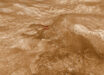
The newly-released map shows the locations and abundances of secondary minerals formed through interaction with water on Mars. It is based on the analysis of orbital imaging spectroscopy data from the Observatoire pour la Mineralogie, l’Eau, les Glaces et l’Activité (OMEGA) instrument aboard ESA’s Mars Express spacecraft and the Compact Reconnaissance Imaging Spectrometer for Mars (CRISM) instrument aboard NASA’s Mars Reconnaissance Orbiter. The map is expected to foster synergy between orbital and landed missions, particularly for future missions and to pinpoint prospective resources for human exploration.

The detailed global map of hydrated mineral deposits on Mars; various landing sites and areas of interest are shown; Mawrth Vallis is an ancient water outflow channel that is rich in clays; Oxia Planum is another clay-rich region and has been selected as the landing site for ESA’s Rosalind Franklin rover; Meridiani Planum straddles the Martian equator and was the landing spot for NASA’s Mars Exploration Rover Opportunity in 2004; Valles Marineris is one of the largest canyons in the Solar System’ Gale crater and Jezero crater were the landing sites of NASA’s Curiosity and Perseverance rovers in 2012 and 2020, respectively. Image credit: ESA / Mars Express / NASA / Mars Reconnaissance Orbiter.
On Earth, clays form when water interacts with rocks, with different conditions giving rise to different types of clays.
For example, clay minerals such as smectite and vermiculite form when relatively small amounts of water interact with the rock and so retain mostly the same chemical elements as the original volcanic rocks. In the case of smectite and vermiculite those elements are iron and magnesium.
When the amount of water is relatively high, the rocks can be altered more. Soluble elements tend to be carried away leaving behind aluminum-rich clays such as kaolin. The big surprise is the prevalence of these minerals.
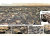
Ten years ago, planetary scientists knew of around 1,000 outcrops on Mars. This made them interesting as geological oddities.
However, the new map reveals hundreds of thousands of such areas in the oldest parts of the planet.
“This work has now established that when you are studying the ancient terrains in detail, not seeing these minerals is actually the oddity,” said Dr. John Carter, a planetary researcher with the Institut d’Astrophysique Spatiale at Paris-Saclay University and the Laboratoire d’Astrophysique de Marseille at Aix-Marseille University.
From the smaller number of aqueous minerals that the researchers previously knew were present, it was possible that water was limited in its extent and duration.
Now, there can be no doubt that water played a huge role in shaping the geology all around the planet.
The big question is whether the water was persistent or confined to shorter, more intense episodes.
While not yet providing a definitive answer, the new results certainly give researchers a better tool for pursuing it .
“I think we have collectively oversimplified Mars,” Dr. Carter said.
“Planetary scientists have tended to think that only a few types of clays minerals on Mars were created during its wet period, then as the water gradually dried up, salts were produced across the planet.”
While many of the Martian salts probably did form later than the clays, the new map shows many exceptions where there is intimate mixing of salts and clays, and some salts that are presumed to be older than some clays.
“The evolution from lots of water to no water is not as clear cut as we thought, the water didn’t just stop overnight,” Dr. Carter said.
“We see a huge diversity of geological contexts, so that no one process or simple timeline can explain the evolution of the mineralogy of Mars. That’s the first result of our study.”
“The second is that if you exclude life processes on Earth, Mars exhibits a diversity of mineralogy in geological settings just as Earth does.”
“In other words, the closer we look, the more complex Mars’s past becomes.”
The team’s results were published in two papers in the journal Icarus.
_____
John Carter et al. A Mars Orbital Catalog of Aqueous Alteration Signatures (MOCAAS). Icarus, published online August 20, 2022; doi: 10.1016/j.icarus.2022.115164
Lucie Riu et al. 2022. The M3 project: 3 – Global abundance distribution of hydrated silicates at Mars. Icarus 374: 114809; doi: 10.1016/j.icarus.2021.114809