
It needn't be a Eurocentric world
It came as a surprise to me after over 20 years of seeing "normal" world maps to come across an upside down one. The most surprising thing was that I found it surprising. It is completely artificial that we have North at the top of a map.
The convention came a few centuries ago when Northern hemisphere, European navigators started using the North star and the magnetic compass. Before that, the top of the map was to the East which is where the word orientation comes from.
Upsidedown pride
Buy our new t-shirt!
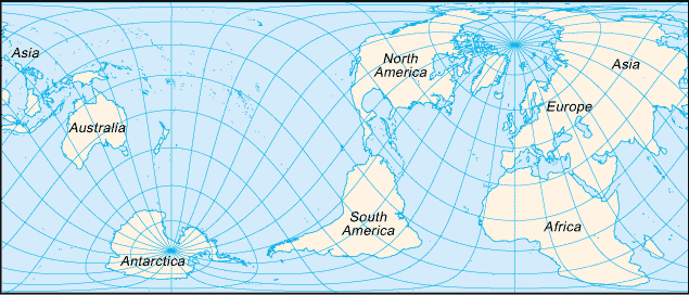
Then a friend bought me an Australian map that was on sale in Japan. Not only does it have South at the top, but it is also "rotated" so that China, Indonesia and Australia are in the centre rather than Europe and West Africa.

Hard to believe that I'd not only been educated into one stereotype about maps, but even after learning that stereotype had failed to spot the other one.
I'm interested in Upsidedown Maps because they make me rethink the world. It's important to remember that there are people all over it. Since hanging one on my wall I've learnt geography again. You can reevaluate the world from scratch, as if it was a brand new alien landscape.
Indonesia looks like by far the most interesting place from orbit.
The first three following map images are copyright ODT, reproduced with their permission. You can buy them from ODT.
McArthur's Universal Corrective Map of the World has a fabulous history, made by an Australian who was tormented for coming from the "bottom of the world". It was the first modern south-up map, published in 1979. Read about it at ODT.

More revenge from Australians, with their What's Up? South! map. This has a Van der Grinten compromise projection. Read about it at ODT, and make sure you read the picture of the first panel at the bottom left of the map.

The Hobo-Dyer map is an equal area projection. One side of it has north on the top, the other has south. Read a full description at ODT.

Philip Print in London sell an interesting world map by Pierre Desceliers, 1550. It is designed to be placed on a table and read from both sides. Half of the map is inverted, and the other half is the right way round.

Next time you see a globe, be subversive and turn it upside down as well. Email me if you have or know of any globes which are printed and designed to be viewed upsidedown.
My rotated and upsidedown map is from: Universal Press Pty Ltd. Australia, 1 Waterloo Road, Macquarie Park, NSW 2113. Telephone: 61 2 857 3700 Facsimile: 81 2 888 9850. New Zealand, Level 1, 42 Olive Road, Penrose 1135 Auckland. Telephone: 64 9 526 0241 Facsimile: 64 9 526 0249
The Map Store and other places claim to sell the map pictured at the top of this page, although it is out of print. The Globe Corner Bookstore has a World Down Under map for sale. Hema Maps have an upsidedown world map calendar. Australia Fare sell an inverted map. You can search for all manner of maps at Map Link.
ODT have three south up maps with a choice of projection; you can buy them from ODT by phone. There is a short history of ODT in the Northeastern University magazine.
An upsidedown map of the Americas called A New World of Understanding by Jesse Levine is available from Laguna Sales, 4015 Orme Street, Palo Alto, CA 94306 or 415-494-7729. [ Source: Jim by email, referencing Interfaith resources page. ]
Arabia (Ancient): They put south at the top. This is because when you wake up and face the sun, south is on the right. Because of positive associations with the right as opposed to left, they put that on top. Yemen is so named because it is on the "yamin" right of Arabia. And of course, with the sea to the south of them there was nothing "on top" of the country, so they prefered it that way. Europeans learnt mapmaking from the Arabians and flipped the map to make themselves on top. [ Source: email from Jessica who heard a talk by an American Muslim scholar called Hamza Yusuf. ]
Arctic/Antarctic: A natural map of the poles has either south or north at the top and at the bottom - indeed, in all directions. Unusually, the opposite compass direction will be located in the centre. [ Source: email from Fred made me realise this ]
Biblical Times: There is evidence from the Torah that east was at the top of maps. In Genesis, Abraham's nephew, Lot, is captured in war and carried away. Abraham races to the rescue. He and his men catch up with Lot's captors, and set him free, in "Chovah, which is to the left of Damascus." (Gen. 14:15). Chovah is north of Damascus. In Psalms 89:13 it says, "The north and the right, You created them". This implies that right is synonymous with south, so you are facing east when you read the map. [ Source: email from Toby ]
Medieval Europe: Jerusalem was on top because that was the Holy Land. This meant that east was more or less at the top. [ Source: email from JDG who has personal experience of medieval records ]
China (Ancient): The Chinese were the first to invent the compass, which they always thought of as pointing south. South was a sacred direction, in ceremony the king would always face south. [ Source: email from Andy ]
China / Japan: In modern times, Chinese and Japanese maps are split at the Atlantic, so have Japan right in the middle and China near the center. [ Source: personal observation by Francis in early 2003; email from Jez who used to live in Japan ]
New Zealand: Upsidedown or "corrected" maps are becoming more popular, especially with tourists. For example, a tea towel with such a map saying "no longer down under". [ Source: email from Jez who has bought such a towel ] As a child, a New Zealand friend always referred to the maps with North at the top as "the wrong way up", and this page's "upside down" maps as "the right way up" or "the way it's supposed to be..." [ Source: email from CH ]
Russia: The former soviet union placed its maps with the USSR at the center.
US, Canada: Maps are as in Europe, with the Americas on the left [ Source: email from mp, email from Martin ]
This 1943 illustration of South America (on a magic realist map site) by Joaquin Torres Garcia is an early example of an upside down map. An article titled Latino Art Crossing Borders has more details.
There's an interesting looking book called Seeing Through Maps; you can download the first chapter for free. For a general history and discussion of mapmaking try The Mapmakers by John Noble Wilford.
The Dymaxion Map has no compass direction consistently facing the same way; it is in the form an unfolded icosahedron. It was made by Buckminster Fuller, a sustainability advocate ahead of his time. His intriguing World Game is played on a playground sized version. This reminds me of a similar small world map made by the CIA (on university of Texas website).
You might also be interested in the Peters Projection which is a map accurately representing land area. Although make sure you read about Peters vs Mercator and how there are other more globe-like non-rectangular maps. This paper on the Peters Projection mentions upsidedown Peters maps.
On the TV series The West Wing there was an episode featuring a fictional "Organization of Cartographers For Social Equality". To start with they promote the use of Peters Projection maps in schools, but later on suggest upsidedown maps: In addition, they propose ending top/bottom attitudes by putting the northern hemisphere on the bottom of the map. C.J. protests that they can't do that, "'cause it's freaking me out." (quote from an episode synopsis that used to be on gist.com)
The nascent International Society for Global Inversion believes that flipping iconic world maps everywhere would be a symbolic ceremony to help mankind break its old thought patterns, and act in a more ecological way. I like the idea of using an upsidedown texture on the various small earth maps often found in logos.
Some people find navigating easier if they rotate maps so that up is in the direction that they are facing. There is a small tradition of printing road maps upside down to make this more convenient. You can buy California Upside Down which is double sided, with north at the top on one side, and south at the top on the other. Similarly, there's an Upsidedown Map of California [ Source: email from Angie ].
Star maps are mirrored along the east-west axis, so north is at the bottom and south at the top. You can lie down and hold the map over your head, comparing it with the sky. Anybody else know examples of maps which are reflected (rather than rotated)? [ Source: forum posting by beejay ]
Most of the world's land mass is in the northern hemisphere, and Deley's solar mythology page discusses how this has influenced map orientation. It goes on to explain why the direction of clockwise is bias - because in the north sundial shadows move that way. Anyone know of any anti-clockwise clocks which have been marketed as "down under"? Deley also gives a link to Straight Dope's take on why North is always up.
A Guide to Unusual Maps on the Web has lots of useful links to all manner of maps, including some upsidedown ones.
Look at pages that link to this page for some interesting related sites and information.
Please email me:
Thank you to everyone who has emailed me and contributed to this page. That kind help and support is what makes the internet. More recently I've credited people as sources so we can track where information is from.
| To Francis's page | $Id: index.html 638 2004-10-11 01:22:52Z francis $ |