File:Mars topography (MOLA dataset).png
Jump to navigation
Jump to search

Size of this preview: 800 × 361 pixels. Other resolutions: 320 × 144 pixels | 640 × 289 pixels | 1,024 × 462 pixels | 1,280 × 578 pixels | 2,880 × 1,300 pixels.
Original file (2,880 × 1,300 pixels, file size: 2.24 MB, MIME type: image/png)
Captions
Captions
Add a one-line explanation of what this file represents
Summary[edit]
.png&action=edit§ion=1)
| Description |
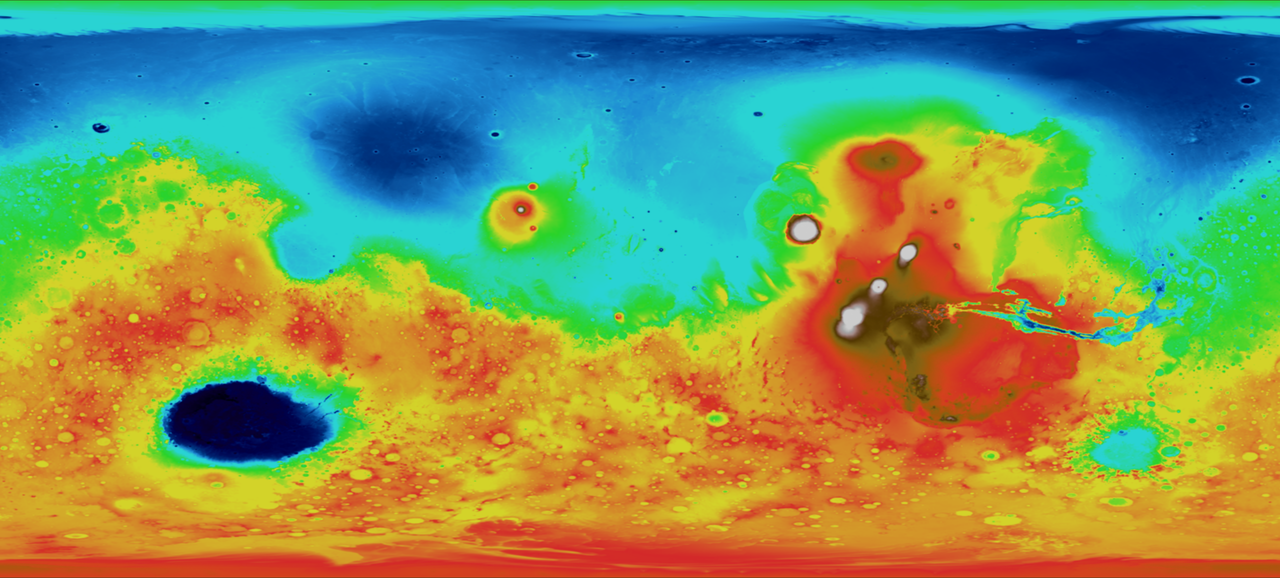
English: This map depicts topography, or surface features, of the planet Mars. In this image, white and red features are highest in relative elevation, while green and blue areas are lowest. This image was made possible by data from the Mars Orbiter Laser Altimeter (MOLA), which bounced a laser off the surface of the planet and calculated the distance traveled by the beam of light. |
| Date | Data collected in 2000 |
| Source | |
| Author |
NASA - Goddard Space Flight Center |
| Other versions |
.png) .png) |
.jpg)
Licensing[edit]
.png&action=edit§ion=2)
| This file is in the public domain in the United States because it was solely created by NASA. NASA copyright policy states that "NASA material is not protected by copyright unless noted". (See Template:PD-USGov, NASA copyright policy page or JPL Image Use Policy.) | ||
 |
Warnings:
|
File history
Click on a date/time to view the file as it appeared at that time.
| Date/Time | Thumbnail | Dimensions | User | Comment | |
|---|---|---|---|---|---|
| current | 20:49, 4 March 2009 | | 2,880 × 1,300 (2.24 MB) | Tryphon (talk | contribs) | Gimp messed the colors up somehow, converting from TIFF to PNG; this one was converted using Imagemagick and seems fine. |
| 20:23, 4 March 2009 |  | 2,880 × 1,300 (2.13 MB) | Tryphon (talk | contribs) | == Summary == {{Information |Description={{en|1=This map depicts topography, or surface features. In this image, white and red features are highest in relative elevation, while green and blue areas are lowest. This image was made possible by data from the |
You cannot overwrite this file.
File usage on Commons
The following 3 pages use this file:
File usage on other wikis
The following other wikis use this file:
- Usage on fr.wikipedia.org
- Usage on fr.wikibooks.org
- Usage on zh.wikipedia.org
.png&oldid=144166489)